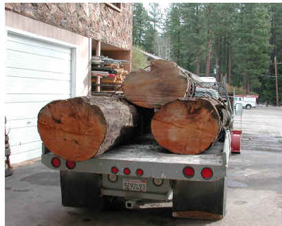
While we’re re-visiting bristlecones and foxtails, the Here are three interesting online articles, each of which discusses areas in the Sierra Nevada CA, which are now submerged, but where forests grew in the Medieval Warm Period. Many readers of this blog will have read articles about trees being disgorged from receding glaciers and it’s hard not to wonder about comparisons.Scott Stine, who has published in Nature about the phenomenon, has on line article here from 2001. Here is an interesting picture showing submerged medieval trees from Tenaya Lake, Yosemite National Park.

Picture from Stine article: Tenaya Lake, Yosemite National Park (elev. 8,150 ft). 1,000 years ago, trees grew in then-dry Tenaya Lake. Today only their tops show: still rooted in as much as 70 feet of water.Stine also discusses other well-dated medieval (G-1 AD1100) trees from Walker Lake, Mono Lake, the West Walked River, Owens Lake (desiccated in the MWP), Osgood Swamp near Lake Tahoe, Independence Lake north of Tahoe and Fallen Leaf Lake south of Lake Tahoe. Stine observed:
Indeed, increasing evidence indicates that there is little that is climatically “normal” about the past century – and- a-half; it appears, in fact, to be California’s third- or fourth-wettest century-scale period of the past four or more millennia. Since statehood, Californians have been living in the best of climatic times.
Philip Catarino, one of the divers cited by Stine, has a 2000 article online here. He observed:
During the last 500 years, a wet climate, punctuated by intermittent but substantial droughts, began to dominate the region, and lake levels again rose and cirques glaciers reformed in the Sierra. A series of substantial droughts are documented during this period, however. Dozens of submerged tree stumps are located up to 300 feet below the present day level of Donner Lake a tributary of the Truckee River; carbon –14 samples from one stump date from AD 1433 (Lindstrom and Bloomer 1994). Another warm period, documented by tree-ring studies and Truckee River run-off, dated between AD 1579-1585, and again around AD 1630 (Hardman and Reil 1936). It is possible that Lake Tahoe contributed relatively little water to the Truckee River during the last 200 years. During the century between the mid 1700s to mid 1800s, the level of Lake Tahoe may have been below its rim, with no water flow into the Truckee River. This is documented by a submerged stump in the Upper Truckee River Delta dating from AD 1720 (Lindstrom 1996a), one from Donner Lake dating from AD 1800 (Lindstrom and Bloomer 1994) and one in Emerald Bay dating to AD 1840 (Lindstrom 1992). The 40 years between AD 1875-1915 were the longest period during which the flow of the Truckee River was above the average. During the AD 1930s drought, Lake Tahoe ceased to flow from its outlet for six consecutive years. Drought within the last decade (late 1980s to 1990s) either stopped Tahoe’s flow into the Truckee or reduced it to almost nothing.
While there have only recently been rooted trees found in Fallen Leaf Lake, there is a considerable amount of avalanche debris located beneath the waters of the lake. The current trees have recently been sampled and the dating available in the fall of 1998. The size and scope of the tree discovered dwarfs all other trees that have been discovered in the Sierra. It appears to be a Jeffery Pine that is over 27.5 m tall and a diameter at breast height (dbh) of over 244 cm. It raises many questions on how severe a drought was that lowered the lake level by a 30.5 m and remained there long enough for a tree to root and grow this size before being submerged by a more wet climate regime.
Kleppe, 2005 here reported:
The author of this paper has discovered large trees rooted at a depth of 36.5 m (120′) below the existing surface level of Fallen Leaf Lake. Fallen Leaf is one of the major watershed areas for Lake Tahoe. Some of these trees measure over 30 m (98′) tall with a circumference of over 4.5 m (15′), which is an indication that they were over two hundred years in age when they died. The significance of this discovery is the fact that for these trees to be rooted below the surface of the lake, the lake must have been down at least 36.5 m for over two hundred years. ….The carbon dating of the raised tree samples indicated that the tree died in A.D. 1215 ± 40 years….
Evidence of these medieval droughts appears at many sites in and adjacent to the central Sierra, i.e., Mono Lake, Tenaya Lake, the West Walker River, Osgood Swamp (Stine, 1994), Fallen Leaf Lake (Kleppe and Norris, 1999; Kleppe, 2004), Lake Tahoe (Lindstrom, 1990), and Pyramid Lake (Benson and others, 2002). These recent studies of selected tree stumps rooted in present day lakes, marshes and streams, suggest that California’s Sierra Nevada experienced severe drought conditions for more than two centuries before 1112 A.D. and for more than 140 years before 1350 A.D. During these periods runoff from the Sierra was significantly lower than during any of the persistent “dry spells” that have occurred in the region over the past 150 years.
Here is a picture of a medieval tree recovered from Fallen Leaf Lake:
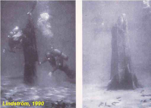
NAS panelist Franco Biondi, together with Kleppe and Scotty Strachan , has a 2005 poster entitled Underwater Dendrochronology of Sierra Nevada Lakes with the following nice picture of divers in 1990
They state:
The master chronology was formed by a total of 22 series from 16 different trees, and spanned the period AD 543-2003, or 1461 years, with sample depth à⣃¢’¬°à⣠3 series from AD 654.. For dendrochronological dating, we developed a western juniper (Juniperus occidentalis) reference chronology that spans the period from AD 543 to 2003. One underwater sample, i.e. a branch cross section cut from a standing tree, was crossdated with the master chronology for the period AD 1085-1153.
Obviously there have been a lot of hydrological changes in the Sierra Nevadas since the MWP.
References:
JOHN A. KLEPPE, ,2005. A study of ancient trees rooted 36.5 m (120′) below the surface level of Fallen Leaf Lake, California Journal of the Nevada Water Resources Association http://www.ee.unr.edu/downloads/nwra2005No3.pdf
P.R.Caterino, 2000. RECONSTRUCTING ANCIENT AVALANCHES OF THE SIERRA NEVADA RANGE. http://www.avalanche.org/~moonstone/ISSW%2098/caterino.htmLindstrom, Susan G. 1985. Archaeological investigations at Tallac Point (CA-ELD-184). U.S.F.S, LTBMU, South Lake Tahoe.
Lindstrom, Susan G. 1990. Submerged Tree Stumps as Indicators of Mid-Holocene Aridity in the Lake Tahoe Region. Journal of California and Great Basin Anthropology. 12(2):146-157. Malki Museum. Banning
Franco Biondi, John A. Kleppe, and Scotty Strachan 2005 Underwater Dendrochronology of Sierra Nevada Lakes http://woods.geography.unr.edu/Posters/FallenLeafLakePoster.pdf
Ccott Stine, 2001. The Great Droughts of Y1K, Sierra Nature Notes 1 http://www.yosemite.org/naturenotes/paleodrought1.htm


52 Comments
It’s actually West Walker River.
Owens Lake is once again desicated due to diversions of the Owens River to supply Los Angeles with water. One other thing about Ownens Lake though, is, other than the odd Cottonwood there are really no native trees anywhere near it today.
Further evidence of the Truckee River’s fickle nature is that it ends in a sink, not a saline lake (this river flows east, into the great basin, never reaching the sea). If the flow was consistently in a range where it has been over the past 20 years, over, say, the past 2000 years, I’d expect a saline lake where there is currently only a sink out east of Sparks, NV.
According to the highly technical jaeeb (jae eye-balling) statistical procedure, the almost all of the dates at which these trees flourished coincided with periods of high sunspot numbers. Figure 13 in Jan Veizer’s paper. Of course, that could just be a coincidence.
Ooohhh, this will be fun! I spend a week each summer at a family camp on Fallen Leaf Lake
run by the Stanford Alumni Association. Most of the other parents and the college-student
counselors have completely bought into the hockey-stick notion that the present climate is
a complete anomaly. I’ll get to come back with “did you know…”
jae: This is the most
damningconvincing article I have read arguing that “Man” is not the cause of the earths current temperature patterns. It would be very interesting to see Steve dissect this paper as he has Juckels. Or at least know what type of review process Veizer’s paper went through as a comparison.Did a little more looking. The BBC did a follow up on one of Veizer’s eailer papers. In it they quote:
So, what is the “incorrect and based on questionable methodology”? Is Veizer as creative as Juckels appears to be?
JP, if you need a critique of any paper even potentially harmful to AGW cause, check the usual suspects.
6: Yeah, criticism from folks who do not believe there was a significant MWP or LIA and have no way to explain these proven climate phenomena.
JP: There are dozens of peer-reviewed studies that suggest solar-induced changes in climate here.
Darn, the link didn’t work. I’ll try again.
Re #1:Steve Sadlov
Just as a point of interest, partial water flow was restored to the Lower Owens River yesterday.
link
Didn’t the Danish SKY experiment recently confirm the cosmic ray positive influence on cloud formation?
Veizer’s paper fails to consider forcings by regular changes in the earth’s orbital parameters. These were shown by researchers in the 1980’s to contribute significantly to long-term climate oscillations during the last 900K years. Not that he’s wrong about insolation, just that it’s very unlikely to be the whole explanation.
12: Agreed. Based on what I’ve read, there are a lot of complex relationships that are not yet understood completely. Veizer doesn’t have all the inputs, or there would be much better correlations. However, I think he has explained some of the most important variables.
RE: 7 JAE,
Don’t forget, that with Mann 2006 the HT has once more “moved on.” Now the MWP and LIA existed, but they were European phenomena. The colonization of Greenland and the colony’s demise at the onset of the LIA are teleconnected to Europe. The fact that the jet stream blows from west to east in the NH must mean that North America is teleconnected to Europe as well. Therefore all NH proxies are teleconnected to Europe prooving the the LIA and MWP were European only.
The few Pacific coral proxies that Mann found which show a reverse trend to the MWP and LIA are teleconnected to the rest of the globe, but not to Europe.
#1 Steve Sadlov: I’m afraid you are wrong on the ultimate destination of the Truckee River. It ends in Pyramid Lake, home of the famous Lahontan Cutthroat trout. It would be interesting to see if there are any papers (I’m sure there must be) on past fluctuations in the levels of lakes like Pyramid Lake in Nevada (As well as Sevier Lake and Utah Lake in Utah) and see how they square with the hydrologic information from these submerged tree studies. I would think that there would be a close correlation with Pyramid Lake, but that these lakes in Utah would be linked in some periods and diverge at other times.
when i was attending college in the late 90’s my geology professor was very adamant that “global warming” is part of a normal cycle and that thousands of scientists attest to this fact. the media and politicians have spun the myth that we can do anything about the warming trend to appeal to the general publics need to control the world around them. i’m glad to see that there are other citizens who don’t buy into it.
Re: #14, Brooks
Good summary of the HT position. But there has been no net warming of the southern hemisphere in the current AGW period, so exactly how can they claim MWP and LIA were NH phenomena but today’s warming is not?
That is, of course, another way in which science does not work. Science allows for old, long thought to be settled, issues to be reopened when new evidence or a better theory comes along. One that accounts for all the evidence and makes better predictions that can be tested.
Wanking around with computer models is not science.
As stated in Underwater in the Sierra Nevada “there is considerable avalanche debris…” What effect would/did an avalanche have on the lakes water level?
Re #19
Displacing water in the lake would have the immediate effect of raising the water level. Whether or not it would have a long term effect would depend on the rate of inflow/outflow and evaporation.
To clarify: are we talking about half a mountain sliding into a pond or a few boulders dropping into lake Tahoe?
Reply to self
My prior comment wouldn’t hold true if the avalanche terminus was above the historic water level and was subsequently drowned by the rising lake.
Re #21,
Looking at the Caterino document that Steve linked in the article, Fall Leaf Lake had various degrees of avalanche activity. Any amount of material that slid into the lake would raise the lake level unless the lake was already full to the rim. The avalanche debris presumably does not represent a single event but was associated with a period of increased precipitation. So it would seem that the avalanches accelerated the lake rise that was brought on by the precipitation.
Earle, I understand the avalanche falling short of the lake and the water eventually rising to cover the debris, but what about the opposite sceanario where the debris dumps into the (shallow?) lake and the water level suddenly rises 100′! Is there information to the contrary? Is this legitimate evidence of climate change or sudden readjustments in the geology?
24: Maybe for one lake, but surely not for all of them.
Re #24
Without knowing the details of the lake and the submerged landslides I couldn’t argue one way or the other on your comment. I’m sure it’s happened somewhere, perhaps even in these Sierra Nevada lakes. What the final rise in a lake would be for one of these landslides is based on the volume displaced and the size of the lake. The Caterino paper raises your question in the second to last paragraph with the conclusion that more mapping is needed to better answer it.
Regarding #5 here’s Shaviv’s rebuttal of Rahmstorf:
Click to access RahmstorfDebate.pdf
and Shaviv and Veizer’s response to Rahmstorf’s response:
Click to access RahmReplyReply.pdf
Google Earth in 3-D provides a good perspective of the terrain surrounding Tenaya Lake. The hills and mountains rise 500 to 2000 feet above the lake surface. The eastern mountain abuting the lake appears to have a very steep slope and to this layman looks to be a good candidate for a past avalanche. This is something that should be studied further. I was unable to quickly locate some of the other lesser lakes but I’m curious to examine their surroundings.
Some people are very alarmed about the Glaciers in Glacier National Park in Montana receding. Scott Stine hypothesizes the jet stream was the cause of the mega droughts in California and at the same time the glacier advances in Alaska. Does anyone know how Glacier National Park would fit into this theory? If southern California is getting a lot of rain, is northern Montana dry? Anyone an expert on the jet stream?
If a long term blocking High is anchored over the Western Rockies like the famous
4-Corners High, those areas beneath will be under persistent subisdence and adiabatic
drying. The Southern Branch of the Polar Jet would be driven southwards. In that case,
California could be inudated with attendant precipitation from Martitime storms translating
through the Jet Stream, while the Northern Rockies remain dry. I’m not sure that this has been the case; in El Nino years,
California usually gets plenty of winter precipiation (as does the East Coast), while the
middle part of the US remains dry and mild.
Re #24: There’s a raft of evidence for those mega-droughts quite aside from those trees. The amazing thing is that public policy continues to be made on the assumption that there won’t be a recurrence. We will be very, very sorry about that someday.
mr bloom…
you said:
“The amazing thing is that public policy continues to be made on the assumption that there won’t be a recurrence.”
could you provide an example?
#31. I agree that there’s much evidence for a drier and warmer MWP in California besides these trees. The even more amazing thing is public policy is made on the Mannian assumption that medieval California tree rings came from frigid cold, rather than dryness.
Re #32: I take it you don’t live in California. My favorite telling anecdote on this subject is from the last bad (relatively speaking) drought here in the mid-’70s. The major part of the SF East Bay region (where I live) relies for its water supply on a single Sierra reservoir, the Mokelumne. By the end of the final summer of that drought, the reservoir was nearly *drained*. Fortunately it started raining again the following winter, but if it hadn’t it would have taken some rather extreme measures to find alternative water supplies for that service area of about 1,000,000. Other Bay Area water districts were in similar dire straits; for example, Marin County (population @ 200,000) had lost its normal water sources and was reliant on a pipe strung across the Richmond Bridge (connecting ultimately to the Delta if I recall correctly). If the extreme drought had gone on, I’m sure that similar cross-connections to balance supply, massive ground water pumping, additional rationing measures and diversion of remaining agricultural supplies could have stretched things for another two or three years, but after that there would have been very big trouble (and of course some of those measures constitute major trouble in and of themselves). Since then, we have roughly doubled the number of people reliant on Sierra water to something in excess of 30,000,000, so that even a repeat of the ’70s drought will be much worse. A drought on the scale of the big ones in the Holocene climate record hardly bears thinking about, which I believe returns me to my original point. There’s certainly no effort being made to plan to withstand such a drought.
Re #33: “The even more amazing thing is public policy is made on the Mannian assumption that medieval California tree rings came from frigid cold, rather than dryness.” You continue to overstate vastly the significance of medieval warming (or the lack thereof) to both clinate science and public policy.
34 Gloom and Bloom.
Well, they are building a Seawater Desalination plant were I live. I am sure there are similar things happening in other areas of California, [the internet says 18 plants in Califorinia on the plans] The plant being built in San Diego County is going to be the largest in the world producing 50m gallons of water a day.
Steve Bloom says:
I come from a land down under, and now I live in the West Bay. Where I used to live we know a lot about droughts and water shortages, and these are local issues, and they are cyclic things.
I think that he is simply pointing out that the AGW crowd are deniers as far as the MWP is concerned. It seems that the MWP was far more widespread than the AGWer will admit to, and that there is good evidence that temperatures were higher than they are today, even in the Sierras.
This casts doubt on the AGW claims that human contribution to the global increase in CO2 is responsible for a large portion of the increase in global average temperature that we have seen over the last 100 years or so, and that things will necessarily get worse due to the increase in CO2 caused by us.
The most responsible thing to do, IMO, is to spend money understanding more about how global climate actually works and all of the inputs to temperature increases and decreases …
#36 Right, only climate science runs the world. Very telling.
Re #36: Rocks, what’s the available supply from those plants relative to how much is needed, and what’s the cost per gallon, and what kind of total money are we then looking at? Those plants will be a big albeit expensive help in the event of a repeat of the ’70s drought, but beyond that?
Right loki on the run,
gotta get rid of the MWP or the fear/guilt factor won’t stick.
ps my reference in #38 should be for 35 not 36.
#34 well, mr bloom, that is all very interesting. but my question was, could you provide an example of public policy being made on the assumption there wont be another severe drought?
i dont think an increasing population is a good example of a public policy.
#39 Don’t have numbers for you, but what’s so bad about it? Don’t notice the cost for the one being built in my area yet, and it’s already being paid for. We do what we have to do to live here on earth- and California is a desert and desert-like in most places after all with droughts. Alot of coastal cites are expensive to live in anyway and hey it could create more jobs. We already pay a buck or more for a bottle of water at the store-it costs more than gasoline. I’d rather pay for desalination plants then the other things they take my money for.
BTW-just a snippet, my husband said they just announced on the radio that a study released today says that “Hollywood” (or the movie industry) is either the highest producer of CO2 in California, or the second highest (not sure exactly) of CO2 producing industries in California) The DJ was having a good time with that one.
Steve Bloom says:
So Steve, you’ll get the Sierra Club to throw its support behind finishing the Auburn Dam, the Peripheral Canal, and the other big water projects that were designed to make California’s water system resilient in the face of big droughts?
W.R., Earle:
Having spent a lot of time on Fallen Leaf Lake, I’m hard pressed to see how there could have been major enough slides to significantly affect the water level. Very little of the perimeter of the lake (
Let’s try that again, without the “less than” symbol…
W.R., Earle:
Having spent a lot of time on Fallen Leaf Lake, I’m hard pressed to see how there could have been major enough slides to significantly affect the water level. Very little of the perimeter of the lake (less than 10%) is slide-susceptible at all. Really only directly under Cathedral Peak could you get a major slide. Even there, in a 1-by-3-mile lake, I’m having a lot of trouble getting past a few-foot rise (which might be temporary, as it would permit increased evaporation from increased surface area) from a major slide, as might be triggered by an earthquake.
Re #39, cost of desalination.
Per http://www.desware.net/desa9.aspx
Present cost for desalinating seawater averages US$1.00/cu. meter, or roughly 0.4c./gal. New plants about half that, and better techniques might halve that again, or say 0.1 – 0.2 c./gal. I’m assuming these costs include amortizing the plant.
Compare this to where I live (Eldorado, NM, near Santa Fe). We pay about 1c./gal, which translates to a $50-75/mo. water bill with a bit of outside gardening. So the economic impact of switching urban California to desalinated seawater should be pretty minimal. Aside from raising the capital to build the plants, especially if it’s an emergency program.
Does seem like California needs to do some contingency planning. Central Valley agriculture would basically vanish for a MWP-style drought.
Cheers — Pete Tillman
Steve pointed at this thread and for me the interesting part is Tenaya Lake being totally dry. I find that amazing. This is a glacial lake fed by precipitation from the high Sierras. For it to dry up precipitation must have dropped dramatically to a level where evaporation was greater than inflow (on an annual basis).
I looked for another explanation.
Glacial lakes are formed by glaciers gouging a depression in a valley and/or depositing a morraine. Once a glacial lake forms it can’t get any deeper and will slowly get shallower. For it to get deeper there has to be geomorphological or geological reason. I can think of 3 possibilities.
1. The underlying rock is permeable and water percolates through the underlying rock allowing the lake to drain underground at times of low precipitation and the lake only fills at times of high precipitation. The rocks in this area are granite so this possibility is eliminated.
2. Avalanches happened at exactly the right location to form the lake. That is, it isn’t a glacial lake at all. It just looks like one. This is possible i suppose, but doesn’t strike me as a reasonable possibility. The USGS thinks this is a glacial lake.
3. The lake has deepened because of tectonic activity. Some lakes are formed by tectonic activity, but it would be an amazing coincidence if it happened at exactly the right location to deepen a glacial lake. Or again it’s a lake that looks glacial but isn’t. Even more unlikely than 2.
So I am left with a dramatic reduction in precipitation as the only explanation. It would be an interesting project to use current outflow from the lake, evaporation estimates and local precipitation data to calculate how low precipitation would have to fall to dry up the lake.
Amazing, isn’t it?
Fissure in the granite?
==============
er, fault.
=====
Philip_B, I think there are more possibilities:
4) the water previously in the lake is not the result of precipitation, but is actually a remnant of some previous glacier. It has been steadily draining, slowed by precipitation. Now, it’s done. (looking at the wikipedia picture, I don’t see a lot of elevation above it, so it seems like an unstable place for a lake)
5) The lake outflows through Tenaya creek. The flow through the creek could have been increased, either by some natural process or human action.
6) The weather could have made it a lot more dry up there, or extra solar insulation could have helped evaporate the water, with no precipitation change.
49 and 50: that occurred to me also. Sprung a leak, as it were. Later got blocked by sediment?
3 Trackbacks
[…] discussed medieval drought on a number of occasions, including a discussion of submerged timber here, a topic also visited by Trouet coauthor Nick […]
[…] in California were higher than at present, discussed here and here. Post-medieval lakes have even submerged medieval trees. Miller (2006) discussed here and here estimated great warmth in alpine California […]
[…] […]