The Ward Hunt Ice Shelf has a rather complicated history and stratigraphy. Fortunately, the original studies of the Ward Hunt Ice Shelf in the 1960s and 1970s were done by geologists rather than climatologists and, as a result, there are decent maps in the early literature showing relevant details of the stratigraphy. (Compare their maps to Jacoby’s inability to provide a location of the Gaspé cedars sampled in 1983 as this was before GPS.)
Figure 1 below is a surface plan map of the Ward Hunt Ice Shelf from Lyons et al 1971, showing the location of the 1961-62 break. I’ll provide a discussion of these below, but look carefully at the figure first.
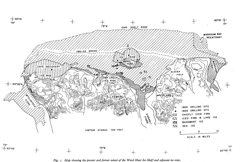
Lyons et al 1971 Figure 1.
The map is a surface plan which shows clearly a distinction between outcrops of older “basement ice” (stipple) and younger “iced firn and lake ice” (hatched) and “ice rises” (vertical).
Seaward of Ward Hunt Island, they did not report any basement ice: Outer part of Ward Hunt ice shelf consists of a 15-18 m thick platform of sea ice conformably overlain by approximately 25 m of iced firn and interstratified lake ice.
Landward of Ward Hunt Island, older “basement” ice was found with a thick capping of dust formed by ablation of the ice:
From the latitude of Ward Hunt Island south, an older “basement” of interdigitating sea and brackish ice (Lyons et al 1971) lies with angular unconformity beneath the interstratified iced firn and lake ice. A thick capping of ablation produced dust marks the surface of unconformity.
The outcrops of basement ice shown in Figure 1 are connected by a syncline of basement ice (this is a term used in geology). Lyons et al 1973 interpreted this stratigraphy as evidence of the following phases: (1) formation of the “basement” ice; (2) a period of ablation in which the dust layer was concentrated; (3) a recent period of accumulation; (4) modern ablation.
They reported that the two southernmost holes in the Ward Hunt ice rise showed only iced firn to 25 m and that in the northernmost hole 33 m of interlensed iced firn and lake ice overlie 19 m of sea ice, bottoming in till at 52.3 m. There was no dust layer in this hole in cores from the ridge and trough holes 1,6 km to the north. Lyons et al concluded that ” all ice in the three cores is younger than the [dust layer]”
One of the first take-home messages from this map is that not all of the Ward Hunt ice shelf is “old”. The part that broke off in 1961-62 is younger than the dust layer marking the end of the ablation period.
They reported that the dust layer (i.e. basement ice) was not encountered in 25 m cores in the Camp Creek and Cape Discovery ice rises, but that an exposed outcrop of the 48 m Camp Creek ice rise (from the creek) showed 3 heavy dust layers at its base, overlying 2 meters of possibly basement ice.
Dating
The early writers (Crary, Lyons, England) were interested in dating both the basement ice and the end of the first ablation period. Crary 1960 stated:
The driftwood pieces located back of the present Ellesmere Island ice shelf with ages varying from 3000 to 6120 years could not have arrived at their present positions in the presence of the ice shelf and therefore give a maximum age for the beginning of the ice shelf. Although this driftwood could most easily have been brought in during a period of an open or nearly open Arctic Ocean, sample 261A with an age of only 980 years was most likely deposited when the Arctic Ocean was ice-covered. (p 43). … Thick growths of ice, of which T3 [an ice island] is a remnant, probably began in Yelverton Bay about 5500 years ago and in the vicinity of Ward Hunt Island about 3000 years ago.
Crary’s date was followed in Hattersley Smith 1969; Lyons et al 1971 and modern news reports, but Lyons and Mielke thought that an older date (~4100 BP) may be postulated, but with significant variations.
Neither Crary 1960 nor the subsequent writers fully explain the 980 BP driftwood, which found by Crary to the east of the Ward Hunt Ice Shelf. Several other samples of the same vintage were reported in Stewart and England 1983 (S-1992 from James Ross Bay dated 915 BP; GSC-1770 charred driftwood from 1070 BP; St 4341 from 985 BP as well as sample L261A from Crary 1960).
Stewart and England 1983 stated:
Following 4500BP, the driftwood record also indicates occasional ameliorations during the overall increase in summer ice severity …. two driftwood samples in Disraeli Fjord dated 3400 and 3000 BP (L254A and L254D by Crary 1960). These two latter driftwood dates either predate the origin of the existing ice shelf or else indicate the existence of a moat or lead behind at these times (Lyons and Mielke 1983). Finally in the 3000 to 4000 BP range, Knuth 1967 reported dates on driftwood charcoal in Independence Fjord, northeast Greenland which indicates that the Independence I culture was collecting and burning driftwood between 3600 and 4000 BP. Weideck 1977 also reports two dates at ~3500 BP from this same area. In Tanquary Fjord, north central Ellesmere Island, the Independence I occupation has similarly been dated at ~3700 to 4000 BP (Tauber 1968)..
On northern Ellesmere Island, the driftwood data also indicate other ameliorations at ~1000 and 2000 BP. The 1000 BP samples coincide with the presence of the Thule culture throughout this area (Maxwell 1960; Hattersley-Smith 1973) and indeed the Viking occupation of North America and Greenland (cf Schledermann 1960).
One problem with the open ocean concept and driftwood provenance is that more recent work has concluded that driftwood gets waterlogged and sinks within a year or so; and that sea ice is essential to transporting driftwood from Siberia over 4-5 years to Ellesmere Island. So driftwood arguably indicates moving pack ice rather than an open sea.
The End of the First Ablation Period
Lyons et al 1973 reported that conflicting radiocarbon dates on the dust layer (Crary 1960) “suggest an age of 1600(?) years”. Crary 1960 had presented the estimates as follows:
Assuming that the wind-blown dirt particles were deposited uniformly with time, the last 7% have been deposited during an ablation period and about 22% before that were deposited in a general accumulation period in which the island may have grown about 20 to 30 meters. Any evidence of accumulation of snow older than the main dirt layer has been lost by later ablation. If an average age for the lower dirt layer is taken as 3000 years, this would give about 5500 years for the oldest dirt in this layer. Assuming that the ice of the island started to build about 550 years ago, the last accumulation period would have begun about 1600 years ago and continued until about 385 years ago when the present ablation period started… An ablation period starting about 400 years ago is substantiated by the sponge found on the ice surface with an age of 400 years and by the plant material sample 192E, 450 years old, also located on the surface.
This particular paragraph seems to have been carried forward into the subsequent literature. Interestingly, the dating of the sponge at 400 BP was challenged in the early 1970s (but, as far as my quick review can tell, this re-assessment did not affect the above dating.) Lyons and Mielke 1973 in an interesting article observed some “spectaculat fauna emerging thought the basement ice south east of Ward Hunt Island” including arctic cod (some with flesh still attached) and siliceous psonges up to a foot in diameter. They obtained dates for these and for related mollusks at over 3400 BP and concluded that neoglacial readvance had exterminated this fauna ~3400 BP and that the siliceous sponge date of 400 BP was incorrect (which seems plausible). The mechanism by which these fauna get into the ice was interesting:
“thickening of the ice shelf until it touches ground and freezes onto the fossils; summer ablation at the surface combined with winter accretion at the bottom of the ice sheet sets up a mechanism whereby organic remains may be cycled upward through the ice”
Lyons et al 1972 concluded that the Ward Hunt ice rises were all younger than the end of the most recent ablation period (1600? years). They noted:
It is curious however that the ice shelf stratigraphy as we now understand it does not record the climatic optimum bracketed by Dansgaard and others 1969 between 1450 and 810 years ago. Accepting the 1600 year date for the dust, means, as we have pointed out at Camp Creek, that most of the build up of these ice rises must be younger than 1600 years. Dansgaard’s results further suggest that major ice shelf growth probably occurred between 1000 and 150 years ago.
Questions:
As always, these sorts of articles raise lots of interesting questions.
(1) There is some medieval driftwood – what’s the story behind it? It’s not really explained in these articles.
(2) the timing of the end of the first ablation period and beginning of the most recent accumulation period don’t tie in well to other data. The dust layer marking the end of the first ablation period doesn’t seem to be very strongly dated to me. The fossils in the dust layer are formed by concentrating many layers of ice and the radiocarbon date for this layer is older than the end of the ablation period itself. But by how much? Also more recent radiocarbon dates attend to reservoir effects. I’ll check what it is in the Arctic, but 400 years is a figure common in many basins. Is it possible that 1600(?) years is an over-estimate for the end of the ablation period and that this really marks the end of the MWP? It would be interesting to cross-check this possibility. If so, then maybe the subsequent accumulation period corresponds to the LIA. It wouldn’t take much to synchronize this to other information.
(3) are the dating hypotheses consistent with the more modern view that sea ice is essential to the transportation of driftwood to Ellesemere Island?
In passing, there is no evidence that calving from the present warming has caused break-up of “basement” ice on the Ward Hunt ice shelf. However, this is not universally the case. Ice island T3, mentioned in passing above and already an ice island in the early 1950s (and at the time of Crary 1960), did have basement ice (but not from Ward Hunt).


7 Comments
I’be been going back and forth between this graphic (yes Steve, geologists do it better) and the other satellite pictures linked below and the McClintock Fjord above has no ice in 1971 but it has rebuilt outward by the satellite pictures of 2001 to 2006. The ice break line of 1961-62 on the Ward ice shelf either did not calve off or was rebuilt by 2001 to 2006.
If you look close enough at all the images/graphics, it looks like the shelves rebuild, calve off, rebuild etc. as one would expect in a STABLE/REBUILD-CALVE ice shelf scenario.
The Ward and Ayles ice shelf calving are nothing out of the ordinary.
I’m not sure that you’re reading the image right, but you’ve got a point relative to the following image. The after picture below seems to me to be similar to the map above in the portion from Ward Hunt Island to the east. Both the map and the lower image border the ice rise to the north of the island. It looks to me like the ice shelf that broke off in 1961-1962 (which was post-ablation) stayed off. However, it looks very much to me like the pat of the ice shelf shown in the figure below as “missing section” accreted since the 1971 geological map and thus the disappearance of this “missing section” is unprecedented only for thirrrrrr-ty years.
Here are some pictures of the Ward Hunt Island taken last spring.
RE: #3 – Ah yes, the start is always the worst with these expeditions – getting past the jumbled mess in the litoral and out onto the (relatively, pressure ridges notwithstanding,) smoother offshore ice:
“For a couple of hours we skied along the level shoreline of Ward Hunt Island. All too soon, the realities of arctic pack ice hit home. Ice boulders were piled up chaotically. The weight of our sledges seemed steadily to increase as the day drew on.
“After several hours struggle, we had traveled just over a kilometer. Willingly, we pitched camp for the night on a small but level ice plate, amidst a chaotic sea of pack ice. Day gave way to night at 4 o’clock in the afternoon. We dug out our head-lamps, pitched camp, cooked diner and went to bed.
All is well with the Expedition.”
I think that due to general characteristics of currents and winds, the Canadian shore is typically worse than the Russian shore. But the drift seems to favor starting on the Canadian side ever so slightly.
According to an AP Story by Charles L Hanley in the 8/13 Columbus OH Dispatch, “Climate Predictions Ringing True”
http://www.dispatch.com/live/content/national_world/stories/2010/08/13/climate-predictions-ringing-true.html?sid=101 ,
“Researchers last week spotted that a 100-square-mile chunk of ice had calved off from the great Petermann Glacier in Greenland’s far northwest. It was the largest ice island to break away in the Arctic in a half-century of observation.”
Yet according to the 8/6 UDel press release quoted 8/6 on WUWT (“Oh No, ..”), the nearby Ward Hunt Ice Shelf calved off a 230 square mile berg during the 1962 breakup discussed here by Steve.
AP should hire a fact checker!
Re: Hu McCulloch (Aug 13 10:55),
Well, from 1962 to 2001 is 48 years, or close enough to a half century not to matter very much. If the writer had said “in 50 years” or “in over half a century”, it might be worth complaining about. I suppose the “of observation” is worth complaining about as it implies that observation in the arctic only began about 50 years ago, which is not correct.
A nice resource for info on ice islands is Arctic Magazine at AINA website, U of Calgary. See these issues for articles icluding ones by Crary mentioned by Mr. McIntyre above:
July 1952
Oct. 1952
Dec. 1952
Dec. 1953
Vol. 11 #1 1958
March 1960
Moira Dunbar did a section in the first article on historic references to “Paleochrystic” ice and whether this might not be ice islands. Greeley mentions “rolling ice” which appears to be similar to the T islands.
2 Trackbacks
[…] Steve McIntyre brought up some interesting questions several years ago, and has raised the issue several other times. Other indirect evidence of less ice in the Holocene, and one of my favorites, is given by the discovery of a narwhal tusk, on the northwest coast of Ellesmere Island, that was radiocarbon dated at 6,830 ± 50 B.P. From the abstract of “An early Holocene narwhal tusk from the Canadian high Arctic” we can read: […]
[…] Island Ice Shelves Ellesmere Island Driftwood Ayles Ice Shelf Ward Hunt Ice Shelf Stratigraphy Ice Island […]