On January 1, in a post entitled Two Curious Hurricane Graphs, I observed that the mean longitude of Atlantic storm measurements had migrated east and that the entire increase in Atlantic storm-days had occurred in the east Atlantic, illustrating the point with several graphics. To my knowledge, neither fact had ever been previously published. I noted that the restriction of the increase to the east Atlantic was an indication that the increase might reflect methodological, rather than climatological factors.
Yesterday, Roger Pielke noted that Holland and Webster had posted a PPT online, parts of which can only be interpreted as a response to this criticism. Prior to my post, to my knowledge, Holland and Webster had never discussed differing trends between the east and west Atlantic. Yet within 2 weeks, they posted up a PPT contesting my suggestion that the differing trend between east and west Atlantic counts might be a technological rather than climatological trend. Although they didn’t cite climateaudit, I think that it’s fair to see that they were responding to our raising the issue.
However they fail to prove their point. Their key PPT argument on the east-west issue is that tropical storms originating in all Atlantic quadrants had increased.
Reviewing briefly, in my earlier calculation, I showed that storm-days had increased in the east Atlantic and not in the west Atlantic, dividing at the median storm measurement longitude 68W East Atlantic figure shown here; west Atlantic in original post).

Figure 1. East Atlantic storm-days. Similar figure for west Atlantic storm days does not show trend.
Holland and Webster’s PPT figure also divided the Atlantic in the same location, but instead of counting storms or storm-days in the east and west Atlantic, they counted storms originating in each of 4 quadrants (with the N-S break at about 22N). In the figure below, I’ve done a cross-tabulation in which I assigned each storm to a quadrant based on the location of its measurement exceeding 35 knots and then counted storm-days in 5 longitude quintiles. I’ve also plotted trend lines for each cell for the period 1905 to 2006 – the first year matching HW. I’ve added 2006 data. These guys are specialists – you’d think that by January 2007 they’d have collated 2006 data. Memo to HW – I’ve done it; why don’t you. Hey, you can even use my collation – I’ve archived it. The graphic is cramped, but there’s not substitute for looking at data.
First, the choice of 1905 as a start seems, shall we say, a little opportunistic when one looks at the high values in the years preceding 1905. Yeah, yeah, I’m sure that they were only concerned about data quality, just like mutual fund salesmen. But if you’re going to cherry pick start dates like this, they should disclose that the immediately preceding values were high.
Secondly, if you look at the row totals, you see that increased storm-days occur only in the east Atlantic – the result that I had previously reported (shown here in quintiles instead of halves).
Third, if you look at the column totals (which is what HW reported, as I understand it), you see that storm-days did not increase for storms regardless of originating quadrant, since there was a decline for storms originating in the SW quadrant even with the cherry-picked start date.
The only cells showing an increase are in the east Atlantic and even these trends are tainted by the cherry-picked start date.
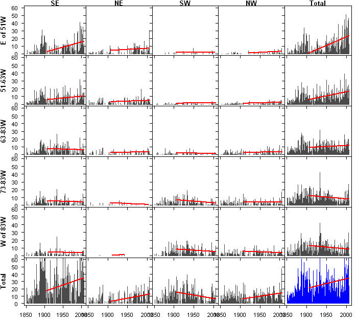
Figure 2. Atlantic Storm-days. Columns – 4 quadrants for hurricane origin adopted visually from Holland and Webster PPT and total; rows – 5 longitude quintiles for storm (winds exceeding 35 knots). Totalled across rows and columns. Grand total is scaled 0-120; all others 0-60.
So while it may be possible that the increase is climatological rather than technological, the evidence and analysis presented by Holland and Webster is far from proving the point.


26 Comments
How are the trends when the years before 1905 are included? I guess that there would remain no clear trend at all in the eastern Atlantic, whereas the slope of the trend lines would be negative in the western Atlantic. Such a pattern could not be explained by incomplete observation of storms in the eastern Atlantic.
A little opportunistic? Try deceitful. The 1900 Gavleston storm is excluded along with all the other inconvenient storms of the late 1800s. An attempt is being made to rewrite history.
HW concluded that there are data errors pre-1900. I agree (though the US/Canadian landfall data seems to have some amount of robustness).
My hope is that HW, having decided to exclude 19’th century Atlantic storm count data, suggest that same exclusion to Emanuel/Mann.
It seems to me that H&W should have just said that they believe reliable data do not exist for the period previous to 1905. That the existing reliable data do not give us a long enough view of “normal” conditions previous to those of modern times to establish a base from which to build any trends.
It seems almost obvious that the migration away from the American coasts is due to a better ability to detect and reach further.
While many of us had some fun with some of Ross McKitrick’s papers, I think that if he justified this data by a formula that depends on the GDP, illiteracy rate, and membership in the Soviet Union, he would be almost right in this particular situation. 😉
I put all the tropical storms and hurricanes into three buckets by 50 year groups. Then I divided each bucket into 6 smaller buckets according to the plot location in relation to landfall. This included location relative to islands. Here’s a matrix of the groupings with the numbers shown in storm days. You can easily see the 1951-2000 figures drastically increase at a distance of 240 miles.
Location,__1851-1900,__1901-1950,__1951-2000,___Mean

Landfall,___252.75,_____303.25,_____211.25,____255.8

1-120mi,____655.5,______1044.25,____745,_______814.9

121-240mi,__489.5,______534.25,_____527.25,____517

241-360mi,__256.75,_____245.25,_____396.75,____299.6

361-480mi,__118,________103,________222.75,____147.9

481-600mi,__95,_________90,_________220.75,____135.3

Total,______1867.5,_____2320.25,____2323.75____2170.5
Here are the same figures as a percentage of the mean.

Location,__1851-1900,__1901-1950,__1951-2000,___Mean

Landfall,___98.7%,______118.5%,_____82.6%,_____255.8

1-120mi,____80.4%,______128.1%,_____91.4%,_____814.9

121-240mi,__94.6%,______103.3%,_____101.9%,____517

241-360mi,__84.6%,______81.8%,______132.4%,____299.6

361-480mi,__79.7%,______69.6%,______150.6%,____147.9

481-600mi,__70.2%,______66.5%,______163.1%,____135.3

Total,______86%,________106.8%,_____107%_______2170.5
I may not have any statistical background. But anyone trying to tell me things are getting worse, better have a good explanation as to why the last 50 years of landfall readings, and readings out to 120 miles, are below the 150 year mean. That’s just the place I expect the readings to be most reliable. Are the storms smartening up and starting to avoid humans or something?
Here is a link to a .gif of a bucket within a bucket in case you may not quite be sure just what I did. I’ve got gifs of all of them.
This one is 1901-1950, 121-240 miles from land.

Hey! That’s great! Using the code tag keeps the columns in line. Next time I’ll leave out all those under-scores.
Re 6: Very nice analysis — and as you say very hard to explain except with the hypothesis that we have gotten better at detecting storms when they are further from their ultimate landfall point.
Bob, those are again very nice. What language did you use to produce these? Could you refer your landfall calculation? The gif code would be easier to read with a separator between groups – it’s formidable right now. But the example looks very pretty
Steve,
I do all my programming in Visual Basic 6. That has now gone by the boards more or less, but I’m too old to change horses. (no hope of turning 60 (again)) The matrix I posted started out as comma delimited, but I added the under-scores hoping to keep the columns somewhat aligned for easy reading. Too late I realized the code tag would have done that for me. If you want me to get the matrix to you comma delimited I can. I’ll use the code tag from now on when posting such things from now on, and save myself the extra manual labor involved with the alteration.
The landfall calculation was done by reading the color of the pixels on the map off of the screen. Once found, I interpolated that pixel to a coordinate and then calculated the mileage in knots between it and the plot coordinate to get the landfall distance. Essentially I walked a spiral from the plot pixel to every pixel around it, reading the color value until I found the shortest distance to land. I don’t know if you can do that with your program.
I have an algorithm to calculate mileage between coordinates on a spheroid. As you know not all coordinate distances are equal. It’s based on the FAI sphere used in aviation from what I understand. I can send you the code for that tomorrow. There are several different spheres, but it seems the differences are trivial.
Time for me to sack out. I’ll check in tomorrow.
The HURDAT Best Tracks files for the Eastern Pacific and Atlantic basins through 2006 are now available here. About 3/4 of the way down the page.
I guess this just proves I should read CA a little bit more regularly. I did the following write-up last week, but
it would have benefited from the discussion here:
Undercounting of Mid-Atlantic Tropical Storms
It is common to see claims that the incidences of tropical storms in the Atlantic basin are accounted for in the relevant database. For example, Kerry Emanuel has stated, “Tropical cyclone detection rates have been close to 100% globally since around 1970, when global satellite coverage became nearly complete 1. In densely travelled oceans, such as the North Atlantic, detection rates were probably reasonably high well back into the 19th century.”
Certainly, since the mid-1960’s when satellite coverage of the basin began, every tropical storm has been identified. However, in the period from 1900 until the mid-60’s it is not so clear. This note will attempt to show that the evidence leans to the conclusion that the storm databases seriously undercounts storms that never leave the Mid-Atlantic.
A Definition:
For the purposes of this study the term “Mid-Atlantic Storm” is defined as any storm that remains east of the 60 degrees west line of longitude.
The 60 degrees west line was chosen because it is close to the chain of the Windward Islands, the first land masses a Mid-Atlantic storm could likely encounter. It also seems likely storms to the east or north-east of this line of islands which remained there, would be the most difficult to identify and, thus, the most likely to remain uncounted.
Data:
For the purposes of this study I am using the Tropical Prediction Center Best Track Reanalysis (archived here). Specifically, I will be looking at the data from 1907-2006. This somewhat arbitrary selection gives me an even 100 years worth of data to examine. However, it seems no more arbitrary than selecting another date, say 1900, as a starting point because it also is a nice round number. An advantage to the dates I’ve selected is that it will give me 10 equal decades with which to make comparisons. (Note: The data for the 2006 season is not part of the raw Hurricane Database file, but was included from the Tropical Prediction Center Advisories.)
Mid-Atlantic Tropical Storms:
I first examined the records to see just how many Mid-Atlantic tropical storms there have been indicated. Fig. 1 shows the storms averaged by decade from 1907-2006.
.
Fig. 1
It is obvious there is a vast difference in the numbers of storms we see in the database. The era from 1967 to 2006 sees over three times the numbers of Mid-Atlantic storms when compared to the previous six decades.
A similar story is seen if we look at the same numbers as averages of all tropical storms. (Fig. 2.)
Fig. 2
From a low of 1.4% of all storms in the decade 1907-1916 (1 out of 70 total storms), Mid-Atlantic storms made up nearly 1/4 of all storms in the decade 1987-1996 (26 of 106 storms or 24.5%). One might claim these numbers represent the variability of storm incidence in the Atlantic basin, but it seems unlikely when you consider that the range can vary 30 fold. There was one (1) recorded Mid-Atlantic storm from 1907-1916 and 31 recorded for the time period of 1997-2006.
It is my contention that a good part of the difference in Mid-Atlantic storm numbers over time is due to the undercounting of Mid-Atlantic storm.
Hypothesis:
In order to test my contention that the discrepancies in the storm numbers are due more to undercounting as opposed to natural variability, I will look at storm numbers from the same time period that are not in contention. Namely, I will look at the incidences of U.S. landfalling storms and compare them to the numbers and rates we found in the Mid Atlantic tropical storms. If the differences are primarily due to natural variation in storm rates we would expect to find those rates duplicated in the landfalling storms. Conversely, if my contention is correct and there has been undercounting of storms we should find, at least, that the ratio of U.S. landfalling storms (or any subset thereof) to all storms was higher in the past (due to inaccurate Mid-Atlantic storm counts), and that the ratio will decline once better storm detection techniques are in place.
In order to have multiple points for comparison I divided U.S. landfalls into two categories. The first consists of storm landfalls on the coast of Florida. The second consists of storm landfalls on the coasts of Louisiana, North Carolina and Texas inclusive. The two categories have roughly similar landfall rates to each other so it seemed like a good match. In reality, it shouldn’t matter how I divide up U.S. landfalls (or even if I divide them) as we are looking for the rates of landfalls over time.
The next figure looks at the decadal average for land falling storms in Florida.
Fig. 3
As can be seen, the decadal average of landfalling storms in Florida is nearly equal when comparing the satellite years (1967-2006, 14.50 storms per decade) and the pre-satellite years (1907-1966, 14.67 storms per decade.)
For Louisiana, North Carolina and Texas the numbers tell a similar story:
Fig. 4
In this data the satellite years averaged 17.75 landfalling storms a decade, as opposed to 17.16 a decade for the pre-satellite years.
We do not find the large variation in numbers here that we found in the Mid Atlantic storms. This is suggestive of undercounting, but it could be argued that some closer examination of the data would find large known variations elsewhere in the Atlantic basin. This seems unlikely (to put it mildly.) In order to confirm that these results are probably due to undercounting, we need to compare the ratios of these landfalling storms to all storms in the basin. If other parts of the basin were experiencing more storms than we should find that the ratio of landfalling storms to all storms should be fairly constant over time. The data does not show that to be the case. (Figures 5 and 6)
Fig. 5
Fig. 6
As I consistently find that the ratio of land-falling storms to all storms is higher in the pre-satellite era, I am forced to conclude that the hypothesis is well founded. While I cannot say with 100% certainty that it is true, I am after all postulating large tropical storms for which there are no records, the basic logic of my approach seems inescapable.
Conclusion:
It seems very probable the Mid-Atlantic storm counts are undercounted in some fashion. It is a trickier question to determine the degree of undercounting. However, if we take the rates of Mid-Atlantic storms found during the satellite era (see Figure 2 above) and apply them to the pre-satellite era the results are startling. Broken down by decade, the percentage of Mid-Atlantic storms to all storms in the satellite era looks like:
1967-1976: 17.20%
1977-1986: 14.44%
1987-1996: 24.53%
1997-2006: 21.23%
and for the entire period:
1967-2006: 19.77%
If we look at the minimum (14.44%) and maximum (24.53%) values as defining a range for the pre-satellite number (which today sits at 40 Mid-Atlantic storms out of 495 total storms, or 8.08%,) we are left with a range of an additional 1.28 to 2.46 storms per year. That would mean a difference for the sixty year period of plus 77 to 148 storms.
Really, these numbers strike me as too high, but I do not see how to avoid them. One might postulate there is some new mechanism at work that is increasing the incidence of Mid-Atlantic storms during the last 40 years, but there isn’t such a mechanism described in the literature that I have seen. And based on my look at U.S. landfalling rates any proposed mechanism will have to apply to the Mid-Atlantic only. (It is for this reason that I have to reject the “Warm Atlantic” “Cold Atlantic” work of Landsea, Pielke, Mestas-Nuà±ez and Knaff, as being the answer, for such an effect would be basin wide and not limited to the Mid-Atlantic.)
Please note, this is a preliminary version of this study which will be added to and fine tuned almost constantly. Any comments or criticisms are most welcome.
Rich H.
In my estimation your reasoning is pretty much on the mark. Detection has greatly improved with the use of satellites. I think the 1851-1900 era would be shown to be the worst out of the last 150 years if they had the same detection ability as today.
In case you haven’t seen them, here are some animated gifs of the years 1851-2000 divided into three 50 year buckets that I linked to in another thread. Three frames each. About 3-5 sec. per frame.
T. Depressions
T. Storms
Category 1,2
Category 3,4,5
Emanuel’s statement about post-1970 detection of global cyclones is likely true with regards to strong, long-lived storms. His statement is probably untrue with regards to weak, short-lived cyclones.
This is because satellite technology is not static – it has improved over time. The improvements have come in orbit (geosync coverage), resolution, nighttime (IR) capability and features capable of imaging winds, rain and cloud structure. Today, meteorologists can analyze topical cloud masses with tools that did not exist just 15 or 20 years ago.
Here are the numbers of weak Atlantic tropical storms which existed for 24 hours or less:
1940-1949 (active decade): 2
1950-1959 (active decade): 1
1960-1969 (active decade): 5
1970-1979 (quiet decade): 3
1980-1989 (quiet decade): 8
1996-2005 (active decade): 14
Prior to 1940 such weak, embryonic, poorly-formed storms were likely undetected by ships or on landfall. They would have been experienced as squally weather.
Bob k.,
Thanks for looking my stuff over. (I’m not sure why my gifs didn’t appear over here..hmm.)
Your animated gifs are pretty convincing that there are serious deficiencies in the storms counts.
Actually they are the first things I’ve seen that point to the possibility that scores of storms
had been missed.
It also makes me think I should produce graphs showing directly the ratio of landfalling storms to
these east Atlantic storms, as that should be as visible as comparing them to the total of all storms.
David S,
Point taken. I’ll change what I write to be less categorical about the satellite era counts.
Now that full measurement of East Atlantic storm days seems to be in place, additional ways to increase the named TC count are more of a challenge to come by. What is left? One possibility is to start to name events and features which were, in past times, left unnamed. The seems to be some evidence that overly zealous forecasters, as well as, perhaps, some of the more cynical elements within the “killer AGW” faction of tropical cyclone studies, have embraced, over the past 10 or so years, a practice of naming, increasingly, features and events that, while not originated in the tropics, come, by various means, to exhibit certain characteristics reminiscent of true tropical cyclones of true tropical origin. In the 2007 season alone, we have witnessed Andrea, Chantal, and now, in early September, a feature off of the SE US coast, of extra tropical origin, is possibly going to be named. What can be done about this issue? I call it an issue because if we are to understand the record of tropical cyclones, and any trends concerning them, and statistics related to their occurrence pattern, we must have a rock solid way to avoid comparing apples and oranges.
I propose the following operational definition of a tropical cyclone. A tropical cyclone is a warm core cyclonic system, with winds above the break point for a tropical storm, measured to be sustained for greater than 12 hours at a six sigma level of certainty, that is of true tropical origin. Specifically, in order to be deemed a tropical cyclone warranting naming and inclusion in named tropical cyclone counts, the feature or event must have as its origin an Easterly Wave associated with the Inter-Tropical Convergence Zone (ITCZ). Furthermore, the feature or event must have achieved a tropical storm level of dynamics, as defined above, having directly evolved from an easterly wave. Easterly wave originated features and events which have been subsumed by, or merged with, extra tropical features and events, such as, for example, cold fronts, occulded fronts, warm fronts, mid latitude cyclones, mid latitude outflow boundaries, mid latitude sea breeze fronts, locally originated convective structures, etc, shall not be deemed to be “tropical” after said subsumation or merger. No feature which originated as a cold core cyclone, no matter how much it has been warmed, will be considered “tropical.”
Beautiful example of an occluded front with coupled mid latitude cyclone and parasitic warm front into the NE quadrant:
http://www.goes.noaa.gov/browsh.html
If I saw this off our coast, and it was sometime between Oct and May, I’d be waxing up my skis.
Doesn’t the ITCZ origin preclude defining many GOM storms as TS/Hurricane? If I recall correctly, Hurricane Allison in 1983 originated as a low near Florida and not from an ITCZ easterly wave.
RE: #17 – That is correct. Now, allow me to wear my West Coast bias on my sleeve! ….. 🙂
Here is a problem that, in the long term, could really wreak havoc with trends and stats. We’ve had a number of Allisons out here, none of them ever named. If we allow an Allison to be named, then lets name the one that knocked down my fence in early Jan 1996. Let’s name the great Sou’wester that smacked Seattle last year. In fact, for that matter, I am thinking about a Gordon Lightfoot song … heck, let’s name that too (I can even represent a Midwest bias as well!). The point is, if we want to creat a crystal clear, no debate Op Def, it needs to be very narrow and very black and white. Otherwise, finagling opportunities and issues with apples and oranges abound. As it stands, we literally have a barn door wide Op Def for the Atlantic, and, on some sort of self enforced basis, the ROW follows a much more narrow Op Def.
Of course, there is an alternative. Adopt a much more liberal Op Def, modelled after the de facto one that has been used sporadically in the past, and increasingly in the present, for Atlantic storms. Then, attempt to go back and scour the records, post hoc name and count features that were previously uncounted, and do a major restatement of the record, not only in the Atlantic, but world wide. In fact, doing so might be an interesting exercise, no matter what Op Def we end up with or accept.
Ooops…FWIW, it was Alicia in 1983…not Allison. I understand what you are trying to do, but I think it is an impossible task. If you adopt your proposed definition, then you have to try to go back and figure out the origin of every storm that hit the gulf and atlantic coasts prior to the time when we had satellites. For some you will be lucky and have ship reports, but for others you won’t. If you go liberal, then you are again handicapped by the lack of previous data on weak storms. I like David Smith’s criteria better, which relies on the length of time that a storm displays tropical storm force winds and tropical characteristics. Most of the Andreas and Chantals will be eliminated based on that criteria because they are very transient in nature and go back to extra tropical in a very short period of time.
OK, then what do we go about the counts for areas besides the Atlantic? Y’all have been counting apples, whilst we’ve been counting oranges.
So then, the liberal Op Def would be the most simple. But unless you get the world to agree to it, it will be a very regionally unique one (e.g. Atlantic only). I am harping on this for a reason. Up until about 10 years ago, Atlantic storms got all the focus. I can understand the practical reasons for that. But there is definitely a very Atlantic centric view as a result. And various practices as a result. We get Chantals and Andreas. The Europeans have named a few storms that were pure play mid latitude ones. We won’t make the “AGW = more TCs” concept go away. It will be exploited to the hilt. I agree that in reality, counting storms to try and make trends is BS. But this is the hand we are dealt.
I personally think each basin should be counted differently and a specific op def should be developed based on characteristics unique to that basin. But that would take the “global warming” issue and devolve it down to a regional climate focus that doesn’t meet the agenda needs of the warmers. Trying to come up with a trend for “global” storm counts that doesn’t take into account basin-specific cyclical oscillations and regional features such as ENSO is really pointless and I would rather spend my time vociferously pointing that out at every opportunity than letting myself get dragged into arguing the specifics of how to decide where the deck chairs on the Titanic ought to be arranged. If you believe the exercise of counting a global trend is unreasonable, then there is no point in trying to establish a reasonable methodology for doing it. The best bet is to propose an alternate regional methodology and then use it to point out the obvious flaws in any global counting exercise.
BTW, there should have been a wink or something after the snark in the beginning of my last post, but I figured you would recognize it as an attempt at humor and not me being rude.
This is pretty thought provoking:
http://www.aoml.noaa.gov/hrd/iwtc/Lander4-1.html
What I initially argued in #15 was definitely inspired by a subset of Circumstance 2. Since we cannot stop a certain faction from using TC counts as a climatological proxy, then so be it. However, here is the compromise. Restrictive Op Def. Anywhoo, enough keystrokes spent on this.
Herrrrrrrrrrre’s Gabrielle!
Whatever way you choose to categorise TC’s there are problems.
1) there is a continuum between tropical and sub-tropical with no clear dividing line.
2) ITCZ only origin eliminates many true tropicals and may include some hybrids / sub-tropicals.
3) excluding those starting off as sub-tropicals eliminates many that go on to become true tropicals.
4) there are significant variations between agencies for what constitutes a TC and categories of them.
5) instrumentation varies with agencies – e.g. 1-min vs 10-min winds.
6) the meteorological conditions for storm formation / support / intensification vary from basin to basin and with location in any basin and with surrounding meteorological conditions.
7) the WMO relaxed it’s definition a few years back shifting the goalposts more towards the US definition, creating yet another headache for historical researchers.
8) the Australian BoM has the best system … sorry, I could not resist adding that last bit, there have been many ‘ours-is-better-than-yours’ discussions over the years!
I submit that in 2005, there were likely certain NATL basin storms, that were not of ITCZ origin, that were not counted, and were, however, of types that during a “slow” year such as 2006 and seemingly, 2007, have gotten counted, as deemed “appropriate.” What a disgrace. A complete farce.