Here is a remarkable graphic from a new publication, Kent et al 2007, showing the distribution of SST measurements between buckets and engine inlets from 1970 on. I think that this evidence has great significance for the Folland and Parker SST adjustment, which is one of the most fundamental Team adjustments. I’ll discuss this more when I have time, but was struck by the graphic sufficiently to want to post it up immediately. I’m sure that some of you can figure out where this is going.
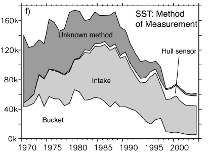
Kent et al 2007 Figure 2.f FIG. 2. Annual average numbers of observations per month in ICOADS for 1970—2004, stratified by the availability of measurement method metadata. The known methods for air and dewpoint temperatures and pressure [(a)—(e)] are all from Pub. 47, whereas those for SST [(f)—(h)] are from Pub. 47 or ICOADS.
References:
Kent, E.C., S.D. Woodruff and D.I. Berry, 2007: WMO Publication No. 47. metadata and an assessment of observation heights in ICOADS. J Atm Oceanic Tech 24. url
Folland and D. E. Parker, 1995, CORRECTION OF INSTRUMENTAL BIASES IN HISTORICAL SEA SURFACE TEMPERATURE DATA, Q.J.R. Meteorolol. Soc. 121, 319-367 here


60 Comments
Why so many fewer observations of late? Aren’t there more ships on the oceans these days?
Less ships actually. Air travel has taken away the passenger ships, and faster speeds means more goods can be carried by the same number ships.
Yes, the global shipping industry is in decline. There is a move toward fewer large ships rather than a larger number of small ships. A shipping line needs to pay fewer captains and cooks that way.
How do we determine where the ships are when the reading is taken? Present day, GPS, if tied in with the temperature logger, can provide very accurate positioning. But is this done?
How was it done in the past, and how accurate was it?
I’ve read that in recent decades ships travelling from the US to Europe use satellite imaging in order to figure out where the gulf stream is, so that they can catch a ride on it. Ships travelling from Europe to the US, travel well south of the GS anyway, so satellites don’t do them much good. From the charts that I’ve seen, one of the areas that show the greatest SST “warming”, is the N. Atlantic, precisely where ships, using satellites now spend more of their time in the GS, then they did in years past.
Looking at some of the old posts about arcane maritime intake technology, and the amazingly complex calculation of the expected difference in measurements between bucket types from first principles in Folland and Parker, it would seem to me that a better path is to compare statistical differences in measurement types across time and space, and see if an inference can be drawn about biases. Any thoughts on whether the data support this approach? Down the bottom-up, first principles path would seem to lie nothing but pain and argument.
re 4:
By means of celestial navigation
http://www.cse.yorku.ca/~amana/personal/navigation/
The figure shows about 60k observations per month, or 2000 per day. That is one observation per 183,000km^2 of ocean. Of course, large tracts of ocean probably aren’t being measured at all, and some are being measured much more than others – typical pinch points such as the English channel, Panama canal, Suez canal, straits of Malacca etc.
Steve M., that’s quite fascinating, particularly given this quote from the HadCRUT2 error analysis by Folland et al.:
Here is their graph of the uncertainties due to SST:
A couple of interesting points:
1) As the text says, the uncertainties drop vertically in 1941.
2) After 1941, the SST uncertainty due to bias adjustment (and presumably the bias adjustment due to buckets vs intake sampling) goes to zero.
This is in total disagreement with the graph at the head of the post, which shows that as late as 1970, at least a third of the observations were still being done by bucket, about 5% by intake water, and ~ 60% were unknown.
A further oddity. The HadCRUT2 error analysis says:
This jump of logic reminds me of the old story about a man standing under a street lamp looking on the ground. His friend says “What are you looking for?”.
“My keys”, he replies. “Oh, did you lose them here?”, the friend asks. “No, I lost them over there in the bushes … but the light is much better here.”
Their justification for using SST in place of air temperature is that there is “more useful data and smaller sampling errors”?!?? As a long-time sailor and commercial fisherman, I can assure you that sea and air temperatures are often quite different. This is particularly the case in areas where a change in SST causes the formation of fog, since much of the sea temperature change is taken up, not by a corresponding air temperature change, but by the condensation of water.
I have looked for the Parker et al. 1994 paper, but can’t find it online. It’s listed as:
If anyone has a copy and could email it to me at , I’d appreciate it.
w.
Ah, well, I left out the graph:
Rats.
w.
Perhaps, larger, more modern ships will also take in their cooling water from a deeper depth than the earlier ships.
Are the graphics disabled again? Mine aren’t posting
w.
It is certain that large modern ships take in deeper water at the enginer intake. They are bigger and deeper and because they are very wide, the intake will have to be low down to prevent air being sucked in when they roll. On top of that the engines are right at the stern and the hull turbulence will have ( I suspect) picked up a fair bit of deeper water. Which implies that the temperatures recorded will be lower than from buckets.
But if satellites are used to help avoid storms, they wil be sailing more often in calmer seas with less surface mixing. Which would bias the temperatures upwards..
Take your pick!
Bryan
Folks, you’re missing the punch-line. I’ll tell you tomorrow.
As Willis points out, what are you really measuring when you measure SST at any one point, and how do you translate each specific point to the desireable global average, if such a number is even meaningful? Then there is the problem with homogeneity of the measurments themselves, both in manner of measurement and geographical location and time, their spatial distribution and consequential non-random weighting. How can one put this all together and find a number that means anything? Are satellite measurments more helpful or a useful comparison? What is the level of sophistication and sampling of satellite measurements?
It seems like the only method that’s increasing in absolute or relative sampling rate is “hull sensor.”
This and “Intake” are probably now being measured automatically with a thermocouple-based temperature probe – not a thermometer. Thermocouples are very precise, but can exhibit drift in zero-offset absent calibration leading to questions about accuracy. The bias would not be preferentially up or down, but extra sig. fig. can breed false confidence in data.
I’m sure the hull and intake sensors on research vessels are well-calibrated, but I’d be surprised if an automatic sensor on a commercial ship was measuring the actual SST accurately, w/o calibrating to actual SST [like by running into an iceberg ! – SST = ~Zero C]
As I mentioned before, the HadCRUT2 temperature analysis says (emphasis mine):
Steve M. was gracious enough to forward me a copy of the Parker et al. 1994 paper, and I have not found a single word in it that shows that “this is the case” … in fact, they talk about having to make corrections for the previous use of canvas buckets to determine SST.
Why make corrections?
Well, because when the SST and the air temperature are quite different, the water in the bucket either heats or cools when it comes out of the ocean … which seems to me to indicate that SST is not a good surrogate for marine air temperatures. For example, they say:
Warm water and cold dry air hardly makes it seem like SST is a “good surrogate marine air temperature anomalies”.
w.
How is the Team treating the measurements made by an “Unknown method”?
They are mixing aples, oranges, pears and also some unknown fruit in their salad?
Steve says we’re missing the punch line and he’ll tell us today.
I have two guesses:
1) Folland and Parker hypothesise that the cause of the discontinuity in SST in 1941 (which is apparent as both a sudden warming and a sudden fall in variability) is a rapid changeover from bucket to engine intake measurements. It is evident from the Kent graph that this rapid changeover did not occur, since buckets were still accounting for ~30% of measurements three decades later.
2) a) the Kent graph shows a gradual increase in the proportion of intake to bucket measurements in recent decades; b) intake measurements risk contamination by engine heat; therefore c) there is a warming bias in recent data that Folland and Parker’s adjustments fail to capture.
Do I get the secret Caramilk, Steve, do I, do I?
I probably don’t because there are so many things wrong with these SST data and the corrections to them that I wonder that anyone knows where to start. Everything has changed, many times, over the 150 years of record. Ships, their motive forces, navigation routes, sample depth, bucket design, placement of thermometers, type of thermometers, measurement procedures etc. etc. etc. Trying to tease out underlying temperature anomalies to tenths of a degree from all this mess is just ludicrous.
Steve,
It’s time to stop teasing us now and tell us what you have found out.
Firstly though can I ask (as I’ve not seen any details on this blog yet which provide this information) what the relative contributions of land based and sea surface temperature measurements are to the overall claimed increase in global mean surface temperature since 1975? We’ve all read here all about the problems (reduced number of stations, poor accounting for UHI effects etc) with the land based measurements and it looks like Steve (to the disgust of the Wizard of East Anglia) is about to do another ‘Toto’ and reveal to us just how bad the SST measurements are as well.
Regards
KevinUK
Steve,
Do you have any data which extends the Kent et al chart above to the 1940 to 1975 period?
KevinUK
#19. your first point is substantially the one that I had in mind. However buckets accounted for about 90% of measurements where the method was known. Your figure of 30% would apply only if ALL the unknown measurements were engine inlet, which is inconceivable. I think that one has to estimate that about 90% of the measurements in 1970 were still being made with buckets.
Without bucket corrections, there is quite steep rise in SSTs from 1900-1950. That won’t do 😉
Click to access P_Nick_Rayner.pdf
Is Rayner’s article available somewhere for free? Journal of Climate wants money for Climate Change Industry, unethical to pay.
Dr. Robert E. Stevenson took bucket temperature readings in the 1960’s. He doesn’t have a lot of good things to say about the method.
SteveM, take a look at the SSTs in Figure 3 . Essentially no changes in 130 years. Stevenson’s observation that local warming in the parts of the oceans is in snyc with the 11 year solar cycle is quite interesting too.
The 21st Century Magazine has some interesting articles but what is with the Lyndon Larouche connection? That is not a particularly beneficial association.
The explanation given by Rayner et al. says:
Now, we know that the ICOADS dataset contains lots of bucket data … but that says nothing about the dataset used by Jones et al. However, Rayner et al. also say:
This sure makes it sound like HadCRUT which is a blend of CruTem (land) and HadSST2 (sea) data, is built on ICOADS.
Of course, to test it, they compared it to other sea temperatures which were taken directly in the ocean to avoid the bucket problem … just kidding, they compared it to a GCM model:
Hey, that convinces me … but all it convinces me of is that a pre-1941 correction is necessary, not of whether the correction should be applied to the post-1941 period.
Finally, the importance of getting the correction right is given by Parker et al.:
Sounds like Steve M. might have done the “further research” that Parker refers to …
w.
MarkW, March 17th, 2007 at 4:23 pm:
There were some ‘radio location’ methods available in the intervening years between the 40’s and the advent of GPS on the late 90’s.
.
Within 500 hundred miles of coastal areas by groundwave or 1200 miles skywave (with reduced or changing accuracy) of most developed areas a navigation system known in the UK as “DECCA” and the US and Canada as “LORAN-A” have been in operation since after WWII. LORAN-A was also implemented in many other parts of the world such as in the far east (and used until recently).
.
LORAN-C (100 kHz pulsed-emission hyperbolic ‘ranging’) replaced LORAN-A (1.6 to 1.8 MHz pulsed-emission hyperbolic ‘ranging’) beginning in the 1960’s. Complete phase-out of LORAN-A was accomplished by 1985 by the US with some station still in service in the far east. LORAN-C provided improved accuracy both night and day along with greater range capability (1200 – 2400 nm day and night) than LORAN-A.
.
DECCA was always a 70 – 130 kHz radio band-based system but worked by measuring the phase differences between continuous signals rather pulses (pulse delays) as LORAN systems do.
.
The early work on a world-wide position location system named OMEGA started in the 1950’s. In 1962 the US made the proposal to the ICAO and by the 1970’s enough of the eight ground transmitting stations were in place to make position ‘fixes’ with three stations being received. Accuracy positioning using Omega world-wide was plus or minus a couple of miles. US support of Omega ceased when the transmitters were precisely turned off at 0300Z on September 30, 1997.
Early nav systems – http://www.jproc.ca/hyperbolic/index.html
Full disclosure: I was with a firm in the late 70’s that had developed a compact, computerized ‘under-dash’ LORAN-C receiver for the pleasure boat and ‘working platform’ markets; the competition at the time was producing suitcase-sized LORAN receivers!
I might have missed the punchline but SST’ have been declining to 2000, whether which way it was measured.
Small world Jim. I used the Decca system in 1969 and 1971 while working with the Canadian Hydrographic Service doing survey work on the St Lawrence at Tadoussac and later on the Ottawa River at Deep River. We used a single Decca system for each boat and ran circles then shot transects with a theodolite and marked the depth. Fun time for an 18 year old. I don’t remember doing temperature work though.
Re 19: >>1) Folland and Parker hypothesise that the cause of the discontinuity in SST in 1941 (which is apparent as both a sudden warming and a sudden fall in variability) is a rapid changeover from bucket to engine intake measurements. It is evident from the Kent graph that this rapid changeover did not occur, since buckets were still accounting for ~30% of measurements three decades later.>>
Ten million tons of shipping were sunk around then, with fuel bunkers full of oil, light oil spreading immediately, and heavy bunker oil which would have leached out over the next couple of years. This must have had an effect on low level cloud cover. Maybe the sudden warming is what I’ve been looking for, the Kriegsmarine signal.
JF
This site http://badc.nerc.ac.uk/data/gosta/intro.html also has an extensive description of corrections to bucket SST temperatures. Scroll down to the discussion at and following Figure 6.
Re navigation
Pre fancy things like LORAN, Decca and GPS they would have used a sextant – like I did crossing the Tasman in a yacht in 1956 and the Pacific (on the Bounty – but without Marlon Brando) in 1961. Most ships would take a mornng shot, a midday latitude shot and an afternoon shot. In most cases, position would be +- 2 miles. Overall, and allowing for currents at night, they would usually know where they were to +- 4 miles. Good enough, I suspect.
Based on my experience in throwing buckets over the side, they would be in the water just long enought to pick up half a bucketful. If they get fully immersed in a ship that is moving above 8- 10 knots, you are likely to follow the bucket over the side. The sort of thing that only happens once..
Bryan
Pat F., that is indeed a fascinating site. I found the following quite interesting:
Some notes about all of this:
1) They distinguish between insulated and uninsulated buckets, which Kent does not do. According to them, all of the buckets in Kent’s data are likely to be insulated.
2) The reason that they don’t make adjustments post 1942 is that the measurement types are “inextricably mixed”, and because the average is small (-0.08°C). However, they also say that the adjustments range from -0.25°C to +0.2°, which seems like a large spread to me.
3) The size of the adjustment, as Parker observed, are based on the 1951-80 measurements, which themselves need adjustments.
4) They use a more complex adjustment than Parker et al., purporting to adjust for the winter/summer differences.
5) They say that the evidence that the SSTs pre-1942 need adjusting is that the SST changed with regards to NMAT (nighttime marine air temperature), and that there are “spurious annual cycles” in the pre-1942 data compared to 1951-80 (as shown in Figure 8, q.v.), with the difference being larger in winter than in summer.
6) But when I digitized Figure 8 and took a look, the smallest difference is in May, and the largest difference is in September … now I don’t know about you, but September is hardly “winter” on my planet.
7) From the text, the difference between winter and summer with insulated buckets vs. non-bucket is ~ 0.45°C.
8) From Figure 8, the difference between May and September with uninsulated buckets is ~ 0.8°C. If we take winter as D-J-F and summer as J-J-A, however, the difference between winter and summer is only ~ 0.2°C.
CONCLUSIONS
… I’m afraid I’m fresh out of those at the moment, except to say that the data doesn’t seem to support their conclusions … Me, I’d take a hard look at the NMAT data, because it seems more likely that there was a change in that than a change in the buckets.
But who knows? Another dark corner of climate science, to be sure, with more gaps in the data than data …
w.
This is all too typical of what passes for climate science. Let’s review the bidding:
1. SST became suddenly higher relative to NMAT temperatures according to Folland et al 1984 .
2. Folland hypothesizes an abrupt and universal change in SST measurement from buckets to engine inlets coinciding with American entry to WW2.
3. The adjusted results fit models OK.
4. No one actually checks documentary evidence to see if this happened, but data us adjusted on a huge scale on the basis that this hypothesis is true.
My closing point in the other thread was this – if 90% of known measurements in 1970 were still being made by buckets, the hypothesis that the sudden change in relative SST and NMAT levels in 1941 is due to an abrupt and universal change in SST measurement methods is disproved. Accordingly there is currently NO valid explanation of the sudden relative change in SST and NMAT levels in 1941 (if this is indeed a true characteristic of the data.)
I haven’t investigated the details and offer no theories on what might explain the relative change. Perhaps, as Willis suggests, it’s due to a change in NMAT measurement methods. But it’s not due to an abrupt and universal conversion to engine inlets in 1941. The Folland hypothesis is disproven and the Folland adjustment, as it stands, is invalid.
The optimistic confidence intervals for these measurements are absurd. The confidence intervals for the adjustment alone in the 1940s should be equal to 90% of the size of the adjustment.
Steve M., I agree wholeheartedly with most of the points. However, I think that what they are saying is not that there were no buckets post 1941, but that there was a wholesale change from uninsulated buckets to insulated buckets …
Now, the “uninsulated” canvas buckets in those pictures sure look insulated to me … and some uninsulated buckets were in use up to the ’60s, according to the one of the references.
Me, I don’t understand why these folks are using theoretical calculations, rather than just taking a thermometer, putting it in the ocean, then taking a bucket of water and putting the thermometer in that …
w.
How can you do that from a desk at the University? Honestly Willis, think of the practicalities…
I found this study about SST measurement. I skimmed it, but it seems to have some interesting info requiring a closer read:
Click to access 04minnet.pdf
re: #36 But Willis,
The problem there is the the whole reason given for the change was the danger of using lights at night, etc. But insulated buckets vs uninsulated ones would not be affected by such dangers at all.
Interesting that the number of SST readings also started to rapidly decrease in number since about 1989, same as the land station numbers/measurements, and from this one may conclude that the drop in stations has caused a global temperature rise.
I had no idea the USSR was that active in the SST measuring business before 1989.
And yes I purposefully wrote what I did in #29. Fisher I am not.
The British Atmospheric Data Centre says this:
>>information from the global SST climatology of Alexander and Mobley (1976), which includes estimates in data-sparse regions, was incorporated into the averages for 1951-80 presented in this Atlas. We recognize that their climatology is likely to be biased with respect to the true climatology for 1951-80, because it is based on analysis of data from a variety of earlier periods up to about the early 1960s, and these periods were, on a global average, probably colder (Folland, Parker and Kates 1984, Reynolds 1983). Further negative bias in their climatology is likely to have resulted from uncompensated changes of instrumentation, in particular the use of uninsulated canvas buckets until the 1940s (Folland, Parker and Kates 1984, Wright 1986), though the instrumental biases fortunately appear to be small in the Southern Ocean >>
Presumably those primitive Southern Ocean explorers kept using uninsulated buckets and didn’t confuse the records. Or maybe the unpolluted Southern Ocean didn’t change.
I was actually looking for data about changes in energy exchange between ocean and atmosphere during the 1940-45 period in the North Atlantic.
JF
from the link cited in 24, Dr. Robert E. Stevenson says:
“The first thing to remember is that the ocean is not warmed by the overlying air.”
“…greenhouse radiation from the atmosphere affects only the top few millimeters of the ocean. Water just a few centimeters deep receives none of the direct effect of the infrared thermal energy from the atmosphere! ”
“Consequently, anomalous heat associated with changing solar irradiance is stored in the upper 100 meters. The heat balance is maintained by heat loss to the atmosphere, not to the deep ocean”
is he correct? if so, then any increase we may see in SST cannot come from AGW, but an increase in SST from other sources (solar) will drive an increase in air temps.
Re 39, Dave, my understanding was that the change was from the inclusion of US Navy data post Pearl Harbor, and the fact that most? all? of the Navy ships used engine inlet thermometers … but what do I know?
w.
re: #42
It’s a little trickier than that. While it’s true that the IR from the atmosphere doesn’t penetrate very far, the ocean does have a mixed layer, which varies in thickness and so any heat which isn’t promptly used for evaporation, etc. will soon move to a depth of several to several 10s of meters. Obviously this will vary depending on how smooth the ocean surface is, what the wind is and other things.
Now as long as you keep the word “direct” clearly in view Dr. Stevenson is correct, but the statement could easily confuse the unwary. I would like a reference as to how much of the IR energy is used for evaporation, etc. as opposed to becoming equilibrated with the rest of the mixed layer. That would make it easier to decide just how important IR is to warming the ocean.
Actually I wonder how much heating of the deep ocean actually occurs since most of the movement of water to the depths occurs near the poles where melting ice, longs periods of dark, etc. can cool water enough that it has sufficient density to sink. But then it’s as cold as the depths anyway so what’s the difference? And if little heat makes it to the depths then the equilibration time for increased temperature from, say, increased CO2 won’t be that long. Note that this is different than the time to equilibrate human CO2 releases which can indeed move to deeper waters.
On the gripping hand, if it’s found that these cold gyres like the one just formed off Australia move warmer waters down as a side effect, then that could change things in either direction.
#44 Dave,
I am the confused unwary on this topic. I’ve re-read the article and still can’t a different meaning. Dr. Stevenson clearly says (I think):
1)the ocean is not warmed by the overlying air.
2)it is in those top few millimeters in which evaporation takes places. So whatever infrared energy may reach the ocean as a result of the greenhouse effect is soon dissipated.
3)several studies show no heat, solar or greenhouse, moves to the deep ocean.
perhaps you could show in his article where he’s wordsmithing to confuse us unwaries.
thanks,
jax
I agree with Stevenson.
The IR penetrates only a few microns (not millimeters). This puts it in the surface tension layer where convection is suppressed. Very little energy captured in this layer will be transported deeper in the oceans. More discussion can be found at http://www.warwickhughes.com/blog/?p=87
It is also important to recognize that this thin surface layer is cooler than the water in the mixed layer on average, so there can be no net transport of heat from a cool region to a warmer region.
Powerpoint by Reynolds on SST measurement, from 2003.
re: #45-6
I don’t accuse him of wordsmithing. I’m just saying that some of the heat will get incorporated into the mixed layer. The ocean does mix due to waves, wind and other factors. If someone has more details fine. You’ll note I said that I’m not at all sure any heat moves to depth. I’m sure I’ve discussed this before. It’s possible it was even on RealClimate back awhile when I posted there a few times.
You get off the hook since you qualified it with “net” but that doesn’t mean that the warmer region isn’t warmer than it would be if the cool region which is now warmer than before hadn’t warmed. And that’s what counts.
Also, when you’re talking microns, even if convection is surpressed, conduction comes into play. Frankly at this point I want to see the numbers. I’ll go look at what Warwick has to say, but I think I’ve seen it before.
Re #47 Powerpoint presentation
I look at the buckets on slide 10 and then imagine myself as a seaman. If it’s 1891 and I have that wide-mouth bucket at top, I’d tend to fill the bucket partially ( = sample the very top of the sea surface ) due to weight and drag. On the other hand, if I was using the later models (the smaller ones) then I’d likely dip a little deeper, as there is less weight and drag and the buckets probably sink a little faster.
Does that make a difference? Well, slide 19 indicates how temperature changes with depth. The profiles are qualitative, but they do indicate that temperatures in daytime with light winds vary on the order of maybe a degree C in the first half-meter of depth. At nighttime the trend looks similar but of a lower magnitude.
So, a sailor dipping a big bucket in the 1890s may tend to capture cooler water, on the order of tenths of a degree cooler, than sailors in later years, simply due to a slight change in depth of sampling.
It seems like that would be of a similar order as the evaporation effect but in the opposite direction. What a mess.
#49. David, I agree that it’s a mess, but doesn’t your argument show that the 1890s sailor might dip shallower (and warmer)?
Re #50 Well, my interpretation of Reynold’s slide #19 is that the very top layer is actually cooler than that a half-meter down. I presume that is due to evaporation at the surface. The water a half-meter down presumably gets sunshine but benefits from evaporation only via mixing.
If I’m using an 1890s bucket, I’m going to capture that very top (evaporatively-cooled) water. However, if I’m using one of the later (smaller) buckets, my arms are not as concerned with drag and would likely go a little deeper, maybe a quarter- or half-meter below the surface, where the water is a degree or two warmer.
Anyway, that’s my reasoning. I just see all sorts of sampling problems with buckets.
A general thought here on the SST measurements and the ground based weather stations. Clearly, neither of these was designed for anything more than a crude 1 or 2 degree measurement of temperature. Trying to extract anything more precise is going to be close to impossible because of all the corrections needed. In my experience, once your corrections are the same size as the signal, you have no assurance that you’re measuring a real signal. It’s time to design new equipment with errors 10% or less of the expected signal. Unfortunately no one has a time machine.
Allow me a philosophical consideration .
I have been working in industry for a time and there is a term “idiot experts” (Disclaimer : I absolutely don’t intend to appear offensive to anybody) .
Those are people who dedicated their life time to studies of particular very narrow segments
of science but who ignore the implication of their segment in a larger picture .
That is f.ex the case of a famous corrosion expert who after 2 hours of presentation is asked
the question “OK but WHY did the ship sink ?” and answers “I heard that there was a storm .”
The problem being that many debates about the AGW seem to be the field of excellence of this kind of researchears .
Nobody is able to explain let alone understand the globality of the system yet whatever subset of the system you choose , you will find an expert who has dedicated (or is going to dedicate) his life time to this particular subset and is unbeatable in proving that his particular theory on this subset is the only “right” one .
The “climate science” has an infinite potential to generate subsets because from thermodynamics to quantum mechanics and astrophysics everything is playing or assumed to play a role .
Then as long as somebody has the will and fundings to aggregate N subsets in a global numerical model , he will have infinite amount of work and support .
Of course the discussion about the “validity” of the model would be irrelevant because it is impossible to discuss it globally and by choosing subsets one falls in domains of “unbeatable” experts .
By reading this passionating thread I can very well imagine somebody dedicating his life time to the dynamics of interactions between buckets and liquids and providing his results as inputs to validate the Nth version of a numerical IPCC model .
It would of course still say nothing about the validity of the said models but would further contribute to the idea of scientific consensus aka even the bucket experts agree with AGW .
#49, #50
Wood floats. It’s a pretty safe assumption that the 1890s sailor dips shallow. Everything else is guesswork.
Bump!
For the benefit of SOD who seems to think we don’t audit the SSTs around here.
I’m not very sure he really cares. Or if he hasn’t already seen the information, processed it, and created an expert opinion about it.
45
My view is that he is substantially correct for 1 and 3. I’d add ‘much’ to # 1 (not warmed much by….). Re #3, the Navy has done extensive study of temperature in the oceans, because of sonar ‘channeling’, and there is extensive stratification of water by temperature to fairly good depths.
In #2, I think he’s is saying that the IR is absorbed at the surface and the energy dissipated by evaporative cooling before it can descend.
Re # 53 Tom Vonk
Hear! Hear!
Capsule microexperiments are not fashionable. Who today would leave his/her office and computer, take a couple of buckets on a cruise and compare temps with hull and engine intakes?
Models are fashionable. Why do that bucket cruise when you can elegantly model x^y parameters that have occurred to you over many years, and so smooth your data and error estimates that the boss would give you a medal for removing anomalies?
Real data can be substituted with imaginary. Blind Freddie knows that there are marked changes in vertical sea temperature profiles at a location, maybe an order of magnitude greater than the final model error estimate. When you don’t know, or don’t define, what you are sampling, why sample it at all?
Nature does not change, Man/Womankind does. The 1941 SST change cannot be ascribed to any bad personmade global activity, so it is smoothed out. The first hot decade of the 2000s is not made by Nature but by Personkind, so it has to be kept, even amplified. Personal experience: I was born in June 1941. In the early part of the year, it was fairly hot and wet. The latter part was cooler, so I had to drink a lot. And I was 12 lb 6 ozs when the temp changed. Include that in a global model, these are big numbers.
This is not science – even to the extent of making sunshine corrections to buckets of water at night time. Even to ignoring cold upwelling like the big one off NSW in the last year, omitting that each packet of cold that rises is balanced by a packet of warmer that sinks.
As we used to say, this subject is about as fruitful as kicking treacle. (For outsiders, a type of thick sticky syrup loaded with joules).
But I’ve written this before. Several times.
Re Navigation
How do submerged submarines take sun or star shots when under polar ice? How deep are their cooling water intakes? (Hint: It varies).
Very good point that some data might be selective or atypical because ships looked for both currents and winds to help them on their way.
I cannot get my mind around the principle of relating a constant (assumed) model wind speed relative to the cooling effect on a bucket of water. If I had proposed effects and solutions like that in my (serious) career, I would not have stayed in it for long. I’d be there dancing on the head of a pin with the others of like mind.
Now for a serious finish to this post. The more I read CA, the more aware I become that people who OUGHT to have certain data are simply not releasing it or talking about it because it does not fit their made-up minds.
One can be guilty of a sin of omission as well as one of comission.
What does the collective think of a list of matters where we suspect “inconvenient” data is being shuffled to the bottom of the pack? I can start with Phil Jones’ Lost Australian temperature data from his 1980’s publications and Steve might mumble something about Lonnie T, but I think there’s much more. You can often read its presence into guarded phrases and qualified sentences.
News: Some sudden shock at the Bali AGW circus turned Aust PM Rudd from a confident new winner to a frightened grey person almost overnight. Congrats to the public servants who had the facts more than the propaganda. I suspect more than one of the CA regulars would know some of them.
An interesting paper on the effects of World War 2 on SST measurement is here . It’s well-written and contains nice tidbits for history buffs.
8 Trackbacks
[…] Ocean temperature records: Discussed here and here. […]
[…] recent record is likely from the 1941 sea surface temperature (SST) adjustment. See here, here, and here for discussion of this adjustment. There is an abrupt jump […]
[…] several past posts here here here , I’ve observed that there is a very substantial and speculative adjustment of SSTs for […]
[…] forward to March 2007. I noticed the following remarkable graphic showing that, as of 1970, buckets were still very much in […]
[…] after publication of Kent et al 2007 showed the prevalence of buckets as late as 1970 (discussed here), I showed in a post entitled The Team and Pearl Harbour that this directly contradicted the […]
[…] Buckets and Engines […]
[…] Buckets and Engines […]
[…] Buckets and Engines, The Team and Pearl Harbor, Bucket Adjustments: More Bilge from RealClimate, Rasmus, the Chevalier and Bucket Adjustments, Did Canada switch from Engine Inlets in 1926 Back to Buckets?; […]