A couple of days ago, I reported on the comparison of Jones et al 1990 data to the TR055 data archived at NCDC, noting that the data was the same for all but one series. I’ve now been comparing the TR055 versions to GHCN v2 and HadCRU3 and noticing some puzzling aspects to both GHCNv2 and HadCRU3.
In a few cases, I’ve been able to closely replicate the HadCRU3 gridcell version from an individual station series (rather as I’d been able to do with some Russian gridcells.) Here’s one such example where the two series are virtually identical from 1950 on. You can tell this in two ways from this graphic: the GHCN version is plotted in black and the HadCRU3 version in red. If the two series match, then the later series overwrites the earlier – that’s why you don’t see the black GHCN series except for a little interval at the start. In order to show this, I then re-plotted th GHCN with points in large black points – their locations coincide with the HAdCRU3 version, so you can tell that the two series match over their recent history. The HadCRU3 version includes some early history not recorded at the station here.
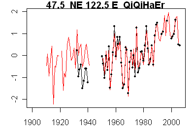
Black – GHCN version; red – GHCN version,
Haerbin is another case where the HadCRU3 gridcell value closely matches an individual station – in this case the match extends to the pre-WW2 portion as well. Shenyang is another close match.
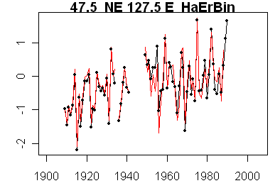
Black – GHCN; red HadCRU3.
While a few GHCN versions of Jones et al stations match through to recent values, I noticed that many, if not most, of the Jones et al stations were not recorded at GHCN after 1990, but HadCRU3 values in the gridcell continued to the present. Here’s one such example, where the GHCN station data for Qitai end in 1990, but the gridcell continues to the present. (In this and other cases, this is due to another station kicking in, but examining this phenomenon proved very surprising.)

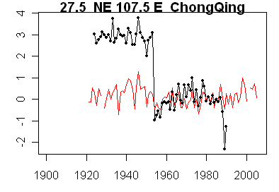
Yesterday I showed the large seeming inhomogeneity at Chongqing station. Today I’m going to show this station together with a station in an adjacent gridcell to illustrate the complications of post-hoc adjustments. On the left is Kunming station; on the right, Chongqing. The adjacent gridcells have quite different Hadcru3 histories (red) and one cannot avoid feeling that some amount of the difference is due as much to different adjustment strategies as to different histories in the two adjacent gridcells.
 |
 |
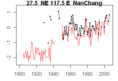
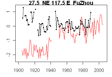
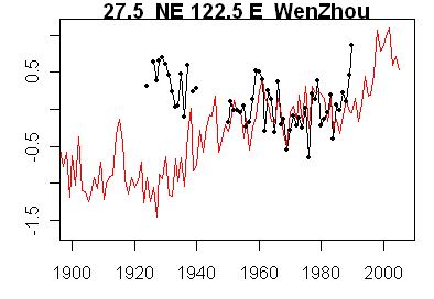
Another interesting case involving an entirely different adjustment strategy came in the gridcells 27.%N, 117.5-122.5E. Here are 4 GHCN versions compared to the HadCRU3 gridcell in red. For these two cells, the HadCRU3 version contains much lower early 20th century values than the GHCN versions for the Jones et al 1990 selected stations.
 |
 |
 |
 |
What accounts for the big discrepancy between GHCN station values and HadCRU3 gridcell values for these cells (and, since I’ve been able to more or less replicate some cells, my guess is that the difference lies in an adjustment to the data rather than in a failure to replicate some unreported and obscure aspect of the methodology.) More on this in the coming week. Also you’ll notice that several of the station series ended in 1990 (black dot versions). More on this peculiar phenomenon as well – it turns out to be pervasive in the Chinese data as archived at GHCN).


10 Comments
Check your script. Both the temperatures and and locations are off on the above charts.
Kunming is an interesting case. For long years, a backwater, at the southwestern margin of the “Middle Kingdom” proper, it was targeted for massive development after the Cultural Revolution. What made it important was its position in China’s southernmost province, Yunnan, which is astride the Mekong River and borders on panhandles of Myanmar / Burma, Laos and Vietnam. Over the past 10 years, a major superhighway has been built, north to south, which ends at the border with Laos and will eventually connect, as part of the UN/ADB promoted Eurasian Highway System, to the already existing superhighway networks of Thailand, India, Malaysia and Singapore. River channel and rail projects with similar goals are underway. Clearly, the plan is for Kunming, as the provicial capital, to become the main southern logistics hub for access to the ASEAN nations to the south. In addition to this significant development, there has also been growth in industry of all types. Tourism is also big, as the nearness to Tibet and other spectacular mountainous areas, plus significant cultural treasures, has become a big draw especially for people in other Asian countries. Population has skyrocketed since the late 70s and shows no sign of letting up.
#1. Bob K, everything’s OK. These are anomalies from a 30-year average, not an absolute temperature.
Steve M,
Re: “Also you’ll notice that several of the station series
ended in 1990 (black dot versions). More on
this peculiar phenomenon as well – it turns out to be
pervasive in the Chinese data as archived at GHCN).”
That isn’t a peculiar phenomenon in GHCN v2, and it isn’t
related to Chinese data as such. Over two thirds of GHCN V2
stations have not been updated in GHCN V2 since it was
published in 1997, and data for less than half of the stations
are included since 1992.
Imagine, if you will, that they did a really big scavenger
hunt prior to 1997, and collected data for many stations.
Afterwards, only certain stations forwarded data in a way
that would lead to that data being included in GHCN V2
updates.
One the other hand, if you look in GHCN Daily, which gathers
data in a different way than GHCN V2, you will find data for
recent years for several of the stations for which recent
data in not found in GHCN V2.
The grid starts at 27.5N 117.5E so if theyre going down and to the right, the other corner is at 22.5N 122.5E, is that correct?
(If so, thats an area of about 280,500 km, although Im using the distance between the points and then the calculation for a square (Stupid diagonal lines and trapezoids) to get it, so its approximate, rather than getting the length of all four lines…)
One thing I am confused as to why the .5 fractions above, I would think grid 1 would be something like 0N 0E to 5S 5E (or to 2S 2E in this case, since its all water in the Gulf of Guinea) and the numbers would all be even. Or do they start out some other way than 0/0?
Anyway, I wanted to print out some squares, plot the stations in it, and take a look at some of the stations in any given sector I was looking at. Does GISS or somebody already have something like that someplace already, or do you use a mapping program? Somebody must have it to figure out the grids. I might even write something to plot them and/or automate the area calculations with a bit of geometry to help. Unless it exists….
Thanks.
Sam:
Check Warwick Hughes’ site, he appears to have done this already for China and USSR.
Ah, the fractions are probably because each 15 degree slice becomes 9 land grid boxes but you need 2 15 degree slices to generate um 225 sea grid boxes? (rather than 1 slice to get 56.25 of them)
Plus the overlap?
Brings up another question, do they use the 2×2 if there’s any sea hitting land. I guess the issue is the sat SST combined with air land readings.
Arrggghhh!
Okay thanks bernie
Oh, I mistated the 15’s needed to make 225 2’s, you need 4 for “square” of 30 degrees.
Okay, some work’s been done here:
http://www.appinsys.com/globalwarming/
http://www.warwickhughes.com/climate/ and http://www.warwickhughes.com/climate/gridlist.htm
Some tools are here:
http://edgcm.columbia.edu/ EVA (and edgcm) and StationData.kml file
http://earth.google.com/download-earth.html
For example, LA grid cell (30-35N, 115-120W) which is about half water and goes into Mexico, is about 460kmx560km and has 11 stations. On Google Earth, the lat/long grid you can turn on goes in 30 second increments, so I kinda had to stick pushpins at the four intersections and draw a path to see it better, roughly a square. The one on the web site is older (Jones ’94) so the stations listed there are not the same exact ones shown on the above kml file (used by SurfaceStations).
I did plot out the starting and ending cells (grid on GE for land 10 degrees E/W and 15 minutes N/S; for sea, GE grid 5 degrees E/W and 15 minutes N/S if looking at the entire first two square stickpins for either)
So according to the info here and subpages:
http://www.ncdc.noaa.gov/gcag/gcagmerged.html
And now I remember, they do each (land and sea) seperately for the whole globe and combine them together as appropriate. They, ahem, explain the process in the papers and the web page. Sigh.
I did plot out the starting cells for land and sea. Land is 90N 180E to 85N 175E (and for that matter, the mirror of it, 90N 180W to 85N 175W, since 180E and 180W are the same thing, lol) It’s a triangle (surprise) 50km on the base and 560km on the sides. Sea is 88S 0 E to 86S 2E and is a trapezoid 8km on top, 16km on the bottom and 225km on the sides.
The sea “squares” start on land and the land on the sea, so they aren’t even used in the calcs!
I love it how they make all this so simple…. 🙂 I need to keep looking for a better method for this then doing it all manually and trying to recreate the calculations they used. All I want to do is find out the ratio of sea to land squares, and find out how many squares warmed vs cooled! Not go on a data hunt. 🙂
Oh, here’s the specific LA page. The graphic map he has there doesn’t go past the bottom of the US, so it’s not an entire 5 degrees
http://www.warwickhughes.com/climate/la.htm
I suppose I could start emailing the people with maps and ask where they got them/how they made them. (I know most come from papers and reports, but when I go look, I haven’t seen where it says they’re from.)
2 Trackbacks
[…] following receipt of the data, I did a number of posts at CA on the Chinese network e.g. here here here here here, analysis that we now know that Jones was monitoring. One of the few mentions of Climate […]
[…] on receipt of this information, I wrote some interesting posts on Chinese stations here here here . Doug Keenan followed up on this information as […]