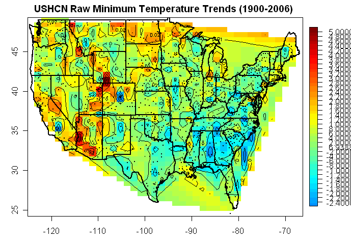
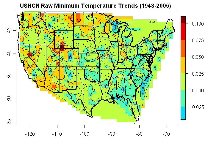
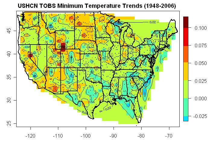
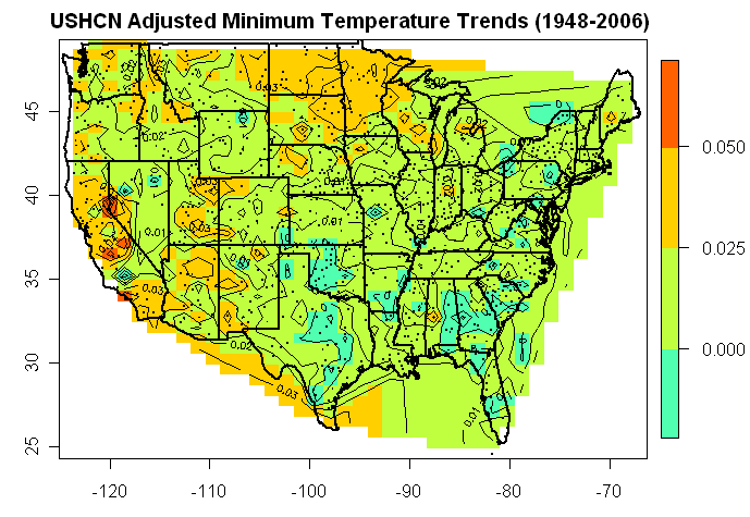
Here are 6 graphics showing contours plots of USHCN A) 1900-2006 trends for 1) raw 2) tobs 3) adjusted; followed by the same plots for B) 1948-2006 (same start as Parker) 1, 2 , 3 as before. The top 20 are shown for each case here. (Case A2 is missing because I forgot to save it, but it looks like A1).
Scale is deg C/year in all plots except the first one which is deg C/century (Sorry about the inconsistency.)


25 Comments
SteveM, I’m confused by the scales. Are those degrees C? Degrees C/decade? Also, it appears that raw Tmin data exhibit trends that are orders-of-magnitude larger than the adjusted data — is that correct?
Wow,
Interesting is it me or do the mississippi and other big rivers seem to
attract blue? despite development?
California maps make sense. Yosemiti park headquarter requires
Investigation. Recently, because of extensive human activity the
whole method of getting to the park is being re engineered.
Pasedena, santabarbara, Reno ( tahoe) Ojai, Fresno.. All ripe areas
for invesigation.
Now since Yosemeti Park is going under renovations There might be
very good detailed information in the EIR they prolly had to do.
Anthony, we had someone travel out that way a while back, yes?
Re#2
Anthony and I have collected information on sites around the Reno hotspot. Reno Airport may be a challenge due to security. Both the Reno and Lake Tahoe area have seen a lot of growth. Anthony has surveyed the Lake Tahoe site which appears to be in, or on the edge, of the hotspot.
I think that sonic has surveyed Yosomite Park and will be surveying the Fresno AP real soon now.
Ya Russ I was really stunned by the changes/growth in Reno. The airport Area
is just a concrete farm.
Yosemite charts
you’all go to UShcn and take a look. Sonic needs to get the survey done.
Back of the envelope the increase in Tmin is not “matched” by any like increase in Tmax,
But Tmin appears to have reached an Asymtope of sorts… Maximum vistors per year?
I think the park is up to 4Million a year
So, what happens in the “climate” that would drive Tmin but not Tmax.
maybe a better metric for finding Urbanizatin is this narrowing?
Steve M,
I suggest to draw a contour map of the 1980-2000 annual anomaly relative to the 1901-1930 annual station mean. That should highlight individual poor inhomogeneity adjustments, as the annual anomaly correlates well over 1000 km.
oops, another Steve M, I meant Steve McIntyre.
Sorry if this a bit off-topic (so feel free to move it), but – Steve – this post today at Roger Pielke, Sr’s blog deserves your attention. It concludes:
“The IPCC WG1 Chapter 3 Report clearly cherrypicked information on the robustness of the land near-surface air temperature to bolster their advocacy of a particular perspective on the role of humans within the climate system. As a result, policymakers and the public have been given a false (or at best an incomplete) assessment of the multi-decadal global average near-surface air temperature trends.”
One more thought.
Hypthosisis: at sites where UHI is absent, of at times in a sites history when UHI was absent or weak,
Tmax-Tmin would be relatively constant. Or of one looked at the slope of tmax and slope of Tmin for
a site, they would be roughly the same.
I suppose for the early part of the 20th century one could look at quality sites and test this.
( say orland)
On the other hand When UHI is present, the slope of Tmin increases.
Now, comes the question of how to make UHI adjustments. I’m not sure how hansen or Jones do it,
But one could argue that Tmin should be adjusted so that it’s slope matches Tmax slope.
If you Don’t adjust to this level, then you get maps that look like the ones above, or cases like
Yosemite, where Tmax is “relatively” stable and Tmin is climbing over time.
Doing this is somewhat akin to Peilkes suggestion that one only needs to look at Tmax.
make any sense?
N
Steve McIntyre,
May I suggest that in future trends you reserve the greens and blues for negative (cooling trends). Your use of green for the 0.000 to 0.025 range makes the plot look cooler than the data suggests. Maybe you should use white?
I wouldn’t want to see you accused of presentation bias.
Jeff
I’m using tim.colors from the package fields keeping the postive and negative breaks symmetric. It’s the best that I can do at the present time. It’s a standard coloring scheme and not my devising.
Re #9
Unless I’ve misread the paper by Quayle and Karl et al, circa 1990, which purports to reconcile the instrumental differences in the changeover from CRS measurements to MMTS measurements, the MMTS sensors produced lower Tmax and higher Tmin readings than the CRS units they replaced. Although this would tend to show relatively small differences in the daily mean temps, it reduces the diurnal range (Tmax-Tmin) quite significantly. Without appropriate compensation for this effect, using the diurnal range as some sort of measure for UHI effects would be compromised.
UHI effects in general derive from at least two components of the microclimate forcing; “passive” effects stemming from the thermal mass and radiational characteristics of the materials that make up the urban environment, and “active” effects stemming from heat generated by energy consumption within the urban environment. The effects of the former components would be dominant in semi-rural areas and especially the immediate vicinity of the sensing instruments and would be evidenced by the differences in the microclimate created by differing surfaces such as tarmac, concrete or grass and depending upon the materials involved would have different effects on Tmax and Tmin consistent with their thermal characteristics. Even the sign of their effects could be different.
On the other hand, the “active” components of urbanization would likely exercise similar influences day or night depending almost exclusively on the diurnal differences in energy consumption.
In the final analysis, the myriad of affective influences on a single point temperature sensor at a particular site almost demands that station data be evaluated on an individual basis and that consolidating and averaging UHI effects from a galaxy of temperature sites to create a mean UHI effect is akin to determining that someone can’t drown in a river that only averages 2 feet deep.
Since WWII Maine has seen a massive conversion to forest from farmland in the northern half, to the point where towns are being decertified. At the same time, the lower 1/4 near the seacoast has become part of megalopolis, all with nearly the same population.
Yosemite valley has always been the most popular National Park. A few years ago, due to the smoke in the valley, campfires were begun to be restricted to 4 PM till 10 PM. I would expect the min temp to decline at night with no campfires allowed then. Not an incinerator next to the probe, but a few hundred BBQs in the area. Also why would Reno be compared to Yosemite Valley for “corrections” since they are on opposite sides of the Sierra Nevada mountains?
Aurobo.
Thanks for the reply and reference.
you wrote:
“Unless I’ve misread the paper by Quayle and Karl et al, circa 1990, which purports to reconcile the instrumental differences in the changeover from CRS measurements to MMTS measurements, the MMTS sensors produced lower Tmax and higher Tmin readings than the CRS units they replaced. Although this would tend to show relatively small differences in the daily mean temps, it reduces the diurnal range (Tmax-Tmin) quite significantly. Without appropriate compensation for this effect, using the diurnal range as some sort of measure for UHI effects would be compromised. ”
I’ll read that paper over, but don’t disgree. My Notion, was to characterize a site prior to these types of
changes. So, for example, off the top of my head, look at the distribution of Diurnal range in the time period
of say, prior to MMTS. As you note, the instrumentation change resulted in a narrowing of the range.
When MMTS changes come in, of course, one would factor that change in. After MMTS I’m still wondering if the
Narrowing of range in the metric ( Tmax-Tmin) is a signal for UHI? Essentailly a rise in TMIN, a reduction
in TMin variance.
Going on:
“UHI effects in general derive from at least two components of the microclimate forcing; “passive” effects
stemming from the thermal mass and radiational characteristics of the materials that make up the urban environment,”
Ok, My question is does this pasive effect hit TMAX? Seems to me this changes the release of reradition
and hits tmin. just asking.
” and “active” effects stemming from heat generated by energy consumption within the urban environment. ”
Well, heat is heat, My “guess” was that UHI heat would Hit Tmin harder. Hmmm, why did i Think that?
Let me think some more.
“The effects of the former components would be dominant in semi-rural areas and
especially the immediate vicinity of the sensing instruments and would be evidenced by the
differences in the microclimate created by differing surfaces such as tarmac, concrete or grass and
depending upon the materials involved would have different effects on Tmax and Tmin consistent with
their thermal characteristics. Even the sign of their effects could be different.
On the other hand, the “active” components of urbanization would likely exercise similar
influences day or night depending almost exclusively on the diurnal differences in energy consumption.”
Ok, I have more thinking to do.. I had a different sense of things. I’ll read your reference.
In the final analysis, the myriad of affective influences on a single point temperature sensor at a particular site almost demands that station data be evaluated on an individual basis and that consolidating and averaging UHI effects from a galaxy of temperature sites to create a mean UHI effect is akin to determining that someone can’t drown in a river that only averages 2 feet deep.
Nevertheless, I would think ( absent the MMTS effect) that a narrowing of the Diurnal range would be an
unambiguous signal of UHI. Yes?
Note that most of the hot spots occur in arid areas. Where is that “positive water vapor feedback” that I keep hearing about?
Re #15;
In my experience with temperature data…mostly from CRS instrumentation …the princpal delta T,s between urban and rural areas occur on clear and calm nights where radiationally sponsored heat loss at the ground and other surfaces near and around the instruments is most effective. Urban exposures are almost universally less cold under these conditions as a much more complex system of absorption and reradiation from concrete, brick and other artifical structures prevails.
The most profound examples of radiational cooling can be found over snow cover on clear, calm nights. Snow is (ironically) an almost perfect black-body radiator with low thermal conductivity. The effect of its low conductivity makes it an excellent thermal blanket as it inhibits the capability of the snow surface having its radiational heat loss restored by heat conducted up from the ground. If dewpoints in the air above the snow surface are low enough, the nocturnal cooling process will continue right into sunrise. On such cloudless, calm nights s, the actual minima are usually reached shortly after sunrise. Why then? Because as the sun starts to heat the surface, some convective movement of air develops generating light winds, and this allows a portion of the very cold surface temperatures to rise to the level of the sheltered instruments (typically at 1.5m elevation).
During the daytime, the snowcover reflects a significant portion of incoming radiational energy skyward (or spaceward). Thus, even daytime temperatures are colder than their urban counterparts when there is snow. Over sod, the day/night radiational properties are quite different, preferentially absorbing energy in the red end of the spectrum and in the UV as well (the reason that grass is green). Grass is also capable of replacing radiational heat loss at night by drawing heat from the ground. Even so, they cool down better than concrete or other compounds with large thermal mass.
Finally, on windy nights, even in rural areas, radiational heat loss at the ground surface is mixed more deeply through the boundary layer and the sensible heat loss through radiational cooling is distributed through a much larger volume of air.
BTW, an UHI is by definition an anthropogenically caused temperature enhancement and no one has argued this in my lifetime. The real question is that on the planetary scale of things does this represent a significant alteration of climate. Can any geographer out there with a facility for pushing numbers, or finding data sources, tell me what percentage of the planet is urbanized?
RE: #17 – “The real question is that on the planetary scale of things does this represent a significant alteration of climate.”
My question would be different. “Does this represent an effect on surface measurements which would convey the impression of a significant alteration in climate?”
RE 17.
Fascinating. I’m off to a meeting but will come back to this.
On another thread I believe someone provided figures on urbanization.. Something like 2%
Check the Parker thread ( parker 2006 and urban myth )
I think it was there. Also, you’ll find my crude analysis of UHI
there. Please eviserate it, Do it on this thread if you like, as the parker 2006 is
winding down at bit.
Re #17;
To answer my own question; “…[W]hat percentage of the planet is urbanized?” The following appears in an article which can be found here.
#3. Reno is the #2 hot spot in the 1948-2006 TOBS trends after Rock Springs, Wyoming. It is used as a type case in the USHCN v2 preview.
Re #18:
Steve S gets right to the point;
Land stations by definition can only occupy ~26% of the Planet’s surface (the remaining ~74% being ocean areas. Subtracting out from that ~26% an additional (and considerable) percentage of uninhabited (and uninstrumented) land areas, then it would seem obvious that on the planetary scale these improperly named “global” surface station networks are clearly overweighted with urban areas.
RE: #22- They are overweighted toward urban areas, intensive agricultural areas, remote but dense outposts of civilization (e.g. mining, oil drilling, fishing, recreation, etc), military hubs, ski areas, areas near paved highways served by the electrical grid, and national park developed areas.
Yosemite data collection is very poor. The National Park Service is ‘too busy’ to read the instruments daily. Data now comes from a RAWS station which the NWS Hanford Office does not trust, particularly the max temps. Hanford continues to look for an observer.
Reno is warming because of the ASOS right on the runway…they moved the station there in the late 1990s. It is known as a hot spot.