In the discussion of my previous post, a reader posted a link to a fascinating picture of Tucson in 1923 – a picture complete with Stevenson screen in the foreground, if you can imagine, clearly visible on the right.
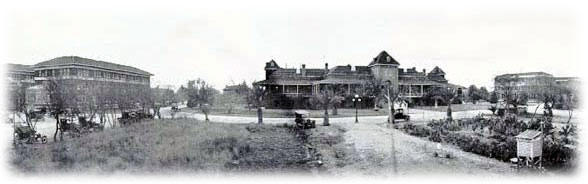
Figure 1. Tucson c. 1923. From left to right: Agriculture Building, Old Main, and the Mines and Engineering Building. Note the
There have been some ongoing discussions of Tucson stations at various blogs, originally initiated by the observation that the Tucson U of Arizona had the highest TOBS of all USHCN stations. I reviewed the status of this about 10 days ago, which has posted more jibes from Atmoz and others regarding the ASOS station at Tucson International.
Tucson International
In response to criticism of U of Arizona’s station a la asphalt, Atmoz originally posted the image shown below of the Tucson ASOS station – a picture which definitely gives an impression of a rural setting and adeuqate quality control.

Figure 2. Tucson Intl Airport ASOS station (from Atmoz)
I looked up the location of the Tucson airport in Google Earth and posted up the image below, stating that the location of Tucson International did not appear to be as rustic as indicated in Atmoz’ picture, adding the following caveat that this was under the assumption that I’d used the right location, about which I was not certain based on the information then available to me:
He did not show a Google Earth image of Tucson airport, which (if Ive got the right location), and the overhead gives a different impression than Atmoz pictures.

Figure 3. Google Earth overhead of Tucson as posted at CA on August 17, 2007
Atmoz then now responded that the location indicated in the above graphic was incorrect. In his post, Atmoz omitted the caveat in which I allowed for the possibility of an incorrect location and using climate science methods typical of Schmidt or Hansen, criticized me without linking to climateaudit. He showed the Google image shown below, arguing that this vindicated the original rustic impression that he sought to convey in his original picture and stated that “The airport ASOS is located over natural terrain”, making it appear, especially with the omitted caveat, that I had grossly mislocated the airport, a refrain picked up commenters at Tamino (commenters who do not cavil at Mann’s use of Paris precipitation data in a New England gridcell).

Figure 3. Tucson ASOS location as most recently posted by Atmoz.
However, the story is not quite so simple. I went back to Google Earth one more time to try to reconcile these pictures. Below is a wider view that encompasses both images. The ASOS station location is marked by the pin. It’s at the far end of one of the runways shown in the original overhead that I showed, slightly out of the original view, but hardly in a rustic location, as the station is surrounded by urban settings in all directions and is close to large asphalt runways (known to have an impact from the Asheville CRN experiment.) So yes, this site is slightly outside the original frame, but not by much, and it is hardly in a pristine rustic setting. Comrie included it as an “urban” site which he distinguished from non-urban sites and there is nothing in this wider overhead to cause one to disagree with Comrie’s classification.

Figure 4. Wider view of airport
The NOAA site description of this weather station (MI3) is rather amusing:
ON BROAD, RATHER FLAT PLAIN ON E SIDE OF SANTA CRUZ RIVER VLY 3.5 MI E OF SANTA CRUZ RIVER, ON S EDGE OF LARGE URBAN AREA, DRAINS NW. ASOS ON VERY FLAT LAND WITH SMALL GRASSY AREAS
I’m not sure that I’d say that this site can be presently characterized on being on the “south edge” of a large urban area. It looks well and truly encompassed in the Tucson urban area. However, I guess we can be grateful for small mercies: it is not classified by Hansen as an “unlit” site.


46 Comments
Jeff C was kind enough to post a link to the site as it exists today. Its been moved about 300 m SSW. Here’s a photo of the new site:
http://gallery.surfacestations.org/main.php?g2_itemId=12981
Here is a good oblique angle aerial view of the same location today http://local.live.com/default.aspx?v=2&cp=pc4sh05rmhtw&style=o&lvl=1&tilt=-90&dir=0&alt=-1000&scene=8696300&encType=1 . It looks like the Stevenson screen was on the mall area in front of the Old Main Building.
Comparing the 1923 photo to the current photo, I think I see the same cars parked there 84 years later! Maybe Atmoz can check that out for us…
The new site is located at approx. 1170 E 4th Street. Here’s an aerial view.
http://maps.google.com/maps?f=q&hl=en&geocode=&q=1170+E+4th+St,+Tucson,+Pima,+Arizona+85719,+United+States&sll=32.229693,-110.954082&sspn=0.001488,0.002511&ie=UTF8&ll=32.229708,-110.954254&spn=0.001488,0.002511&t=h&z=19&iwloc=addr&om=1
There’s a large white building that fronts E 4th. Behind that building is a parking lot. You can see the hashed area on the asphalt where the site sits. You can make out the fence and the Stevenson screen. If you zoom out, you’ll see the circular drive and the Mall area that helps locate the original site.
Here’s an aerial view from circa 1965 on sale at ebay: http://cgi.ebay.com/Aerial-View-University-of-AZ-Tucson-AZ-1965-Postcard_W0QQitemZ190012057833QQihZ009QQcategoryZ20196QQrdZ1QQssPageNameZWD1VQQcmdZViewItem#ebayphotohosting
There are numerous postcards from the past hundred years for sale on ebay, so performing a site retro-survey (at least for popular landmarks such as the UofA) may not be so difficult after all.
And here’s the circa early-1940s version: http://cgi.ebay.com/Air-view-University-Campus-Tucson-arizona-1946_W0QQitemZ190125766069QQihZ009QQcategoryZ20196QQssPageNameZWDVWQQrdZ1QQcmdZViewItem#ebayphotohosting
The Jesters, I like that!. Here’s the theme song for UHI.
If the investigators here are serious and want good aerial photographs of historical locations, they are available from quite a number of sources. Developing an aerial photograph history is part of any typical Phase 1 or 2 environmental site investigation (and they are used by multiple other organizations for other purposes). E-Bay is not a good place to look. It costs to buy them, but not a lot, and you are guaranteed quality and certification. You’ll have to research who sells such photographs in your area…
Was this posted before or am I just having a case of deja vue?
Re #9
Bits a pieces were posted in the comments section of the Tucson Detectives thread. I think Steve was jsut having some fun with the photo and the previous discussion got restarted.
Speaking of that, the NCDC station history log says the station was at the same site from 1898 through 1954. If the 1923 photo is the true USHCN station (probable but not definite) the 1946 photo linked in #6 would have the station on the far side of the Old Main Builing on the mall area. Notice how wide open the area still was in 1946. Nothing like the dense congestion of the present location.
I’ve added some notes on the weather station at Tucson International.
For good free 1 meter resolution aerials of much of Texas, try [url]www.tnris.state.tx.us[/url]
It is difficult to see how Atmoz could have got the background of his pic to look quite so rural. Apart from the fact that instruments seem to be obscuring some buildings and vehicles there is a lot of wide open space that is hard to reconcile with the overhead that Steve has used for location.
Can anyone identify the brown building on the left or the distant high ground on the right? It should be possible to identify the exact direction of the shot and the quadrant that is shown in the background.
I’m not suggesting that the picture has been edited – just curious.
#13
I used to live in a terraced house in densely populated area and lived there for the first 30 years of my life. One day there was a particularly nasty incident that took place nearby (approx 100 yards) and a national news agency appeared on the scene. They choose their camera angles so well that if I had not known better I would have thought that the incident took place in a quiet leafy upmarket suburb. Whoever came up with the phrase “the camera does not lie” was sadly mistaken.
#13
Google shows a lot of open space to the south of the site. The “wide open space” effect can be produced by using a wide angle lens. It tends to minimize objects in the backgroung and distort the apparent distance to them.
The fact that the instruments are laid out in a line gives us a good clue as to the orientation of the close up picture.
Looking at Steve’s picture, you can see a large white roofed building just a bit north of due west of the array. That’s probably the white building that you can see looking through the array. The brown building is probably the grey roofed building that is just south of due west.
I would guess that the picture taker is standing south east of the east end of the array, and is looking approximately wnw.
#17
Good point MarkW, I’ll look at it again.
#17
Looking at the shadows in the picture and zooming in in Google, I would guess that it is just the opposite: the picture taker is standing north of the west end of the structure looking toward the southwest. That view is parallel to one of the runways and misses most of the airport buildings.
Roman, you may be right.
The overhead shot shows a path leading off to the north.
The ground level shot shows what could be that path on the left side of the picture.
Mark, if you go to Google maps and look at the site at maximum magnification, you can see that the pattern of the gray gravel on which the equipment is placed and the small line of extra equipment in back on the right in the photo both seem to indicate that this is the case. It would be the direction I would choose to show just how the site is out in the wide open spaces.
Another view of the Tucson ASOS as a SouthWest 737 passes overhead and several F-16s taxi to the active runway. It’s a busy place.
A series of aerial photographs of the Desert View High School just northeast of the Tucson airport showing the area’s dramatic growth over 50+ years.
Overhead view via MS Virtual Earth. And a closeup.
This Google Earth view seems to suggest that RomanM is right. The hills in the background seem a good fit.
Most of the airport buildings, 1ncluding the main passenger terminal seem to have disappeared behind the instruments in this artless snap.
MarkW is right too; why is nothing that comes out of climate science quite what it seems.
Sorry to have have started something that doesn’t really add much to the topic Steve posted on.
I live in Tucson and have looked at the site. The closeup photo of the instrument array appears to have been taken looking South-east , almost directly down the main runway. The nearest buildings are probably to the left of this picture at a distance of hundreds of meters. The hills seen in two of the photos are probably the Rincon mountains 15-25 miles (24-40 kms) away (depending on the viewing angle) that are over 8,000 feet (2500 meters)in altitude or perhaps the Whetstone Mtns that are directly off the end of the runway at about 35 miles (56 kms)distance and 7300 feet (2200 meters) in altitude. The immediate general terrain is flat. The site is at the southern edge of the Tucson metropolitan area but there are some developments to the West and South of the site.
Having lived out that way in the early 90’s, I can confirm that the area to the south of the airport was largely undeveloped during this timeframe. Atmoz photo is clearly dated Aug 96. The Airport sits on the south side of Tucson, south of I-10 next to the Tohono Oodham Indian reservation. Davis-Monthan AFB (and the airplane graveyard) are just north of the Airport on the other side of I-10. Any view of the southeast would have been largely unobstructed. The “story” is quite different is almost any other direction, which is why I believe Anthony Watts 360 degree photos are much better than a single photo.
Note that there’s a second picture at Atmoz’ site taken from here (Which may have further clues) http://www.wrh.noaa.gov/wrh/staffnotes/120105internet.pdf
A bit off topic, but: putting inaccuracies in surface temperature measurement aside for the moment, satellite lower troposphere temperature data show little temperature increase trend in the southern hemisphere (0.07 degree per decade) but an increase of 0.22 degree per decade in the northern hemisphere. [http://vortex.nsstc.uah.edu/data/msu/t2lt/uahncdc.lt] Could direct heat transfer from urban heat islands, far more plentiful in the NH than the SH, to the lower troposphere be the cause? Has anyone done the math?
Nice oblique aerial views of the ASOS site from four cardinal points are available at maps.live.com. Perhaps someone with better skills can post a link.
Re 29 RWP:
Here is the link you requested. It is similar to that posted above but without pointers to all the airplanes.
#27 Steve M
That bloody Hansen guy gets everywhere. He’s even relasing weather ballons theses days.
KevinUK
I know most of the acronyms used around here, but could someone please verify what TOBS is for me…is this Time of Observation? Thanks.
Time of Observation Bias
Thanks MarkW!
Wouldn’t the coming and going of all those jet aircraft raise the nearby temperature, both acoustically and via engine exhausts? What part of the UHI effect is attributable to high levels of ambient noise?
Meanwhile, in Phoenix, the papers are trumpeting record-setting temperatures: http://www.azcentral.com/news/articles/0829HeatRecord0829-ON-CP.html
John #35:
We need to quantify a UHI trend effect, not just a UHI effect. So a potential important data requirement for all airport locations, beyond the standard microsite influences, is growth in take-offs and landings. This should also be done on a daily basis to see now interday and intraday variations influence the temperature record. It would make a pretty good thesis topic for a graduate student.
Steve: [snip – if you want to make a point, fine. But don’t complain about snark, and then throw around insults. I don’t make comments like this to people who post here. ]
Atmoz has fabricated a picture that he ascribed to me. Atmoz states the following together with picture shown below:
If you compare this picture from Atmoz with any of the Google Earth images shown above, which collate the image from my earlier post, you will see that none of them contain the green arrow inserted here, which Atmoz says is my flawed attempt to locate the ASOS station within the Tucson airport. The green arrow in this picture is not mine, but a total fabrication by Atmoz.
In my first Google image of Tucson airport, I made no specific attempt to locate the ASOS station and expressed a caveat that I might not have the right location for the airport. In the image in this post, the ASOS station is located with a yellow pin in a different location than Atmoz has shown here.
A. He put that image up in response to me, because I asked for it. I was Google Earthing to make sure that you and he were at the same airport. Your and his earlier pland views did not overlap at all (they are about a frame away). I was able to find a view on the net that showed both together but unable to cut and paste it. I asked him to paste one that showed both the terminal and the ASOS (in otherwords, both the plan views).
B. It is RIGHT that he is “INCORRECT”, in ascribing a green arrow to you as locating the ASOS. He should say that this is where your plan view was, to be precise. He did not fabricate an image. He put an incorrect green arrow up.
C. It’s outrageous (misleading…and I would say it to your face, sailor) that you posted the terminal image as indicating the condition of the ASOS when you had not even confirmed the ASOS as in screen and when the airport OBVIOUSLY has lots more open land than shown. It’s also dishonest (Clintonian failure to respond) that you did not answer my queery on where the ASOS was (even supposed to be) within your image, and that you did not correct the commenter who said that it was in the lower right.
D. You STILL have not addressed this issue on the original thread, and instead have an MSM-style rowback slipped into a post with a different subject (and after it was originally posted). Very passive aggressive, Steve.
Not sure about google earth, but the green arrow is standard in google maps when one searches for a location. I would never ascribe the green arrow to indicate a manual identification unless it were explicitly stated, just that it identifies where google locates the information searched for.
I did not have a green arrow in any of my images. He inserted a green arrow into an image that I had used and then said that I had located the ASOS station where the green arrow was, specifically discussing the green arrow. Sorry, TCO, attributing the image with the green arrow to me was a fabrication.
His original post also omitted an important caveat where I explicitly said that I was uncertain of the ASOS location, pretending that I had purported to say something that I didn’t.
In this particular case, I remain unconvinced that my original point was incorrect – the ASOS station at Tucson International Airport is not in a pristine rural station. Yes, it’s not located in a parking lot, but it’s located fairly close to large asphalt runways at a large urban airport. Yes, if you dial back up, you can see desert to the south of the airport, but you see urban developments in other directions and immediately around the airport in most directions.
If I had actually said without qualification that ASOS station was in a spot where it wasn’t, I would have edited the various descriptions based on further information without a second’s thought. I don’t claim to be omniscient about details of Tucson geography or anything else. Even if I made such an error, it wouldn’t prove that auditing studies like Mann’s or Hansen’s is a stupid thing to do; it simply shows that people make mistakes and that articles should be checked – my articles as well. I try to be careful but, quite frankly, given the amount of material I’ve posted here, I’m surprised that I’ve made as few mistakes as I have.
I’m going to guess that TCO’s next response will be, that until someone can determine, to his satisfaction, what affect a runway will have on temperature readings, out to a thousandth of a degree, we must assume that it has no affect.
RE 43.
There is a VERY instructive test that one can do.
Collect Giss raw for UNIV Tuscon. 1880s to present
Collect GISS RAw for Tuscon Int Airport 1948 to present.
Collect GISS RAw for Tombstone Az about 1904 to present ( when you junk missing years)
If a global trend is present at Univ T. the same trend should be at the airport
and it should be at tombstone only 100KM away.
Another thing to look for is differential heating or cooling. Jumps.
So, you look at Univ T – Airport. and you look at Univ T – Tombstone…
You will find some interesting discontinuities… in 1955 and 1998.
I was in Tucson last week and visited the Univerisity of Arizona. Let’s put ourselves in the shoes of the NWS. Where should they move the station where it would be free of UHI and local micro climate effects? Keep in mind that the station has to be within 5 miles of the original location and about the same elevation.
My opinion is that moving the station would be impossible given the requirements. There are not many places in Tucson where WMO requirements could be met. The electric companies like where it is currently sited because it represents Tucson very well. This station should be dropped from climate change determinations.
re 45.
No problem with that Virgil.
We need to quantify a UHI trend effect, not just a UHI effect. So a potential important data requirement for all airport locations, beyond the standard microsite influences, is growth in take-offs and landings. This should also be done on a daily basis to see now interday and intraday variations influence the temperature record. It would make a pretty good thesis topic for a graduate student.
2 Trackbacks
[…] the frame of the Google Earth image shown above, which I responded to in a separate post on Aug 22 here, from which the comments below are […]
[…] Atmoz in his continuing effort to argue that the above post contained a scandalous error, as I reported here, Atmoz then fabricated a variation of my original graphic in which he inserted a green arrow that […]