As an exercise, I’ve plotted the locations of the GISS Code 1 stations in the US, color coded them to show the ones that end early and then examined the Code 1 stations in California where there is a combination of both a strong GISS trend anomaly and station survey completion.
First, here is an interesting diagram from Hansen et al 2001 showing 1900-1999 trends based on “Unlit” stations – showing results for different USHCN versions. I presume that the interpolation here uses something like the R package akima, which I used in a plot last year. For now, don’t worry too much about the differences in trends for the different USHCN versions – just notice the hot spot in southern California, as that’s what we’re going to look at in more detail.

Next here is a plot showing the location of all the Code 1 stations in the GISS file, color coded so that blue ends by 1990 and red goes after 2000. A couple of things to notice here – first, none of the GISS Code 1 stations in Canada or Mexico has any information after 1990. C’mon, Jim and Reto – get off your LaZee-Boys and get the data. So to the extent that post-1990 information affects the Hansen two-legged adjustment, it is all from US data.

Next here is a zoom-in showing the stations that would presumably contribute to the southern California hotspot. There are only 10 of them. Since Hansen has identified them as Code 1, I guess that we can interpret that as some kind of voucher that these stations are the crème de la crème of U.S. stations, that here we will find the distilled essence of station history at its finest, NASA’s top guns.
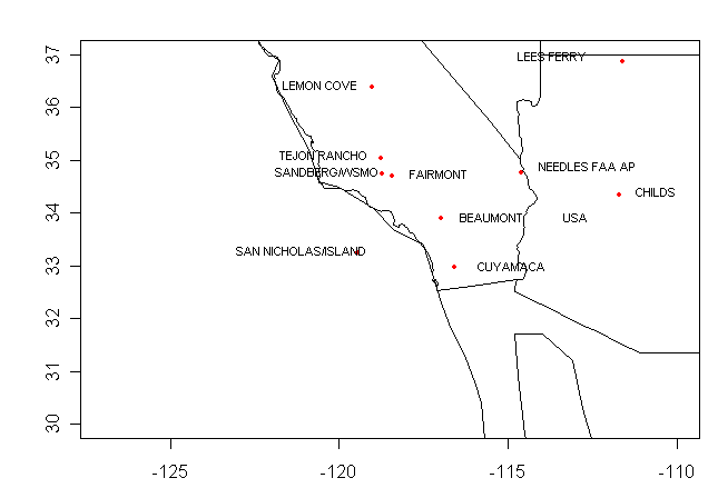
NASA’s Finest
Cuyamaca:
Cuayamaca (surface survey here) is station nearest the SW California corner – let’s work up from here. Cuyamaca has the temperature history shown below. I’ve shown the 1900-2000 trend per Hansen et al 2001 together with a trend from 1925-2000 in green. There is actually a slight decline in the 75-year period, though there is a noticeable trend in the 100-year history. (Post-2000 values are not included in this analysis because they were not available for Hansen et al 2001.) The station history notes a move in 1926 – see dashed red line. The trend for this station thus depends on what we know about Cuyamaca station in the early part of the century – do the low early 20th century values represent well-measured temperature or is some portion an artifact of station moves?

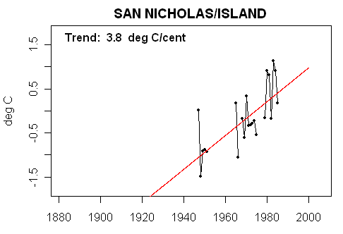
San Nicolas Island
This is an offshore location, which is in GHCN but not in USHCN. Observations, as indicated in the history below, are spotty. This seems like a peculiar selection as one of NASA’s finest as the record is extremely discontinuous. Surely there are better alternatives.
Beaumont
This is another non-USHCN (ending in the 1980s) which is a peculiar inclusion as a Top Gun. It appears that there may have been a station discontinuity around 1940. As it is not a USHCN station, there is no station history so it’s hard to tell. The available information obviously is not strong support for Hansen’s hot spot, support for which must obviously be derived from other Top Guns.

Sandberg
Sandberg is another non-USHCN site included in the Top Guns. As shown below, it only has a short squib of a record and it’s hard to see why it should be accorded Top Gun status.

Fairmont and Tejon Rancho
These two sites are near each other and shown below. One has a slight increase since the 1920s, the other a slight decrease. One has no early 20th century values, the other has lowish values along the lines of Cuyamaca, and opposed to Beaumont.
 |
 |
Lemon Cove
Lemon Cove has a long history again with little trend since the 1920s, but low early 20th century values generate a 1900-1999 trend.

Needles
Needles, another USHCN site, is the last Code 1 site in southern California. It has a long history and considerable visual similarity to Lemon Cove. In the late 19th century, it has quite high values, but it also looks like there is a discontinuity.

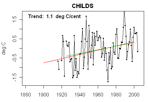
Childs AZ
Childs is one of only two Code 1 sites in Arizona (the other is Lees Ferry in the very north of Arizona.) Hansen uses distances up to 1000 km (625 miles) for weighting though the weight declines with distance. Because it is relatively isolated from other Code 1 stations, it has a very strong influence in Arizona – an area that we’ve discussed at some length. It has rather low values in the 1930s, a pattern opposite to Needles and Lemon Cove. One wonders at how solid this information relative to the leverage of the site.
Lee’s Ferry
Lee’s Ferry has a still different appearance. Values before 1940 are similar to values after 1940. The post-2000 pattern is different than Childs and one wonders whether there is a discontinuity at one site or the other.

Some Comments
While I endorse the concept of trying to find quality within the USHCN network and I think that they can be identified with objective criteria, I’m not convinced that the GISS unlit methodology has developed a very good network of Top Guns in the southwest U.S. Obviously some of the Top Guns have very spotty histories and should be disqualified on those grounds alone. Once they are excluded, we are left with a rather small population and it’s relatively easy to do some QC on each site. On a quick pass, it seems unlikely that all of the sites could have been properly QCed and that the remaining differences are climatic. It seems far more likely that there are still material QC problems with the Top Guns in southwest U.S. and that 1900-1999 tend quantification (a la Hansen et al 2001) is to a considerable extent far too dependent on QC issues.
The 1900-1999 trend is extremely dependent on the pre-1920 portion of the Code 1 record and, in this case, the early part of the century is highly dependent on only a few stations, with one of the stations (Beaumont) having very inconsistent results to the others.


56 Comments
Many of the stations you list I have already surveyed at surfacestations.org Some are visible with live databases but have not been surveyed.
Here they are:
Tejon Rancho http://gallery.surfacestations.org/main.php?g2_itemId=696
Lemon Cove http://gallery.surfacestations.org/main.php?g2_itemId=654
Fairmont http://gallery.surfacestations.org/main.php?g2_itemId=638
Cuyamaca http://gallery.surfacestations.org/main.php?g2_itemId=628
Needles FAA AP http://maps.live.com/default.aspx?v=2&cp=psv4nm5ffn54&style=o&lvl=2&tilt=-90&dir=0&alt=-1000&scene=84743&encType=1
The NCDC MMS database is down again, so I can’t locate some of the other remaining few active ones yet.
Tejon Rancho is a good site, long record, virtually unchanged in 100 years.
Fairmont looks good, but I’d point out it is next to a reservoir which fluctuates dramatically, and has had its extents changed during the station history. Likewise, so is Cuyamaca next to a reservoir
Lemon Cove is in the middle of an giant lemon orchard, wind sheltered and in proximity to ag operations. Needles is between the access road and the runway.
The stations I listed aren’t urban (except for Needles), but they have their issues.
If it’s in the middle of a giant lemon orchard then it’s readings for lows were distorted by smudge pots, burning used tires and wind machines every time the temperature dropped near freezing. That was standard agricultural practice in the Central Valley among citrus growers beginning immediately after the first crop losses due to frost occured. I would guess that would have been right about the time the name “Lemon Cove” was adopted.
For the Urban adjustment The GISS code 1 are combined to create a continous series.
Again from memory, the sites are sorted from longest record to shortest, then if they dont
have 20 years of overlap with the Urban station ( code 2 or code 3) then they are dropped,
then they are avergaed in with a 1/range factor to create an Rural “trend”
So, the rurals get blended ( with range weights) that the the Urban is subtracted from this
and so you get a Bias…
Make sense? I’ll diagram it out a bit later.
Have you updated the detail.dat file to relect the code 1?
re 1. Last time I looked at Lemon Cove was when I was studying the PARKER UHI paper.
Parker used the Fresno Airport ( not the univesity) for his site. As I recal there were two
predominant wind patterns. ( duh) one coming in from the coast and the other blowing out from death
valley area..The temp differential for these two conditions was noticable.
Lemon Cove, I recall was immune from these effects.
How does this station list look with the Google-nightlights business?
Steve, my suggestion in the Googling the lights fantastic thread was to compare the list you use in this thread with the list that would be obtained by using the B=A/B/C flag. That list would be obtained if the statement in the code was activated.
Maybe the B=A/B/C flag, since it come with the NCDC/NODA data file might be the way USHCN/GHCN decide if adjustments are applied or not?
That jump in the 20,s for some of the stations is intriguing. When did the stations start using the thermometers that automatically mark min and max?
remove and re-post in appropriate thread if required but related to global temperature

Hudson bay
http://arctic.atmos.uiuc.edu/cryosphere/IMAGES/recent365.anom.region.13.html
but latest time lapse
http://arctic.atmos.uiuc.edu/CT/animate.arctic.0.html
so overall sharp drop in last 24-36 hours as shown in main
same with Hoshtosk ice (compared with most recent time lapse doesn’t make sense. Don’t mean to be picky but can someone check?
Hard to consider this a non-biased source anymore in the light of this as well
http://arctic.atmos.uiuc.edu/index.html
http://mikelm.blogspot.com/2007/09/left-image-was-downloaded-from.html
october 2007. Hope it is an honest mistake
RE 9. It’s in the Distribution. so you can get it as a text file and then parse it.
Step0 input files V2_inv
The documentation appears to have changed on this.
But the mystery remains.
If you look at the USHCN file format the last two feilds are not there.
SO, there is a program somewhere and data source somewhere that adds these two things
to the station INV. and further GISScode is added someplace
Re #8:
This current (23 Feb 2:41PM CST) depiction of Hudson Bay shows 90-100% ice coverage.
RE 9. Its hung me as well.
The ushcn ftp at ncdc went down today ( which has this file)
The nasa earth observatory which has descriptions of nightlights went down today
and now this nasa file is hanging me up.
Weird.
Another weirdness. HERE is what the original program has
10160355000 SKIKDA 36.93 6.95 7 18U 107HIxxCO 1x-9WARM DECIDUOUS C 49
10160360000 ANNABA 36.83 7.82 4 33U 256FLxxCO 1A 7WARM CROPS C 12
HERE is what I could download before getting lynched
10160355000 SKIKDA 36.93 6.95 7 18U 107HIxxCO 1x-9WARM DECIDUOUS C
10160360000 ANNABA 36.83 7.82 4 33U 256FLxxCO 1A 7WARM CROPS C
NOTICE something missing? brightness index.
Since my browser is hung halfway through This, I will draw no conclusions. weird.
—ID—- Legend: cc=country-code
P: R/S/U=rural/sm.town/urban (population)
N: 1/2/3=dark/dim/bright (satellite light data 1995, only near cont. US)
B: A/B/C=dark/dim/bright (part of GHCN’s inventory file)
PNB brightness-index
200460003 GMO IM.E.T. lat,lon (.1deg) 806 581 R A cc=222 0
200690003 OSTROV VIZE lat,lon (.1deg) 795 770 R A cc=222 0
202740000 OSTROV UEDINE lat,lon (.1deg) 775 822 R A cc=222 0
202920005 GMO IM.E.K. F lat,lon (.1deg) 777 1043 R A cc=222 0
203530000 MYS ZELANIJA lat,lon (.1deg) 770 686 R A cc=222 0
206740006 OSTROV DIKSON lat,lon (.1deg) 735 804 R A cc=222 0
207440000 MALYE KARMAKU lat,lon (.1deg) 724 527 R A cc=222 0
207440001 MALYE KARMAKU lat,lon (.1deg) 724 527 R A cc=222 0
208910006 HATANGA lat,lon (.1deg) 720 1025 R A cc=222 12
214320004 OSTROV KOTEL’
When i used to do orbit determination we had multiple tracking data segments from multiple stations and multiple orbits that we used to compute the trajectory. We treated each individual observations and didn’t attempt to build a modified station record with multiple passes and make corrections. Each individual set of observations had any corrections applied to it individually then we attempted to computed the orbit and mathematically determined it. Least square fits were obtained and the residuals were carefully looked at. Our stations didn’t move or change equipment like the temperature record does but satellites had burns and atmosphere friction would change orbit and at the point we would recompute the orbit.
My belief is that the attempt to combine station temperature records for each station into one continuous record for that station by itself is introducing uncertainty into the process. Each station record segment should be individually used in the process of obtain the change in the slope of the temperature record and the slopes then combined using a least squares method to get the final world temperature trend
Excerpt from post #141 on the “Another UFA sighted in Arizona” thread:
RE20, hey good for Eric! He got one right.
Ya know, its my bad, I read it but didn’t remember it.
It seems to me that the whole idea of a station “move” is wrong. What makes a station a unique station is its location, right? So when a station is “moved” wouldn’t it be more accurate to say that a station has been removed and a new station has been added? They seem to be dealing with stations being discontinued anyway, so why treat it as something special when a new station is near where an old station used to be?
Steve Mc,
Adding the bristlecone universal teleconnection site to that blowup would be rather amusing. Maybe a graphic of a radio tower with the waves emanating from the top.
GISS Global Stations In Google Earth
Readers of several of the recent posts by Steve and Anthony may find the following information useful. I just did a Google search and not too many people appear to be aware that this facility exists. If it is old news I apologize.
Ken Mankoff, of the House of Hanson, has a Google Earth implementation of all the GISS stations which is outstanding. All of the hot-spots, cold-spots and incomplete data are graphically rendered in living color, with trend lines for the last 10, 25, and 50 years for each station. This resource is very useful in identifying where the problem stations are located.
When you load the KLM file into Google Earth, note how the US and CA border is clearly delineated by the condition of the Canadian stations. In the US there are a number of bright red pins which are screaming for the extra TLC which only Anthony can provide!
Before you down load the KLM and/or KLZ files, read the following documentation. The must have file is StationData_net.kmz which can unzipped to StationData_net.kml, but I would download everything. This is an excellent learning aid.
Documentation for Global Temperature Station Data in Google Earth
http://dev.edgcm.columbia.edu/wiki/StationData
Public pages of Ken Mankoff at Columbia/GISS:
http://edgcm.columbia.edu/~mankoff
Folder containing all of the GISS Station data for Google Earth:
http://edgcm.columbia.edu/~mankoff/StationData/
This small Google Earth KLM file links to the larger KLM file:
http://edgcm.columbia.edu/~mankoff/StationData/StationData.kml
This large Google Earth KLM file contains all the GISS station locations:
http://edgcm.columbia.edu/~mankoff/StationData/StationData_net.kml
This is a ZIP version of StationData_net.kml which Google Earth can read directly:
http://edgcm.columbia.edu/~mankoff/StationData/StationData_net.kmz
ZIP StationData_net.kmz StationData_net.kml
This folder is where all the generated Postscript images are stored.
http://edgcm.columbia.edu/~mankoff/StationData/images/
This folder is where station data though 2006 is stored:
http://edgcm.columbia.edu/~mankoff/StationData/data/
While the above folder appears to contain data through 2006, many of the station graphics in Google Earth appear to be complete through 2007. I suspect that updates are being made from the primary database.
This tabulation of the GISS stations may be useful:
http://edgcm.columbia.edu/~mankoff/StationData/data/v2.temperature.inv.txt
#18. Amusingly Mankoff contacted me last summer for information about my scraped versions of GISS data. It seems that he had to scrape station data as well and was interested in looking at what I’d done. I offered to give him my results, but he went and did his own scrape, I guess, and I didn’t hear from him any more.
RE19 Mankoff also contacted me about using surfacestations photos in the project, to which I agreed. But then he wanted me to modify the format just for him, which I said I couldn’t do easily. Later I offered a format that was a compromise which would have allowed him to convert into what he wanted with a little work and he still insisted I had to do it his way. He then launched a bit of a stereotyped slight on RC about me, for which I asked for and got an lukewarm apology. Needless to say, between that and format demands, I haven’t pursued any further collaboration.
Like with Steve Mc, I haven’t heard from him again.
What an absolute demolition! Yet, surprisingly, a relatively straight-forward one.
The US climate network is increasingly looking like a perpetual motion machine. They all look impressive; on a first pass, you’d think the second law had been cracked…Scratch the surface, however, and the flaws appear faster than an ageing film star.
This kind of thing (along with Anthony Watts’ effort) are invaluably important, because global warming theory and practice starts from one, fundamental proposition: that the Earth is warming, because our most accurate measurements prove this, as an incontrovertible truth.
If the accuracy of the measurement is implausible, every assessment which proceeds from that point (with precision) is an illusion. A toss of a coin!
Steve,
Very strange that Ken Mankoff should request the scraped data since he is using a government Email account [Ken Mankoff (mankoff at giss.nasa.gov)] all over his website and is obviously connected for Dr. Hansen. Did Ken Mankoff use his government Email account to contact you? The second contact for the product is Mark Chandler (mac59 at columbia.edu), who is using a Columbia University Email account.
The project is EdGCM (Educational Global Climate Model) and is documented here http://edgcm.columbia.edu/. Ken and Mark are quite the globe trotters, read their travel logs; but, this is the travel season for the Antarctic. The EdGCM project objectives are described here http://edgcm.columbia.edu/about/project/edgcm.html and Mark Chandler is Project Director.
Google has quite a bit about the project itself:
http://www.google.com/search?q=%22Educational+Global+Climate+Model%22
http://www.google.com/search?q=EdGCM
But almost nothing about GISS Stations in Google Earth product.
To be very honest, I stumbled across Ken’s project when I was attempting to construct a Google Earth map of the Antarctic Stations. When I was unable to find the data I required at the official GISS website, I did a Google search looking for specific types of data and Google found Ken’s project for me. When I realized what I was looking at, I was flabbergasted.
The earliest data/time stamp on Ken’s public folder is July 24, 2006:
http://edgcm.columbia.edu/~mankoff/?C=M;O=A
So this project has been ongoing for some time now. The GISS Station data was moved in bulk from somewhere else on or about August 28, 2007 as all the data/time stamps are the same.
The EdGCM is promoting their climate modeling software for students all over the place but keeping a low profile about the Google Earth Station Data. I did the following search for EdGCM and “Google Earth” and found the following:
http://www.google.com/search?q=%22Google+Earth%22+EdGCM
My original post to Climate Audit late yesterday evening is already one of the top ranked pages in Google for this search! Most of the Google Earth products related to the EdGCM project are in support of the modeling software, such as this one:
http://edgcm.columbia.edu/downloads/ge/EdGCM.kml
The programming for the GISS Stations in Google Earth is fantastic and Ken Mankoff has to be one outstanding programmer. So why isn’t the EdGCM promoting this product? As I reviewed the problem stations in the United States and the abysmal condition of the Stations in other countries, from my virtual perch 500 miles in the sky, I answered my own question. The historical data which the modeling programs use is predicated on a Global Potemkin Village.
I have a question about the “corrections” that Hansen applies that led to the first 4 images. What feedback does he use to prove that his corrections are actually improving things? You can’t just filter out noise from a system in an arbitrary way – even a way that sounds plausible – without some way of knowing what to filter. Specifically, you filter data to remove noise to bring you closer to some “reference” data. For the urban bias correction, what is he using as his reference? For filling in gaps, does he run some controls for pairs of stations with lots of intermediate stations to show that his filling is correct?
The reason I ask is that it’s interesting that the raw data show a slight cooling, but after all the corrections, it’s almost 1/2 degree warmer. It’s amazing that the noise signal is so biased. Given that this signal is probably generated by a lot of random things (e.g. taking temps at different times of the day), I would’ve expected almost purely white noise, in which case there should be no real trend. But Hansen seems to have evidence of a strong negative bias to the noise signal, and he must’ve arrived at that experimentally somehow, but I’m just curious how.
I’d like to throw out the hope that the GA Tech visit will encourage more participation from people like JEG and maybe some from the hockey stick class. I know Judith Curry posts often, but usually on more big picture issues. I’d like to hear from “the other side” of the argument on this particular issue. Is this a case of “nipping at heels” or does it show up some real problems? If so, what do we do about it?
I think John V. is the only real believer in this forum who really digs in and puts his view on things… or at least used to.
On the Gogle light thread, Ellis noted the following from Hansen:
These kinds of adjustments seem highly problematic and suggest that it will be impossible to reconstructr the aadjsutments to some station data.
RE 24. For a long time here and at RC I complained about this paragraph in H2001.
First I want everyone to understand the math. Hansen removed A “portion” of Norcal records
that showed STRONG COOLING in the early 20th century. Now pause and think about this.
This actually diminishes the TRENDLINE from 1900 to today. He did not remove these stations
to create a larger TREND in warming. He removed portions of the record because the trends
of the rural sites didnt match the SST trends or the periurban trends or the Urban trends.
If he left a A cooler past intact would mean a Bigger trend. So These deletions have nothing to do with creating an enhanced trend. They are just a curiosity.
I looked at Lake Spaulding in the time period Dr. Hansen excludes. The site undergoes a near linear cooling. This is indicative of a nonclimatic change. A sensor going bad, or as one reader pointed out, a resevoir being built in the area, changing the “climate” in that area. It was clear to me by looking at lake spaulding and the surrounding sites, that
lake spaulding might be broken during this time. I believe he excludes everything up to 1926.
I looked at Electra and crater lake, Orleans and Willows. there were some geographical considerations for each of these which would explain the relative cooling to the rest of the area,
But nothing as clear and forceful as the Lake spaulding cooling. What I wanted to see from
Hansen2001 was the exact math of how these sites were identified as anomalous and subject to
data circumcision.
Here is the Issue.
The records of certain sites are shortened. There is only a paragraph explaining
this and no supporting data. The change is inconsequential. But the documentation
of the analysis is incomplete. When I looked at Lake Spaulding, it was “clear”
that the early part of the record was an outlier. That’s me Eyeballing it. I want
to see H2001 METHOD for objectively determining this. It makes no difference to the
final outcome ( a few years removed from 1 station) But I want to see the method.
Then there was Crater Lake. As Anthony can tell you, H2001 elimation of this site
made no sense whatsoever to me. It’s TREND data is not much different than nearby sites.
YES its colder in absolute terms because of its elevation, but trend wise, it matched up
pretty well against its neighbors. At least that is my subjective assesment.
Point being: if you remove an observation record, you need to document it completely.
Bottomline: Hansen eliminated portions of station data, and in the case of Crater lake an entire
record. That is fine, PROVIDED you supply the data and methods and decision logic used
to make this decision. If he included this data, almost nothing would change. That’s not
the point. The point is: what method did you use to decide this? What test did you perform
what cutoff did you establish. The answer is right, but he needs to show every step.
Re: #21
Hold back a little, Brad. Finding flaws in some of the surface station measurements doesn’t call into question all observations of global warming. The warming in the Arctic is incontrovertible-this is not some kind of instrumental anomaly. And there are just too many other measurements that support each other: radiosonde data, satellites (including cooling of the stratosphere), animal migrations and extinctions, glacier mass balance, sea level rise and acidity, etc. And there is no mystery why this is happening – man has drastically changed the fraction of CO2 in the atmosphere. This is solid science.
#21, 26. I emphasize over and over to readers not to go a bridge too far. Just because some things are done poorly doesn’t mean that all evidence is flawed. I, for one, believe that it is warmer now than in the 19th century and for that matter, I think that it’s probably warmer now than in the 1930s. It’s fair to evaluate each line of evidence to try to establish how much weight can be used for each one.
Erik, if someone is charged with preparing a proper temperature history, then I think that they have an obligation to do a good job on it. Just because the Arctic is warming doesn’t mean that GISS should fail to collect Canadian historical data after 1989 or that they should not carry out elementary QC on their Code 1 stations.
I think that a network of “good” stations will show warming. It’s annoying that Hansen’s QC has been so inadequate.
I found Childs, AZ station, at a “power plant”.
From NCDC MMS:
A look at Google Earth says it is in a river valley, so likely on a dam.
The imagery is too coarse though to make out any structures. The imagery matches the topo description:
Looks like they switched to MMTS in 1985. Location appears unchanged since 1948 except for a location update for more precise lat/lon in 1998.
RE original post, I don’t see a 1926 move for Cuyamaca (coop 42239) in the site record. MMS only goes back to 1/1/31, and indicates a move of a few seconds in 1/23/98, plus two changes in elevation, in 1954 (from 4672′ to 4652′) and 1972 (to the present 4640′). The Surfacestations survey includes a Commerce dept form saying the station goes back to 8/10/1887, but it doesn’t mention any moves. (Tobs has been 0800 since 1/1/0000, so there should be no TOB adjustment).
There must have been a move when the dam was built, but maybe that was 1931? There was also a Cuyamaca Rancho station (42241) at the Paso Picacho Ranger Station, 1987-2003, but that should be a separate record.
Erik, #26, even solids sometimes sublimate.
==========================
#29. I have a copy of the older CDIAC history http://cdiac.ornl.gov/ftp/ushcn_monthly/station_history which appears to have some details not present in what you picked up here. Here is summary of Cuyamaca moves, sorry about the ragged format.
begin_date dist_prev_loc conf_dist_move dir_move elev_chg hgt_chg obstime_temp CRS DT MN MX MMTS
1 08 10 1887 NA 0 999 4800 99 0 0 0 0 0
2 01 01 1899 NA 0 999 4670 10 07 0 0 1 1 0
3 01 01 1915 0 0 000 4670 10 18 0 0 1 1 0
4 02 01 1926 0 0 000 4670 99 18 0 0 1 1 0
5 04 03 1933 0 0 000 4670 05 08 1 0 1 1 0
6 03 30 1939 0 0 W 4670 05 08 1 0 1 1 0
9 02 01 1963 0 0 000 4650 05 08 1 0 1 1 0
10 04 13 1972 0 0 N 4640 05 08 1 0 1 1 0
11 05 20 1982 0 0 000 4640 05 08 1 0 1 1 0
12 12 31 1985 0 0 000 4640 05 08 1 0 1 1 0
13 07 08 1992 0 0 000 4640 05 08 1 0 1 1 0
The primary issue with me is the quality of the data that is used in the calculations. Going up, going down, I don’t care. But the data must be valid.
Can anyone give me an example in which measured data are modified based only on the relationship of that data to other ‘nearby’ data?
The only situations that measured data might be changed with which I am familiar are 1) adjustments for rigorous calibration standards and 2) for measured, demonstrated, and quantified unwanted side effects; radiation effects when measuring a temperature, for example. For a 2-D fluid flow field I don’t think measured data are ever changed based on comparisons with other nearby data. Generally you live with what has been measured, assuming the experimental setup has been properly designed, constructed, and operated. It is possible for measured data to be totally screwed up, but in those cases the experiment is abandoned following very careful review of all aspects of the system.
Does anyone have examples of measured data being changed?
re 32. on another thread I made the observation that if you have 100 random samples
and you use 50 of them to adjust the other 50, you are left with 50 random samples.
Here is a thought. Look at the warming trend in sites that DONT need a TOBS adjustment.
Rather than make an adjustment based on a model, select those stations with a consistent
TOBS.
I took the Lake Spaulding Survey. This site has two certificates for 50 and 75 years of service, and I took pictures of them, but could not locate the pictures this morning on my computer. The caretaker estimated the site has been in place for about 90 years at a location near the caretakers cabins. According to the COOP record at WRCC the site was established in 1902, the dam was completed in 1912. Precipitation data starts in 1912. However the meta data shows the temperature data is only available from the July of 1948 to May of 2003, when the sensor was moved closer to the dam.
Here are some views from the Surface Station Data base.
Location of Sensor relative to dam here
Site near caretaker’s cabin here
RE32 Dan Hughes,
Yes, Cedarville, CA rural, lights=0, dark, long station history, yet GISS modified.
see it here:
http://wattsupwiththat.wordpress.com/2008/02/17/cedarville-and-giss-adjustments/
26 Erik Ramberg says:
“Hold back a little, Brad. Finding flaws in some of the surface station measurements doesn’t call into question all observations of global warming. The warming in the Arctic is incontrovertible-this is not some kind of instrumental anomaly. And there are just too many other measurements that support each other: radiosonde data, satellites (including cooling of the stratosphere), animal migrations and extinctions, glacier mass balance, sea level rise and acidity, etc. And there is no mystery why this is happening – man has drastically changed the fraction of CO2 in the atmosphere. This is solid science.”
You can always tell when you’re getting close to something the AGW’ers don’t want to discuss: They bring out “THE LIST”.
I do want to comment on your first line, though: “Hold back a little, Brad. Finding flaws in some of the surface station measurements doesn’t call into question all observations of global warming.”
Then tell us, after looking at 4 different temp anomaly charts, with different data and processing, with the data and codes used, what is the actual temp of the earth, and how much rise there’s been in the past century. Be prepared to back up your comments with solid observations. If the temp record is solid, then we can discuss “THE LIST”.
That’s what this thread is about.
re: #32 35
oops, I meant to say examples from disciplines and applications other than the situation with GISS/NASA GISTemp. Any scientific/engineering/technical areas.
Re Anthony Watts 11:38am
The Childs power plant was operated using water flow from Fossil Creek, not from a dam. Actually the water was piped from a spring at the head of Fossil Creek. The power plant was shut down early in this century and the creek now runs all the water from the spring.
Re # 21, 26, 27: I hope this is not off-topic. The issue, as I see it, isn’t whether there is warming or not. [I am relatively confident that there’s been some warming, mainly because of biological and other phenomenological trends, e.g., changes in phenology, such as changes in growing season in the northern latitudes (although some of that may be due to higher CO2 and nitrogen levels), or changes in snowpack (though even that could also be influenced by carbon deposits). The real issues are quantitative, namely, how much has it warmed in the past 100 years (or so), what’s the rate of warming, what portion of that is due to humans, and what portion of the human contribution is to well-mixed greenhouse gases, etc. Once we have quantitative estimates (with error bounds/confidence bands) how rapidly it has warmed in the past then we might be in a better position to answer the other quantitative issues noted above, and then we may able to say with greater confidence how rapidly it may warm in the future, and get into the policy aspects such as what might be the impacts, and to what extent – and with what measures – might humans be able to influence that, etc. But it’s pretty hard to get into the quantitative aspects without decent long-term temperature data, or a better understanding of the biases and uncertainties associated with that data.
RE the previous post (#39?), it’s the ability to go from the qualitative to the quantitative, that’s part of what sets science apart from other disciplines.
Indur:
#39/#40
Knowing the history is one thing. Understanding the history and forecasting the future is another.
In #31, Steve writes,
The URL you cite does indeed have more detailed data than MMS, including observer names! Surfacestations should refer surveyers to this history in addition to MMS.
However, I don’t see what the move was in 1926. The entry seems to say that it moved 0 distance in direction 0 at that time. In 1939 and 1972 it moved W and N, respectively, but both times also by “0 distance” from its previous location.
The only field that is different than 1915 is hgt_chg, even though elev remained 4670. Does this mean it moved from 10ft off the ground to 99ft off the ground??
From this it does look like obstime_temp did change from 18 (1800?) to 08 (0800?) in 1933. This would warrant some TOB adjustment, though not quite as much as the more common 1700 to 0700 change.
#22 Josh
You make a good point. After having sifted through and hopefully fully digested many of Steve’s threads on this blog it is my opinion that most if not possibly all of the claimed warming in the later part of the 20th century is an artifact of the adjustments made to the raw data which brings me to…
#27 Steve M
“I think that it’s probably warmer now than in the 1930s”
Having read many of your threads Steve on your blog, I’m struggling to see why you have in particular have come to this conclusion. What you’ve amply demonstrated in your detailed auditing of the anomaly record to date (land and SST) is that there is sufficient lack of quality in the historical measurements and there accompanied adjuestments to have any level of confidence in your statement. The only thing that is certain is that we are uncertain as to whether or not the latter part of the 20th century was warmer or not than the 1930s. What we can be more certain (less uncertain) of is that if there was a warming trend in the latter part of the 20th century then it was NOT ‘unprecedented’. What we can be relatively confident about (>66%) is that we DO NOT know that this warming trend is ENTIRELY due to man’s emissions of CO2, yet this is what the IPCC would have us all believe. What we DO know is that on current evidence (sorry lack of evidence) we should NOT be making drastic changes to the way we live our lives and more importantly we should not be imposing restrictions on the development of other emerging economies. The other human inhaboitants of this planet have just as much right to pull themselves out of poverty as we have done. They have just as much right to eat and to eradicate life threatening diseases so that like us in the western world, they too can live to a ripe old age.
Steve, please do not snip this post and if you feel you must then please provide a reason as to why you have done so.
Regards
KevinUK
Steve,
The Cuyamaca site is located right next to the Lake Cuyamacha dam. Lake Cuyamaca was originally dammed up in 1880 as a water reservoir. Since then it has seen several uses. I believe it is now being managed primarily for recreation and now has a fairly consistent water level. In the past, it was sometimes drawn down to empty including being unused and drained for 20 years. The area where it is located is very dry most of the year so a large body of water has a big effect on the micro cliamte. I doubt any useful climate trend information is coming out of this one. I’m not sure why it would be a code 1 except that the flood plain of the lake is devoid of lights.
lake history
ed
The Childs, AZ surfacestations.org site survey just showed up! Give Eric Gamberg a big thanks for effort and for timing!
Here it is:
http://gallery.surfacestations.org/main.php?g2_itemId=1557
26 Erik Ramberg says:
“Hold back a little, Brad. Finding flaws in some of the surface station measurements doesn’t call into question all observations of global warming. The warming in the Arctic is incontrovertible-this is not some kind of instrumental anomaly. And there are just too many other measurements that support each other: radiosonde data, satellites (including cooling of the stratosphere), animal migrations and extinctions, glacier mass balance, sea level rise and acidity, etc. And there is no mystery why this is happening – man has drastically changed the fraction of CO2 in the atmosphere. This is solid science.”
Erik, first, I would add one to your list — longer growing seasons. Second, I would say “No” to your conclusion. Loss of glacier mass and sea level rise started long before humans contributed to changes of the CO2 fraction. I am not seeing anything close to proof that CO2 is driving radiosonde and satellites trends. Likewise for animal migrations and extinctions. And we could go on. For clarification purposes: I am very comfortable in believing that we are warmer than 200 years ago, and we therefore will continue to lose glacier mass until cold temperatures return. Based on numerous anecdotal information and available temperature records, I am not at all suspecting that we are currently warmer than the 1930s. I wonder if we are conscious that hundreds — and probably thousands of lakes –dried up in the thirties. Those lakes are back and thriving now. Granted, these are anecdotal occurrences in North America, but such occurrences were widespread and consistent with raw temperature records. While I am convinced that the CO2 greenhouse theory works in laboratory settings with limited variables to a limited extent, it is not so obvious that the theory makes a big difference in global climate. We need a better handle on temperature record before we can begin to understand the impact on global climate.
#46 Anthony:
I can’t seem to make out the actual weather station in the first photograph. Additional pictures would help me understand what might be influencing temperature readings. Also can Erik provide information on whether we are looking N/S/E/W?
Re Cuyamaca, the Surfacestations.org photo of the East side of the screen show that it hasn’t been painted or whitewashed in a long, long time. How much would this affect the temperature trend?
(The site report by Wayne and Belle Holder does say that there are drip marks on the stand proving that it has at one time been painted. But it must have been a good while ago! The west side doesn’t look nearly as shabby as the east side, however — perhaps they didn’t bother with the east side because visiting dignitaries were unlikely to see it? )
With the exception of Lees Ferry all of these sites show a strong up trend since ca 1942. Hansen is mainly pushing AGW since early ’70s so all of these sites support his story. Seem like pretty good choices from his point of view. Murray
Re # 27
Erik, if you check the actual station records, there are only about 50 stations north of 63 that have records from 1935 to 2005. In only a handful of cases do you have a recent peak (2003, 2005 or 2006 depending on site) warmer than the highest year in the 1935 to 1945 decade, and there are surely more sites with a cooler recent peak year. There are more warmer coldest years in the last decade than in the reference decade, but not many. It seems possible that the 1995 to 2005 decade may have been slightly warmer than the 1935 to 1945 decade, but siting issues may have contributed. Certainly 3 of the Alaskan stations were moved from winter only snow runways to modern paved runways in the late ’90s. Your comment sounds more like dogma than the result of careful observation. You can’t go on Arctic ice extent because we have no accurate measure of Arctic ice in the late 1930s. Murray
RE48, It appears this is all he submitted, I’m not sure why
RE 35. RUSS I will go back and look at my files, but I recall rather vividly getting all the
lake spaudling data from USHCN ( either daily or monthly) and the patch from the start to
the mid 1920s was very odd. At the time I attributed it to a thermometer going bad over time
or a shade tree growing, and other folks here who lived in the area mentioned the dam..
I’ll see if I can go find that data.
California is interesting, but what’s the matter with Texas?
RE: #45 above
I am not a scientist or student. I am just a guy who has an interest in the topic (I’m a GW/AGW skeptic) and I happen to have visited Lake Cuyamaca many times in the 22 yrs I’ve lived here.
I can offer the following personal observations re: Cuyamaca –
*The lake history does not include the most devastating fire in the modern history of the area.
The 2003 Cedar fire barely missed burning the Lake campsite and adjacent businesses. Many of the camps all around the lake were burned down. Much of the area was virtually deforested.
FROM http://www.bio.sdsu.edu/Pub/franklin/landscape/index.php?n=Main.Cuyamaca
SEE:
Click to access Anna-Fire_dist_SD_River.pdf
On the above referenced map, Lake Cuyamaca is to the southwest of the words “Anza-Borrego” The pink area is the 2003 Cedar Fire. One of the reasons we love CRSP is the cool coniferous forest, much of which is now gone.
*During our many visits or drive-bys in our 22 years here, we have noticed extreme variations in the level of the lake, including at least one period in the 1990s when it was so low that a former island which was connected to the mainland by a wooden causeway became accessible by foot path on the former lake bed.
Like I said, I’m no scientist but it seems to me that these facts might alter someone’s view of the relevancy/accuracy of temp data from this site.
Re #20
I’m still very interested in using the surface stations images in the Google Earth StationData (ne GISTEMP) project. My understanding was that I could not do it automatically. I’m not willing to code 8000 stations manually. If I can somehow program my Google Earth layer to access your images, I’ll do so. I’m sorry if I mis-understood you and if it can be automated. If so, and you’d like the SS images shown, feel free to contact me.
One Trackback
[…] https://climateaudit.org/2008/02/23/code-1-stations-the-top-guns/ […]