There’s no post-1988 data for Cobija or Rurrenabaque.
Thus spaketh Tamino, a pseudonymous climate blogger who occasionally takes the time to hurl invective at Climate Audit.
As so often in matters climate, I casually wondered how Tamino knew this. My puzzlement grew by merely googling “cobija weather”. To my enormous surprise, there were a number of websites that purported to give up-to-the-hour information on weather in Cobija, where as I write, it is 29 deg C. with wind from the NNW at 6 mph.
In the past, we here at Climate Audit have assisted UCAR in locating the missing civilization of Chile. Perhaps today we can do NASA a good turn by locating the mysterious lost city of Cobija, Bolivia.
According to Wikipedia, Cobija has approximately 25,000 inhabitants, is the seat of a university and has two airports. So it is indeed puzzling that there is apparently no data after 1988.
Googling “cobija climate”, I promptly located a site which contained not merely today’s data for Cobija but information going from 1973 to the present without interruption, neatly arranged in annual tables. The mystery deepened.
This site contained an identification number “850410”. Using the first 5 digits and the name, I searched for possible sources of the mysterious data available on the internet, but which the GHCN historical network and NASA had been unable to locate. This turned up many lists.
Collecting myself from my astonishment, I thought for a minute about the seeming easy availability of the data for commercial services on the internet and I wondered whether it might be located on one of the primary daily lists (GHCN Daily) http://www1.ncdc.noaa.gov/pub/data/ghcn/daily/ghcnd-stations.txt and sure enough Cobija and several Bolivian cities were listed. Indeed, they turned out to be sites selected for inclusion in the GCOS (GSN) network!
30200085041 -11.0300 -68.7800 -999.9 BL COBIJA GSN 85041
30200085043 -11.0000 -66.1200 -999.9 BL RIBERALTA GSN 85043
30200085114 -13.3300 -64.1200 -999.9 BL MAGDALENA GSN 85114
30200085141 -14.4700 -67.5700 -999.9 BL RURRENABAQUE GSN 85141
Daily information was available at http://www1.ncdc.noaa.gov/pub/data/ghcn/daily/gsn/30200085041.dly. I downloaded this data, calculated monthly averages for all months with at least 14 days of values and compared the results to the GISS dset1 information, as shown below.
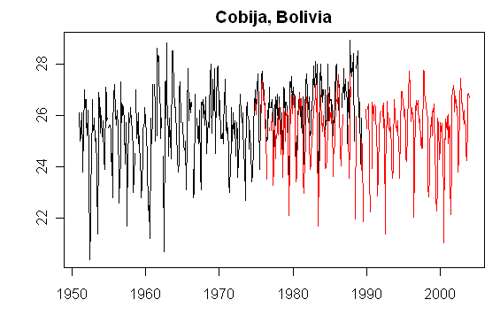
Black – NASA; red – GSN
I did the same thing for Rurrenabaque, another site said by Tamino (relying on NASA) to have no values after 1988. The comparison is shown below.

Black – NASA; red – GSN
During the period of overlap between the GISS dset1 record and the GSN record (1973 on), the GISS version increases at about 0.6 deg C per decade relative to monthly averages calculated directly from GSN daily information as shown below.
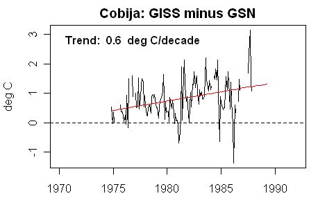
What accounts for the relative increase in the GISS version relative to the GSN version? At present, I don’t know. The primary cause is not at the GISS level, as the GISS version is closely related to the GHCN Raw version. The difference appears to be in how GHCN Monthly handles the original data – a topic that we’ve not even scratched yet.
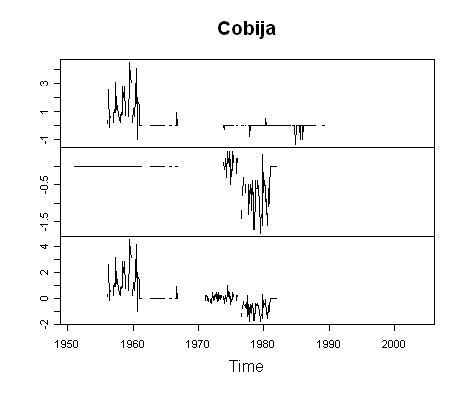
The GISS dset0 file contains three Cobija versions which presumably derive form GHCN somewhere: one goes from 1951-81, one from 1956 to 1989 – both having very long gaps in the 1960s and 1970s and a third version from 1956 to 1989. In some portions, the versions are virtually identical; in other portions, major discrepancies arise. The differences between the three versions is shown below:
So we’ve solved one mystery and encountered others. We’ve established that Cobija (and Rurrenabaque) both have data after 1988. Indeed, the data is collected and stored at the GHCN Daily site. Unfortunately, in this case, the left literally doesn’t seem to know what the right hand is doing as the GHCN Monthly site has failed to link to the updates occurring at the GHCN Daily site.
Tamino says that climate scientists are aware of these problems and “working hard” to resolve them.


121 Comments
off topic, but do you know that The Times (london – u.k.) has nominated you as one of the 50 great world wide eco-blogs???
congratulations!!!
I wonder how many other records have not been updated. We are not playing with a full deck.
Information and google map of station 85041 in Cobija – shows weather data current as of yesterday:
METAR/Synop Information for SLCO (85041) in Cobija, Bolivia
http://weather.gladstonefamily.net/site/SLCO
and they’d have gotten away with it too, if it weren’t for those meddling climate auditors!
all snark aside, it is a little perturbing that Tamino just dismissed the concerns and said the data didn’t exist, when he himself could have googled the same information and done the same work.
All it would do is make the available data better!
A paper by Roel J. W. Brienen Æ Pieter A. Zuidema –
Relating tree growth to rainfall in Bolivian rain forests:
“a test for six species using tree ring analysis for Bertholletia, Cedrelinga and Peltogyne we used the available precipitation data from Riberalta that span the period from 1941 to 2001. For Tachigali the same precipitation data were used, but the chronology only covered the period from 1975 to 2001, because rings near the centre of the discs were not clearly distinguishable. For Cedrela and Amburana we used the rainfall data from Cobija over the period from 1951 to 1981.”
Don’t have any idea why they stopped using Cobija data after 1981.
Paper here:
http://www.springerlink.com/content/hgmh75w31568q458/
Hmm. The record is truncated shortly after the warming trend ends in the raw data.
What a scandalous mess. In these days of automated rss data feeds, and nasa giss can’t keep the record up to date? I think part of the problem is they suffer from the “not invented here” syndrome.
Well now we see why there is no post 1988 data, the hockey stick turned into a boomerang. Can’t have that.
Steve: No, it just looks like failure to collect the data. There are other countries and data sets that end around hte same time.
Here is an interesting record from 1928. Go to page 18 to see the Cobija temp record:
http://docs.lib.noaa.gov/rescue/mwr/Suppl/no31-1928.pdf
I have noticed a pattern of behavior. When StMac gets on the
trail of something interesting…. The proxy warriers are called in. Web site changes happen,
ftp sites change, new faces appear here. It’s rather funny. Nothing can be concluded from this.
20 years of working hard?
Tamino would have more time to actually do work if he weren’t so busy censoring dissent at his arm waving star chamber.
Just curious, but Tamino’s chart showing the trend lines and explanation of how non-rural sites need to be adjusted to local rural sites was interesting. So the southern hemisphere has negative UHI indexes and clockwise rotation toilets. That could make a good youtube video tutorial.
Tamino is continuing to deny that there is any data for these sites after 1988. In an inline comment at about 3:50 pm Eastern (R Clark // February 27, 2008 at 8:50 pm – blig time )
Memo to: Tamino. Just because GISS doesn’t have the data doesn’t mean that there’s no data. It only means that, after 20 years of “working hard”, GISS hasn’t collected the data. See http://www.tutiempo.net/en/Climate/Cobija/850410.htm for a convenient source. The data itself appears to originate at the GSN network which is available from NOAA as described in my post above.
Shat’s the over/under on how long it will take for Tamino to admit that there is data for these sites after 1988?
RE 14. It’s interesting to watch certain folks wade into the Quicksand of GISS data sources.
A simple diagram supplied by ruedy or seto or hansen would end half of these debates.
hmmm.
Since 2008 will be a record cold year, they should really get these other issues off the table.
i am confused. so if someone cliamed that there was no GISS temperature data in the tiny village i live in, he would be wrong because i am recording the data in my own private notebook/blog?
do you think that GISS should adjust data by using non-GISS datasets?
how are you going to splice those different sets together?
Sod:
We know.
Almost like this?:
Down, but not Out!
A week ago we experienced a terrorist-like Denial of Service Attack on our website that rendered it inaccessible to patrons. Unfortunately, the company that managed our website was unable to stop the attack, and we had to make the decision to host our website elsewhere. Moving our website to another server is not a simple task and must take place in stages. For now, only the current weekly issue of CO2 Science will be accessible, followed by a gradual return to full website access and functionality in the coming days and weeks.
For those of you awaiting the release of our DVD Carbon Dioxide and the Climate Crisis, which was advertised on our website shortly before the attack began, that wait will continue for an undetermined amount of time. We apologize for the inconveniences caused by the website attack and our subsequent server move. We hope you will continue to support our efforts and visit us often.
sod sez
That’s what NASA does, sod. From the GISS website:
The Cobija data that Steve located is GHCN data. The station identifier (850410) is the same one that GISS uses:
I’m confused. I thought that GISS was only a data analysis centre, they collected not raw data themselves, only data vouched for by either the gov’t or by peer reviewed scientific publications. Do they really know which end of a max-min thermometer should be up?
Except when it’s not (for 20 years).
#16 sod
Hansen has a method for splicing multiple records for the same location together. It is referred to as the “bias method” (his words) and the algorithm is described here.
Are they working hard or hardly working?Looks like hardly working to me! 😉
@Sod
The data Steve found isn’t just some sod collecting data in his personal notebook. It’s official data from an official station made available through official channels. It’s a site GISS was clearly aware of– since they adjusted the data.
GISS somehow lost track of the continuuing existence of this data.
the graphs don t give the same data for the period of overlap. is this caused by different ways of handling missing data?
thanks for the link. interesting topic!
re 18. Nothing can be concluded. There were other odd occurances. Other things I noticed.
Odd little things. I choose to not mention them. It’s really all rather silly. If Gisstemp were fully documented, then we would be arguing about 5% of the matter. It would be an academic debate: full of rancor without much import. As it stands we may have a different debate: Full of rancor with Giss reputations at stake. Or not.
#24 lucia:
A small clarification — it looks like GHCN lost track of the data between its daily and monthly data sets. Does anyone know of a _valid_ reason why it would be included in the daily but not the monthly?
tamino’s latest is to claim that GHCN is not the source of the data. I posted the following, but I don’t expect him to publish it:
Next will probably be a claim that somehow since the data is on a NOAA site, that it’s not really “from” GHCN, but with tamino, who knows?
w.
The temperature trend looks rather constant. Would that have to be adjusted upward for the recent years to be acceptable?
Steve, why don’t you just make your own study? Go and collect the data and devise your own system to measure global temp. It’s actually the only genuine way to show GISStemp is wrong, everything else is spin.
Mosh, with your track record on guessing identities, I wouldn’t trust your intuition on this. 🙂
CaptDallas,
And the advertisement for “An Inconvemient Truth” showed a clockwise rotation huricane. Maybe that just goes with the subject matter.
Well, I’ve been out playing squash and come back and checked in to see whether Tamino has conceded the obvious point that there is data for Cobija after 1988. He continues to deny the obvious. It’s fun to watch,, At some point, you’d think that the Team would learn to concede unwinnable points. Here’s a sample:
🙂
It’s [doing one’s own study] actually the only genuine way to show GISStemp is wrong,
Wrong, Nathan #30: GISStemp has to stand up to the peer review which indicates that GISStemp is not derived scientifically. Otherwise, there is nothing to disprove to begin with.
What area of science are you in, Nathan?
Mordecai Richler fan, eh?
RE: Cobija Graph with Trend Line
I look at the graph and see a decreasing temp from 1977-1982, then an increase from 1982-1984. At 1985 the temperature drops and starts to rise again. The graph looks somewhat likes a saw-tooth plot. Why does everbody always want to plot a trend line? Maybe that is the way temperature cycles at this site.
Here is an example of step change at the Quatsino BC weather station. The data are summary of multidecadal analysis of min temp for the Fall Equinox Interval (FEI, Sept 16-26) and are reported as min temp +/- AD (where AD is the classical average deviation):
1900-1929 280.5 +/- 1.5 K
1930-1989 281.8 +/- 1.5 K
1990-2005 283.1 +/- 1.5 K
The temperature jump of 1.3 K between the intervals is for real. I compared the yearly means for each decade on either side of the jump point by the t-test and the means are significantly different ( i.e., p is less than 0.05). Note the long intervals of constant temperature. The first two are longer than the PDO cycle. Note the constant AD. The average value for the decades from 1900 thru 2000 is 1.5 +/-0.1 K. For the whole century the change is a whopping 2.6 K, but this was found only for the FEI.
I have to do multi-decadal analysis for the Max Temp for the FEI. If these calculation confirm the temperature jump, then maybe I have discovered some undetected ocean cycle.
When I finish these calculations, I shall report the result here. So stay tuned.
RE33
Why yes, yes I do.
Rurrenabaque Airport:
Map
Terminal
Tower (METAR reports sent here)
Shelter and snack bar
airstrip
Passed an hour reading Tamino who features this figure
This is a critical example of the logic of adjustments. It does not matter if it’s in Peru. Tamino says it is data and can’t be killed, so the negative slope has to be corrected to a positive slope because that’s what the comparison towns do. The obvious question is, why not the reverse procedure?
Scientifically, unless you know the cause, you should not fiddle.
Then when later data came from CA, the correction did not extend past the hinge point at the end of the (then) availavailable data in 1988. Next, Tamino lectures us on how unscientific CA is.
Strange, but not funny.
What is funny is the marketing opportunity for we who live in the Southern hemisphere. See george @ 32 and the quote from CaptDallas2
In the Southern hemisphere I have never seen a rotation toilet. Can I have a plan of one please? Has it anything to do with the non-mathematical expression “… hitting the fan”?
Steve, why don’t you stop complaining and do the research yourself. If it’s so bad that it needs to be done, just do it/
This constant whining is no more than spin. Why don’t you do something constructive and create an alternative toi GISStemp.
Tamino seems to have lost his marbles. He’s comparing Hansen to Charles Darwin, and casts himself as T. H. Huxley. Accordingly he’s changed his pseudonym to “Hansen’s bulldog.”
“Woof!” indeed.
#38
OT big time, but…
Rotation referring to direction of water swirl. Urban myth in the US is that
NH toilets swirl water one way and Aussie toilets swirl the other direction
because, duh, they’re in a different hemisphere. Obviously water swirl is
done via the angle the water is injected into the bowl. Funny myth though.
I hope solving this mystery will allow you to sleep.
Dear Steve, just a little bit of fun, “Cobija” in spanish means “blanket”. Maybe they thought a place called “blanket” is getting warmer anyway and there’s no need for data after 1988 🙂
best
#39 nathan
GISS are paid by the US taxpayer to look after this data. Steve M is a Canadian and so is not. I’m sure Steve wouldn’t mind being funded by the US taxpayer to do this job as it appears that he’s now doing it for free anyway. I wouldn’t mind doing the same for HADCRUT but I’m blowed if I’m going to do it for free when I’m also paying for Phil Jones to do it.
What is most significant here is that it is the very same people who are negelecting to update this data when it shows clear signs that the claimed warming trend doesn’t exist or has reversed who are developing the GCMs that rely on completly non-verifiable water vapour postive feedback effects to claim that we are approaching a ‘tipping point’ in climate change due to man’s use of fossil fuels.
I’d agree with your point that we need someone independent to manage this data and to derive the global temperature anomaly (for what its worth) but I’m buggered as a UK taxpayer if I’m going to have to pay for this job to be done twice. I’m sure most US taxayers feel the same.
KevinUK
Why don’t you do something constructive and create an alternative toi GISStemp.
Nathan, could it perhaps also be that the GISStemp methods are very interesting phenomena in themselves, and are possibly also being revealed here in certain respects as examples of how not to do climate science, thus advancing the science?
John V and others,
data recorded in the daily data set come from the three-hourly synop messages and from the METAR reports. The Tmax and Tmin are, therefore, the maximum and minimum value of all those readings (included the daytime Tmax (for Europe 06-18 UTC) and nightime (18-06) Tmin).
In the monthly data set, for climatological purpouse, you find the actual extremes in a 24 hours period, coming from a daily climatological report which you can find quickly for GCOS stations.
Number of GCOS stations is very limited: for istance in Italy there are one hundred stations with daily values, but only 4 of them belong to the GCOS network.
In the GHCN and GISS data sets almost all italian stations are not updated but data, definitely, exist. And in real time!
For istance, here you can find at 08:00 UTC the climate daily report from Milan of the previous day and, changing the ICAO, also for the others 100 stations. And all this daily, from your home PC!
MJW, being firm, patient, and silent, well, sort of, sure beats barking up the wrong tree.
=====================================
Re my # 29 Geoff Sherrington
The image graph is central to the argument but I’m having trouble getting images up. They show on preview then vanish.
URL is http://s260.photobucket.com/albums/ii14/sherro_2008/2008P4/?action=view¤t=Cobija.jpg
Attempt image from FAQ guidance – can anyone post simple image posting procedures?
The above is from tamino, who says all data should be saved not killed; but because one station has a negative trend it should be adjusted by those positive trends around it. Why not take a simple average? Why not presume that the two stations with positive trends are wrong?
He goes on to say that a hinge pont was chosen near the end of the data and adjustments were made up to there. But now that CA has shown later data, why should the hinge point remain where it is, or at all? The whole exercise is flawed logic in a nutshell.
sod,
He didn’t claim there was no GISS data, he claimed there was no data, period.
Do you understand the difference?
Since when is it the responsibility of the auditor to fix the books?
Casual inspection of the data Steve plotted raised the question of frequency content. There’s an interesting frequency plot in a climate presentation here:
http://www.homepage.montana.edu/~ueswl/Global%20Change%20archival.ppt
Mark W #53 – “bathtubs and drains”
See Wikipedia – Coriolis Effect
I swear I’ve never seen anything like this.
The way data is collected, recorded, and adjusted is the most convoluted mess I’ve ever seen. They acutally use 20 yr old data to adjust current data. They stop collecting data in 1988 then try to tell us what the temp will be in 2050. [snip]
I’ve been in manufacturing for 35 yrs. There would be alot of climate scientists looking for work tomorrow if they were held to private industry standards.
There’s a difference between an audit or checking and doing a complete study. Checking to see if Hansen observe his own definition of “rural” by checking a few stations is something that would have been done had these been financial statements being sent out to the public, prior to them being sent out. We know that this wasn’t done by the peer reviewers of Hansen’s original article.
NASA says that it has a peer review system for data being disseminate by NASA, but this seems to have eluded the NASA peer reviewers.
I’m simply making an observation here that should ideally have been made by one of the peer reviewers or by professionals in the field.
It might be worth submitting a letter to NASA or a comment to the journal, but I’m hardly in a position to re-do the analysis from first principles as a one-man unfunded job, nor is it a job that I would wish to do or manage at this stage of my life.
I do not exclude the possibility that properly chosen stations according to the most meticulous criteria may show results that are quite similar to ones from the present dog’s breakfast.
#39 Yeah, and when you’re done that, go core some trees.
#47 Sherington, wasn’t Tamino’s point that they were indeed just following the published (?) algorithm for adjusting the non-rural stations with neighboring rural records? Weather or not it makes sense for this particular location (which does look suspect). Nobody has advocated a site-by-site approach to adjustments for ROW, have they?
BTW, this was my first visit to Tamino’s website…not impressive at all.
I posted a couple of comments on Tamino’s blog. Only one of them made it through moderation. Here is the first comment that was censored.
I lurked over last night for the first time to “Open Mind” (!!!???)and spent a half hour reading Tamino’s
posts about you and CA. Man! Some of the stuff he says about you is vicious and, as a lawyer, I can tell
you, is actionable. You have scared the crap out of these people.
Would it be possible to find a rural station with a cooling trend which has 2 nearby rural stations showing a warming trend? If it is found, then we can say that assuming that Puerto Maldon shows a cooling trend because of UIH is wrong, and if it is wrong, it shouldn’t be corrected. The same applies to any other stations.
Notice that there is no need that all of the rural stations surrounding the first one show a warming trend. It is enough if 2 of them show the warming trend, as we can’t know which trend would be shown by additional stations in the region of Puerto Maldon if they had existed.
This, of course, doesn’t prove any intention to bias the results in Puerto Maldon by Hansen or anyone. It is clear that they were just following the same procedure they use for the rest of the world. But what this would prove is that it is the wrong procedure, and that you cannot blame UIH for any difference in warming trends with maybe-not-so-nearby rural stations (mostly if you don’t even have enough confidence to clasify stations as rural or urban!)
Quote from Tamino: “Since you’re clearly among friends in the denialist camp, I have some advice for you. Learn to love your enemies, ’cause you can’t trust your friends”…
Wow… this man is desperate, isn’t he?
re 53:
I agree I’ve done several ISO9100 audits myself, and I consider it being a dentist checking teeth:
“Did you brush properly? Then where does this cavity come from?” Auditing is simply checking (probing, time limits that you can’t do everything) if people adhere to standards they agreed to themselves. The auditor just reports if they don’t.
http://en.wikipedia.org/wiki/ISO_9000
ISO 9001
RE37, no one spotted where the thermometer seems to be yet?
#62
What’s that concrete stele at the snack bar?
#62. OK, I’ll bite. Where?
BTW it doesn’t look like there’s been much change in the airport itself since it was built. I wonder when it was constructed.
Hi,
Steve some of the commenter’s on Tamino had a good point. Are there some stations out there with the opposite problem than the stations featured here. Please don’t equate me with Tamino but I do find some of their( I say their because of his multiple pseudo names)post interesting, but I get regularly deleted..LOL.
Re #64
Here’s a couple of videos of Rurrenabaque airport and its surroundings.
Airport
Take-off
The airstrip probably originated as a private strip for the Suarez enterprises in the 30s, after that the buildings were probably due to the military.
Re 62, 64
I had about a dozen more photos than what I posted, showing all angles of the building, front and back, plus other long views of the airstrip. I looked for a Stevenson Screen, an ASOS, and a MMTS or Gill shield device. None can be located in the pictures I have.
There is this curious vertical concrete box/pillar to the right of the snack bar. Note it has a sloped roof, of corrugated siding, and some sort of front door.
It appears to be a crude facsimile of a Stevenson Screen, does it not? What else could it be and for what purpose?
Remember, most stations are placed for the convenience of the observer, and/or for aviation purposes. As my survey has shown so far, the stations well away from buildings are the exception.
Nothing surprises me anymore, so a concrete “Stevenson Screen”? Why not? Maybe we should send a letter to the airport manager there to ask for identification to be sure.
Back in the sixties, there was an extended correspondance in the New Scientist concerning Clockwise/Anti-clockwise whirlpool of bath water at the outflow. If I recall correctly it grew quite rancorous.
All nonsense, of course.
A.
RE66. I think I’ve identified the instrument. In the YouTube video labeled “airport” above we see an approaching walk towards the “pillar”. There is a cubicle built in and in a couple of still frames I paused, it appears to be a recording strip chart hygrothermometer. The white roll on the left side is the giveaway.
Or am I just seeing things? Help me out here.
This unit does dual duty, temperature and humidity.
These aren’t used much anymore, but I’m betting that’s what it is in the concrete pillar hole. It doesn’t look like this airport is at the high priority modernization list by the WMO, so it would not surprise me if this is it. NCDC has no equipment info in the MMS database.
You can keep those old strip chart units running a long time. The only consumables are paper and ink. When they can’t order more, I’ve seen people make their own strip paper from graph paper and wind it on the spool.
If this is it, that concrete pillar sure makes a dandy heat sink.
Anthony Watts says:
What effect would that have on the temperature record?
RE70, it would flatten it, less variance.
The concrete looks new (going by colour). Maybe less than 10 years.
RE72, hmmm, jungle rot, termites, old Stevenson Scren may have bit the dust.
hey, I know; “lets build one that won’t fall apart!”
So it’s in concrete. Just have to develop an algorithm that accounts for that . . .
I have a query in with my contact at NCDC, who’s going to contact WMO. Now we wait to find out if they know what the instrument is. Anybody know of an online WMO inventory?
Why does this discovery matter? Alone, it doesn’t. But: it is part of a pattern of vanishing stations which have left some regions with very little coverage, have left others with no rural sites for “adjustment”, and all due to merely failing to keep up with the data.
Re #70
Bear in mind that it’s not there to give an accurate record, it’s there so that the pilot knows the air density so that he can calculate whether he has enough runway to take off from! As a pilot air temperature, pressure, humidity, wind speed and direction are all I need, +/-1ºC isn’t going to worry me (I wouldn’t be that close to the margin anyway). With that airstrip a major consideration is if it’s been turned to a swamp by rain!
Check out below, see that damn great hill S of the airstrip?
approach plate
Well, if the US doesn’t matter because it’s
Re #77
Phil.
That point is lost on no one. The question that we all keep coming back to is what about this station merits its inclusion in a global climate-monitoring network?
#79 Earle Williams:
Technically, the station is now *excluded* from the network.
The big question in my mind regarding this station, is why it is now excluded from the monthly GHCN dataset. What happened in 1989 to cause its exclusion? I’m hoping to look at the GHCN metadata for clues but have been very busy.
#80. The reason – as I’ve said MANY MANY times, is that GHCN has failed to update many stations for about 20 years – Dawson ends in 1990, Barbinsk, Russia ends in 1990, Cobija in 1989 – and their important customers – NASA, CRU,… have iether not noticed or not cared. It’s not an effect peculiar to Cobija; it’s a systemic problem.
Hi,
Found this about Rurrenabaque Airport so far
http://weather.gladstonefamily.net/site/SLRQ?tile=10;showall=1
http://www.tutiempo.net/en/Climate/Rurrenabaque/08-1993/851410.htm
Re #80
John V.,
Well, if we’re going to get technical/pedantic, the station is hardly excluded from the global network of GISTEMP. If that were the case there would be no reference to it in GISTEMP. Whether or not current data are excluded, the station remains in the network. I agree with Phil.’s point about it being good enough for the local aviators. My rhetorical question, and one that should be answerable by a robust global network, is what makes it good enough to be used to monitor global climate? I’m not saying it is or isn’t, but simply because it works for the local pilots does not necessarily mean it works for the rest of the world.
#81 Steve McIntyre:
Yes, I realize the problem is with GHCN not updating the stations.
My question is *why* has GHCN not updated *these* stations.
Is there a pattern?
Is it random?
I’m not asking you to look into it.
I’m only saying that, to me, these are the key questions.
(If the answer is already known I haven’t found it with a search of this site — but my success rate with CA searches is not very good).
It looks to me like they use Stevenson Screens in Bolivia:
http://www.senamhi.gov.bo/meteorologia/
And it might be in the background around 1:15 in the video.
Rurrenabaque airport: Photo
Some commenters at all blogs, always make some good points. And yes, it may be there are stations with the opposite problem. If there are many with the opposite problem, then NASA GISS’s correction scheme may be simply adding noise, without adding bias.
Of course, adding noise to the signal is not a good thing either. Noise degrades data; it doesn’t improve it.
Whether NASA’s efforts improve or degrade the data, what’s being done with historic data is interesting. Seeing the photos of stations, the individual temperature traces and the magnitude of the corrections, gives us all some insight into the possible level of precision or accuracy of the GISS data product.
So, even though Tamino’s commenters may be correct when they suggest Hansen’s mistakes may not introduce a bias,that would still leave the question of introducing noise. And if it’s red noise, pink noise or blue noise, this would have serious consequences for empirical evaluations of climate models or other theories. (And of course, there is still the possibility that bias is introduced.)
RE85, pk good catch on the Rurrenabaque video
You may very well be right. see below. Fenced in area surrounds the white “whatever” and it appears to be above ground, so looks like metal stand. Other objects in the fenced in area could be rain gauge and evapotranspiration pan. The fenced in area fits the general theme of weather stations I’ve seen around the world.
Here is a photo of one their automated weather stations, showing a fence.
It is hard to say without adequate records.
Everyone forgets that GISS take data from Many sources. Including our very own hans.
“For Hohenpeissenberg – http://members.lycos.nl/ErrenWijlens/co2/t_hohenpeissenberg_200306.txt
complete record for this rural station
(thanks to Hans Erren who reported it to GISS on July 16, 2003)”
Hans, perhaps you can report this missing data to them.
I’m working on a post reviewing some of this. Hansen et al 1999 illustrated their adjustment using two sites where there were substantial positive UHI adjustments – Phoenix and Tokyo. They noted the existence of negative adjustments, but did not discuss any examples.
I notice that I’m being criticized at Tamino for picking some “bad” examples – well, Hansen already cited the “good” examples in the publication. One way of sorting through very large data sets is to look at extreme cases at both ends as it illuminates the process.
I’m being criticized for not assessing whether Hansen’s failure to observe his reported protocol “matters”. Well, up to a couple of days ago, I didn’t know that Hansen had used flawed meta-data in his classification of sites as “rural”. Tamino says that these flaws have been known at NASA for some time and that may be the case. But I was a bit surprised at just how flawed the meta-data was in a spot check.
Exacerbating the problem is the failure to update many of the rural series in the GISS/GHCN data set since about 1989-1990.
I’m doing some work trying to assess the impact – the issue has only been in play a couple of days. My hunch – and it’s no more than a hunch right now – is that the problem is not that the adjustment introduce an upward bias, but whether they are successful as an “urban” adjustments. If they fail as an adjustment for UHI, as seems increasingly likely, then what we are left with is a reference network of what increasingly appears to be “small town/city” sites. If that’s the case, then the claims to have allowed for UHI in the original article would be overstated.
AS I’ve discussed on many occasions, I think that it would be very desirable to identify the very BEST stations, wherever they occur in the world – BEST not just fight now, but with good metadata back through the 1930s at least, and build from there. I don’t exclude the possibility that the answer might be similar to received versions. But I do wonder whether some of the difference between the US and ROW histories relates to the different handling and metadata, as opposed to regionalized climate, and I would have thought that users of the data would welcome the fact that some scrutiny was being put on the dataset.
I was amused by this post at Tamino: “It is of course sobering to realize that some stations contain error patterns on the 3 degree level”
Obviously not.
Me, too. Condsidering the differences between the time/temperature curves for the USA and the ROW, the USA doesn’t seem to be teleconnected very well with the rest of the world.
I am sorry for sending a comment in that needed deleting. I am just anal about using good data since verifying data is how i made my money for the last few years. Sorry for making extra work for you steve to delete my comment. Keep up the good analysis.
The reason is clear, hasn’t Rev.Gore told us “The discussion is over”?
RE 90.
Another thing to consider steve. If a site is Rural in 1980 ( less than 10K people) it is designated
RURAL post 1980.
A city Designated Urban, 100000 is Urban for all time.
So, a city that moves from a 1980 population of 9000, to a 2008 population of 20,000.
Will adjust a city of 100000 in 1980.
If, as Oke argued in 1973, the UHI effect is .73C*log10(pop). then a rural site moving from
5K people to 15K people will show a strong strend than a big city that moved from 100K to 110K
people. This would have the effect of a rural site having a warmer TREND than an urban site.
Especially if the reposnse to population is .73CLog10(pop)
Hi,
Steve wasn’t trying to be critical just thought is was a good point and have not seen stations that are opposite. Do you think that the bias shown in GISS will tend to bias warmer when the trend is warming and cooler if the trend is cooling. What I mean is that it will bias more either way depending on the trend. Like recently when GISS shows a greater Delta T for January 2008. I think that all of the adjusting may put a lot of noise into the system because they adjust up, down or not at all and if you have error they can propagate to falsify the data. I hope that makes sense.
LOL I’ve known for a while that Tamino is Hansen’s lap dog. Good thing he admits it now.
And he also plays with sock puppets… how delightful.
Steve-
Have you considered keeping an open letter to the data agency with the known issues in it? I’m not talking about the techinical stuff like record splicing, but the true data inconsistencies, such as data that is available daily, but not monthly, sites with the wrong classification, etc. Then leave it open on the site and send the link to GISS or whomever. I think that would be a nice way to make an impact. The data folks can see all of the problems identified in one place instead of all over these different threads.
Bill
re 89:
Hanssen was only eager to include Hohenpeissenberg because it shows a temperature hockeystick, and only if you truncate at 1880.
Not just wrong, snotty about it. “Does Anthony Watts have photographs?” asks Tamino. Duh.
Perhaps one day we’ll all realize that arguing with or explaining things to um, the less swift, is probably almost always a waste of time, even if they’re really trying to learn something and not just stir things up….
Sam, remember the old saying:
Don’t wrestle with the pigs. You get dirty and the pigs enjoy it!
Now over 200 comments on Tamino’s post, and no confession to his two (at least) proven misstatements of fact.
If science is self-correcting, I think we can X him off any list of ‘science.’
That’s tamino.wordpress.com, Robert.
RE101, Tamino is a very smart person, and has excellent math skills, much like our host, Mr. McIntyre. The difference however is in the social skills. Mr. McIntyre will gracefully concede error or mistakes but Mr. “Tamino” seems incapable of doing so and is hostile to anyone not in sync with his world view. I’ve also been at the end of that hostility several times.
One removes sophomoric comments from the blog, while the other leaves them and add some of his own.
Perhaps Tamino should join a squash or racquetball league.
My solution is to simply not visit anymore. As I see it: Vitriol=Irrelevancy.
Dr. Joanne Simpson has it right, in case you haven’t seen her extraordinary essay I have it here.
Olive branches are needed to move the science forward, that is, assuming the science is not settled.
I had a thought today, and that was that the issue of climate change has become tribal, and that entrenched factions operate much like warring tribes, hurling spears made of data, graphs, and algorithms.
Except for me of course, I hurl pictures. 😉
“Some commenters at all blogs, always make some good points. And yes, it may be there are stations with the opposite problem. If there are many with the opposite problem, then NASA GISS’s correction scheme may be simply adding noise, without adding bias.”
I was looking at some of the Argentina stations, and I did see a couple of non rural stations where the temperature trend was actually decreased. But nothing like the magnitude of the trend increases that Steve saw in his stations.
Re #102
Robert Wood,
I’m pretty sure that domain isn’t associated with the individual posting as Tamino at http://tamino.worpdress.com
I understand Steve McIntyre’s desire to send a little jab Tamino’s way now and then, but frankly this person gets much more attention here than he deserves. The reason he uses a pseudonym is pretty clear – he wants free license to vent his spleen toward anyone that disagrees with his Open Mind. My only wonder is why he picked the Tamino nym. Was BileFont taken?
The link did not post properly
http://www.db.ripe.net/whois?form_type=simple&full_query_string=&searchtext=193.26.193.29&do_search=Search
RE109 and other similar comments.
Don’t waste time on this, we already know who he is, it was posted months ago on CA, and, why bother? What good is it once you know? Unless he says something actionable and damaging, the need isn’t there. But maybe it is according to comment 57.
One of the things I learned in the TV news business was that controversy generates interest. Tamino is doing just that. He’s hoping the vitriol will generate controversy and bring in visitors to absorb the information. But he’s missed a key ingredient, and I’ll leave that for him to discover on his own.
IMHO, the best defense is simply to ignore him until he learns how to be a gentleman. We all have that power to exercise.
So back to the real question, why isn’t the data updated to the most current available, and why has this gone on for almost 20 years? Are there no satisfactory answers, just our wild speculation?
RE 113. Initially I thought it might be one of Hansen’s Undocumented Station exclsuions.
This snipping of records is largely undocumented. The stations with records “clipped” are as follows
122637720000 LAMU lat,lon -2.3 40.8 omit: 1914/07
148628400000 MALAKAL lat,lon 9.6 31.7 omit: 1990/08
148628400000 MALAKAL lat,lon 9.6 31.7 omit: 1991/03
303838210000 IGUAPE lat,lon -24.7 -47.5 omit: 1985/04
403718670006 THE PAS,MAN. lat,lon 54.0 -101.1 omit: 1995/05
425722190010 COVINGTON lat,lon 33.6 -83.9 omit: 1882/11
425722250030 TALBOTTON lat,lon 32.7 -84.5 omit: 1988/06
425722250030 TALBOTTON lat,lon 32.7 -84.5 omit: 1988/07
425722780090 WICKENBURG lat,lon 34.0 -112.7 omit: 1908/11
425723760020 PRESCOTT lat,lon 34.6 -112.4 omit: 1904/08
425724220030 FRANKFORT LOCK 4 lat,lon 38.2 -84.9 omit: 1881/09
425724690010 DILLON 1E lat,lon 39.6 -106.0 omit: 1910/07
425724710050 LOA lat,lon 38.4 -111.6 omit: 1903/07
425725190010 AUBURN lat,lon 42.9 -76.5 omit: 1849/07
425725490030 ALGONA 3W lat,lon 43.1 -94.3 omit: 1863/06
425727560040 PEMBINA lat,lon 49.0 -97.2 omit: 1887/07
425745300040 LAMAR lat,lon 38.1 -102.6 omit: 1895/12
425746470060 JEFFERSON lat,lon 36.7 -97.8 omit: 1899/07
501947190020 GILGANDRA POST OFFICE lat,lon -31.7 148.7 omit: 1920/07
651032920010 SCARBOROUGH UK lat,lon 54.2 -.4 omit: 1912/08
651032920010 SCARBOROUGH UK lat,lon 54.2 -.4 omit: 1912/09
623160900003 VERONA/VILLAF lat,lon 45.4 10.9 omit: 1987/04
623161580004 PISA/S.GIUST lat,lon 43.7 161.5 omit: 1987/10
113655550000 BOUAKE lat,lon 7.7 -5.1 omit: 0-1954
115624500010 SUEZ lat,lon 29.9 32.6 omit: 0-1888
140632500000 BARDERA lat,lon 2.4 42.3 omit: 0-1919
150617010000 BATHURST/YUNDUM lat,lon 13.4 -16.7 omit: 0-1939
155674750003 KASAMA lat,lon -10.2 31.1 omit: 0-1932
205526520000 ZHANGYE lat,lon 38.9 100.4 omit: 0-1944
205528360002 DULAN lat,lon 36.3 98.1 omit: 0-1949
205535640010 XINGXIAN lat,lon 38.5 111.1 omit: 0-1929
205538630000 JIEXIU lat,lon 37.1 111.9 omit: 0-1950
205560800020 LINXIA lat,lon 35.6 103.2 omit: 0-1951
205565710002 XICHANG lat,lon 27.9 102.3 omit: 0-1938
205565860010 LEIBO lat,lon 28.3 103.6 omit: 0-1954
205573480000 FENGJIE lat,lon 31.1 109.5 omit: 0-1956
205577990000 JI’AN lat,lon 27.1 115.0 omit: 0-1934
207428070003 CALCUTTA/ALIP lat,lon 22.5 88.3 omit: 0-1859
207432790003 MADRAS/MINAMB lat,lon 13.0 80.2 omit: 0-1859
224434660003 COLOMBO lat,lon 6.9 79.9 omit: 0-1869
302853650000 YACUIBA lat,lon -21.9 -63.6 omit: 0-1935
315814050000 CAYENNE/ROCHA lat,lon 4.8 -52.4 omit: 0-1911
403717140040 SHAWINIGAN,QU lat,lon 46.6 -72.7 omit: 0-1918
414765560010 MASCOTA, JALISCO lat,lon 20.5 -104.8 omit: 0-1940
414767260010 CUAUTLA, MORELOS lat,lon 18.8 -98.9 omit: 0-1953
425702710000 GULKANA/INTL. lat,lon 62.2 -145.4 omit: 0-1930
425722130010 WAYCROSS 4NE lat,lon 31.3 -82.3 omit: 0-1884
425722330030 AMITE lat,lon 30.7 -90.5 omit: 0-1885
425722530000 SAN ANTONIO/I lat,lon 29.5 -98.5 omit: 0-1868
425722530010 ENCINAL lat,lon 28.0 -99.4 omit: 0-1913
425722570050 TEMPLE lat,lon 31.1 -97.3 omit: 0-1885
425722710030 LUNA RS lat,lon 33.8 -108.9 omit: 0-1902
425722740020 TUCSON U OF AZ lat,lon 32.2 -110.9 omit: 0-1889
425722970060 TUSTIN IRVINE RANCH lat,lon 33.7 -117.8 omit: 0-1909
425723120000 GREENVILLE/GR lat,lon 34.9 -82.2 omit: 0-1907
425723270050 BOWLING GREEN FAA AP lat,lon 37.0 -86.4 omit: 0-1884
425723400040 BRINKLEY lat,lon 34.9 -91.2 omit: 0-1889
425723600020 SPRINGER lat,lon 36.4 -104.6 omit: 0-1899
425723650020 LOS LUNAS 3SSW lat,lon 34.8 -106.7 omit: 0-1894
425723710020 KANAB lat,lon 37.1 -112.5 omit: 0-1909
425723710030 ZION NATIONAL PARK lat,lon 37.2 -113.0 omit: 0-1917
425723760020 PRESCOTT lat,lon 34.6 -112.4 omit: 0-1879
425724170010 DALE ENTERPRISE lat,lon 38.5 -78.9 omit: 0-1891
425724280060 KENTON lat,lon 40.7 -83.6 omit: 0-1879
425724620040 CHAMA lat,lon 36.9 -106.6 omit: 0-1900
425724710040 BEAVER lat,lon 38.3 -112.6 omit: 0-1912
425724830010 DAVIS EXP FARM 2WSW lat,lon 38.5 -121.8 omit: 0-1909
425724880000 RENO/INT., NV lat,lon 39.5 -119.8 omit: 0-1889
425724920010 LODI lat,lon 38.1 -121.3 omit: 0-1890
425725070070 TAUNTON lat,lon 41.9 -71.1 omit: 0-1883
425725250010 NEW CASTLE 1N lat,lon 41.0 -80.4 omit: 0-1900
425725250050 FRANKLIN lat,lon 41.4 -79.8 omit: 0-1894
425725510070 DAVID CITY lat,lon 41.3 -97.1 omit: 0-1894
425725540030 WEEPING WATER lat,lon 40.9 -96.1 omit: 0-1905
425725830050 GOLCONDA lat,lon 41.0 -117.5 omit: 0-1889
425725910004 RED BLUFF/MUN lat,lon 40.2 -122.2 omit: 0-1889
425725910020 WILLOWS 6W lat,lon 39.5 -122.3 omit: 0-1905
425725940010 FORT BRAGG 5N lat,lon 39.5 -123.8 omit: 0-1934
425725940020 ORLEANS lat,lon 41.3 -123.5 omit: 0-1928
425726080020 WOODLAND lat,lon 45.2 -67.4 omit: 0-1921
425726170040 LAKE PLACID 2S lat,lon 44.3 -74.0 omit: 0-1919
425726510040 ALEXANDRIA lat,lon 43.7 -97.8 omit: 0-1884
425726700090 HEBGEN DAM lat,lon 44.9 -111.3 omit: 0-1912
425742010020 PORT TOWNSEND lat,lon 48.1 -122.7 omit: 0-1874
425742010090 BLAINE lat,lon 49.0 -122.7 omit: 0-1899
425744800060 UTICA lat,lon 43.1 -75.2 omit: 0-1879
425744900070 LAWRENCE lat,lon 42.7 -71.2 omit: 0-1859
425745000030 MARYSVILLE lat,lon 39.2 -121.6 omit: 0-1897
425745010010 ELECTRA PH lat,lon 38.3 -120.7 omit: 0-1910
425745010040 LAKE SPAULDING lat,lon 39.3 -120.6 omit: 0-1926
425745090010 LOS GATOS USA lat,lon 37.2 -122.0 omit: 0-1890
425745090040 LIVERMORE lat,lon 37.7 -121.8 omit: 0-1881
425745160060 HEALDSBURG lat,lon 38.6 -122.9 omit: 0-1899
425745330020 FORT COLLINS lat,lon 40.6 -105.1 omit: 0-1874
425746190010 DEATH VALLEY lat,lon 36.5 -116.9 omit: 0-1921
425746300010 SOCORRO lat,lon 34.1 -106.9 omit: 0-1889
425746350030 CANYON-DE-CHELLY lat,lon 36.2 -109.5 omit: 0-1929
425746620040 FARMINGTON lat,lon 37.8 -90.4 omit: 0-1890
425747350010 SNYDER lat,lon 32.7 -100.9 omit: 0-1899
425747950010 FORT PIERCE lat,lon 27.5 -80.3 omit: 0-1879
432788970000 LE RAIZET,GUA lat,lon 16.3 -61.5 omit: 0-1940
501943330000 BOULIA lat,lon -22.9 139.9 omit: 0-1899
501943660010 BOWEN POST OFFICE lat,lon -20.0 148.3 omit: 0-1909
501945660000 GYMPIE (FORES lat,lon -26.1 152.6 omit: 0-1909
501945890000 YAMBA lat,lon -29.4 153.4 omit: 0-1899
501947840000 TAREE lat,lon -31.9 152.5 omit: 0-1909
501948420000 CAPE OTWAY lat,lon -38.8 143.5 omit: 0-1900
501949330000 GABO ISLAND lat,lon -37.6 149.9 omit: 0-1899
501949370000 MORUYA HEADS lat,lon -35.9 150.2 omit: 0-1898
523969950000 CHRISTMAS ISL lat,lon -10.4 105.7 omit: 0-1970
615075100003 BORDEAUX/MERI lat,lon 44.8 -.7 omit: 0-1879
615076900003 NICE lat,lon 43.7 7.2 omit: 0-1859
623160900003 VERONA/VILLAF lat,lon 45.4 10.9 omit: 0-1879
623161400000 BOLOGNA/BORGO lat,lon 44.5 11.3 omit: 0-1879
636085060002 HORTA (ACORES lat,lon 38.5 -28.6 omit: 0-1916
649170300004 SAMSUN lat,lon 41.3 36.3 omit: 0-1879
651039170003 BELFAST/ALDER lat,lon 54.7 -6.2 omit: 0-1878
205544710010 GAIXIAN XIONGYUE lat,lon 40.2 122.2 omit: 1920-1930
205567780004 KUNMING lat,lon 25.0 102.7 omit: 1940-1945
207425150003 CHERRAPUNJI lat,lon 25.3 91.7 omit: 1991-1993
425723830030 TEJON RANCHO lat,lon 35.0 -118.7 omit: 1909-1912
425726720010 DIVERSION DAM lat,lon 43.2 -108.9 omit: 1988-1989
RE110, Mosh
I have all these stations from the list above surveyed. I have been to many of them myself.
425723760020 PRESCOTT lat,lon 34.6 -112.4 omit: 1904/08
425722780090 WICKENBURG lat,lon 34.0 -112.7 omit: 1908/11
425745300040 LAMAR lat,lon 38.1 -102.6 omit: 1895/12
425722530000 SAN ANTONIO/I lat,lon 29.5 -98.5 omit: 0-1868
425723710030 ZION NATIONAL PARK lat,lon 37.2 -113.0 omit: 0-1917
425742010090 BLAINE lat,lon 49.0 -122.7 omit: 0-1899
425747950010 FORT PIERCE lat,lon 27.5 -80.3 omit: 0-1879
425722130010 WAYCROSS 4NE lat,lon 31.3 -82.3 omit: 0-1884
425722570050 TEMPLE lat,lon 31.1 -97.3 omit: 0-1885
425722740020 TUCSON U OF AZ lat,lon 32.2 -110.9 omit: 0-1889
425722970060 TUSTIN IRVINE RANCH lat,lon 33.7 -117.8 omit: 0-1909
425724830010 DAVIS EXP FARM 2WSW lat,lon 38.5 -121.8 omit: 0-1909
425724880000 RENO/INT., NV lat,lon 39.5 -119.8 omit: 0-1889
425724920010 LODI lat,lon 38.1 -121.3 omit: 0-1890
425725070070 TAUNTON lat,lon 41.9 -71.1 omit: 0-1883
425725250010 NEW CASTLE 1N lat,lon 41.0 -80.4 omit: 0-1900
425725910004 RED BLUFF/MUN lat,lon 40.2 -122.2 omit: 0-1889
425725910020 WILLOWS 6W lat,lon 39.5 -122.3 omit: 0-1905
425725940010 FORT BRAGG 5N lat,lon 39.5 -123.8 omit: 0-1934
425725940020 ORLEANS lat,lon 41.3 -123.5 omit: 0-1928
425726080020 WOODLAND lat,lon 45.2 -67.4 omit: 0-1921
425742010020 PORT TOWNSEND lat,lon 48.1 -122.7 omit: 0-1874
425745000030 MARYSVILLE lat,lon 39.2 -121.6 omit: 0-1897
425745010010 ELECTRA PH lat,lon 38.3 -120.7 omit: 0-1910
425745010040 LAKE SPAULDING lat,lon 39.3 -120.6 omit: 0-1926
425745090040 LIVERMORE lat,lon 37.7 -121.8 omit: 0-1881
425745160060 HEALDSBURG lat,lon 38.6 -122.9 omit: 0-1899
425745330020 FORT COLLINS lat,lon 40.6 -105.1 omit: 0-1874
425746190010 DEATH VALLEY lat,lon 36.5 -116.9 omit: 0-1921
425723830030 TEJON RANCHO lat,lon 35.0 -118.7 omit: 1909-1912
I tried to think what might be common to these. I noted that quite a number of them are right here in my area, and are the test stations for USHCN2
One of them made absolutely no sense as to why it would have a record clipped.
Tejon Rancho, which is one of the oldest and most complete records in California. Same place, unchanged essentially in 100 years. Jim Goodridge, former California State Climatologist cites it as a “benchmark station”.
I also noted that many of these stations have significant microsite bias today. Wickenburg, Tucson, Reno, Lodi, Woodland(Maine, not Calif), Marysville, Lake Spaulding, Livermore, Healdsburg, Death Valley, and Red Bluff
Red Bluff is interesting, not USHCN, but often cited as one the hottest temp of the day in the USA until it converted to ASOS in early 90’s. The screen was right on the tarmac. I found the fellow that runs the air museum there and he pointed to the exact spot.
All these I noted have significant microsite issues in the present, but the records of the far past are the ones snipped.
It almost seems like a case of removing outliers for the time series. I remember something I saw recently about statistics, which I was researching thanks to another thrashing by Tamino. It said: “if you remove the outliers, your correlation will be better”.
There’s something in this, not sure what.
Re # 111 Anthony
Of course, this is the the fundamenal axiom in mineral exploration. We always valued the correlation higher than the new mine, by throwing out the outliers.
As I have posted before, it is the unexpected result which is often rich in new information. Its fate is not to be smoothed to oblivion; its fate is to give birth to advances in understanding.
That’s why I’m completely at home with Steve saying he looks at both ends of the spectrum of variation from normal. That’s where new mechanisms, unforeseen variables and so on are more often found.
(OT. Can someone tell me how to get posted images to stay there? They appear in the preview than vamoose in the upload) Thanks. Geoff.
Toilets flow anticlockwise?
In Australia we can type away while much of the ROW is asleep, so we get time to pester the host with irrelevancies.
The example above has been thoroughly researched for years and the conclusion is that microfeatures can occasionally bias flow in one direction or another in a given apparatus.
While we are about that region of the anatomy, see #20 Joe Black who asks –
A question in return. Up what?
Seriously, I was and am worried about the ongoing use of data adjusted by dubious general methods. I asked our Bureau of Meteorology what happens with data from stations now so urbanised that they surely have UHI. Were these data still used, despite known deficiencies? Answer – we just generate the data. Once it leaves our hands we have no control over the uses to which it is put or by whom. This leads one to imagine that, despite the existence of and publicity given to recent high quality network attempts, a lot of poor information is still used either blindly or knowingly by those who know no better.
This is the classic von Braun rocket excuse: I just send them up, who cares where they come down? That’s not my department, says Wehrner von Braun. (Tom Lehrer song, for the youngsters).
Re#108, I don’t think he’s just out to seek controversy. As someone recently put it, he’s “a nasty piece of work.” He seems to me to be the variety of person who seeks/needs to feel empowered. He has the complete freedom to speak his views (under his fake name, of course) on his site, mislead whenever he feels like it, and censor anyone who points out when he his amiss. There are folks out there who seem to think having a blog is their own fantasyworld to rule, and I put him in that category. Being a frothing AGW believer who uses the most vehement terminology and methods towards anyone who questions him, he gets to paint himself as the hero of Taminoland while conquering the evil McIntyre and denialists in the simulated battles on his blog.
RE112, Geoff.
I went and looked at what code remains after your image insertion attempts, ( only this /img> remains) and what is happening is that WordPress is removing it when published due to specific formatting requirements they have.
I suspect you are manually typing in HTML tags with your posts, am I right?
I stopped doing that long ago since WP eats them if not formatted the way it likes.
1. When you reply to this, look at the comments form. See the “Img” button between “Link” and “Close Tags” on the right?
2. Press it, if you have popup blocker enabled, clear it/enable it for this site, may have to press second time.
3. Then you get a form, paste the image URL in it (the image has to exist on a server somewhere, yours, flicker, NOAA, whatever and be public, bear in mind that some servers allow a browser to access within a web page, but won’t allow direct image link, you may have to test this.) then press OK
4. Then it will ask for description of the image, type in whatever you want, if lazy, just type “pix” but type in SOMETHING, then press OK
5. Finish your comment, press “Submit Comment”, bask in your success.
RE: #114
Excellently stated. I read that thread in its entirety at Tamino’s blog, and had the exact same impression as yours.
the genius of GW theory illustrated (comments at RC)
Re 115 Anthony housekeeping
I don’t have a private web site so I use public image handling companies. The one I tried, Photobucket, uploads my images ok then gives me 4 choices as to use (like simple URL, HTML, Use on Blog, Use on Bulletin Board). I get thru the Img part of WordPress ok, get the right box and paste the Photobucket line into it. But there must be some incompatibility. matbe wordpress needs a title for the image, that sort of thing.
Easy solution – you mention flicker as another supplier of image handling. I’ll give them a try. These’s just one fiddly step that I’m missing and I can’t find what it is from FAQs etc.
Other stuff – I’ve looked at the list of stations from steven mosher # 110. For Australia the changes merely lop off some very early years and I don’t have an argument with this. Mind you, I have not looked in detail at the data to see if it lops off inconvenient trends. Would that be worthwile to investigate?
Many thnaks geoff.
#99 Hans Erren
The Hohenpeissenberg pattern with high temps at the end of 18th century is common for all Central European stations, and regardless of their urban or rural status. The city-center Klementinum is the same and it’s trend isn’t much different from the mountaintop (since 1906) Milesovka. I read that this is ascribed to oscillations between continental and Atlantic weather pattern, but don’t know if this explanation is still valid.
Hansen’s Bulldog?
I modified my blog header and added a a picture of Munchkin, my doggie mascot on Feb 21.
Did I start a “climate blog” trend?
FWIW, Munchkin lives at the DOE ARM SGP site. So, he really is “The Global Climate Change Dog!”
re 120 Blog dogs in knitted togs?
I will never forget the first time you posted on Tammy’s site and showed that boy some
math. HA. makes me laugh to this day.
2 Trackbacks
[…] adjustments outside the U.S. even begin to deal with the problem. Posts were here here here here here […]
[…] of Chile, on another occasion the lost city of Wellington NZ and, most recently, helped NASA find the lost city of Cobija, Bolivia. Today we’ll help the climate science community identify the provenance of […]