Minus Kim Basinger. http://wattsupwiththat.wordpress.com/2008/03/24/how-not-to-measure-temperature-part-54-los-angeles-the-city/
As a reader at Anthony’s blog notes, there’s an interesting history here.
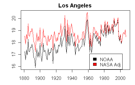
Note that the temperature graphic shown linked at Anthony’s site is the version used by NOAA, rather than the version used by NASA. The differences are shown in the two graphs below. The NASA adjusted version increases past L.A. temperatures by an amount increasing linearly to about 1.2 deg C, while NOAA uses a version without NASA’s urban adjustment.
While NASA’s U.S. temperature history shows warm 1930s, with 1934 vying with 1998 as warmest year of the century, NOAA, under the direction of Tom Karl, makes no corresponding effort to adjust for urbanization.
Anthony, Atmoz and ourselves have recently discussed the ineffectiveness of the NOAA Filnet adjustment to detect station changes (see Lampasas and other sites). Here we have another example of exactly how ineffective this algorithm is. Neither NOAA nor NASA pick up the re-location of the Los Angeles station (which in this case appears to result in a decrease in temperature. Both NOAA and NASA GISS failed to pick up and adjust for the re-location even though two NASA employees published an article on the relocation in an article published on the NASA website here: http://www.jpl.nasa.gov/news/features-print.cfm?feature=1273 stating:
The magnitude of change reflected in our study strongly suggests this relocation will bias long-term climatic studies.
So it’s not just Anthony Watts who’s observed that station re-locations can bias climatic studies. As we’ve observed previously, climate scientists seem much better at detecting discontinuities with downward biases (such as the most recent L.A. move) than ones with upward biases, such as Lampasas or the Y2K error.


66 Comments
Great post.
A determined Sgt. Joe Friday would be just the right guy to investigate these things — “just the fact, ma’am!”
He’d also ask if relo to cooler is a bad alibi, why isn’t relo to warmer?
Imagine … moving a thermometer from the top of a parking garage to a piece of grass can drop the temperature 2C.
Who would have guessed?
Who would have guessed that Hansen’s urbanization adjustment wouldn’t have caught the discontinuity?
Why for some reason do I doubt assurances the biases are taken into account?
I would 😀
Here is GISS LA minus San Francisco:
Bruce (#3) says,
And that’s just a patch of grass, surrounded by avenues, parking ramps, and tennis courts!
IMHO, urban warming is a real problem for the many people who live in urban areas, but one caused by urbanization, not by CO2.
And how about previous moves, or are we to suppose the parking structure has been in the same location since 1880? The GISS correction does not reveal the previous moves either….
I agree with you totally, Hu. Just looking at the UHI satellite images of rain tens of miles away and cities hundreds of thousands of square miles in size, the idea that urbanization (and everything that goes along with it) having little or no effect is silly, especially saying it’s less of an effect than 30% or 150% or whatever more of a trace IR gas over the same time period.
Besides the anomaly trend being questionable in and of itself, as well as any cause effect relationships ascribed to it, and the fact that it doesn’t constantly go up (or that the trend is not even being exceeded by the yearly values). The much simpler explanation is the number of people and everything that goes along with us and our technology. The Earth population chart matches the anomaly well too, anyway, so what’s causing what?
I think anyone that doesn’t at least seriously consider the anomaly trend at the source is doing themselves a diservice. It all boils down to one thing; do we measure it the same way over the period in question? And the answer is no. Types and locations of the devices.
So then you have to look at the raw data if you are looking to coroborate that. And lo and behold, the monthly anomalies all snap higher pretty suddenly in the late 70’s. So then you can logically think; what would cause them to do so? There’s plenty of causes, plenty for each of the possible meanings of the monthly numbers. Too many to deal with. So what’s wrong with having an unknown sitting there on the table that we don’t have a concrete answer for?
Then perhaps we realize it all boils down to human nature. The quest to answer everything. The hatred of things we don’t understand on some primal level, perhaps.
Hans Erren # 6
If you think the weather in San Fransisco and Los Angeles are in any related then maybe you should work for Hansen.
I still can’t get over the fact that Hansen raises older temps to correct for UHI rather than lowering latter temps. Makes no physical sense. Is there some reason related to homogenization or land ocean temps I’m missing?
Barry:
You can’t alter “known” temperatures (current ones, measured with accurate equipment) so you alter “uncertain” old temperatures. At least that way no one can dispute your adjusted temperatures with actual measurements without a time machine.
10 Mike
You haven’t heard of teleconnections? If trees can reflect temperatures thousands of miles away,……
Once again the interesting point should be whether the UHI is making a difference in the trend of the temperature. What would be great would be to go back to the old garage site and reinstall the sensor and then track both sites for several years. Do they show similar trends with the garage site a constant several degrees warmer, or are they diverging with the garage site increasing more rapidly?
13 Pat,
Those are only the trees that have been touched by the wizzard mann. 😉
14 Paul29,
I think the point here is why didn’t Hansen or NOAA catch the discontinuity after the change in 1997. It shows that the NOAA USHCN Version 2 homogenization algorithm did not do it’s job, particularly since none of the surrounding stations show a temperature pattern similar to Los Angeles.
Anyone who has lived in the LA basin and traveled around in the area knows that you can move as little as a few of miles and have a huge difference in climate. One morning living in Topanga Canyon it was 28 degrees when I left my house and 14 minutes later in the San Fernando Valley the temp was 52. Where I lived was right at the edge of the marine layer and temperatures can vary wildly on a daily basis whether or not the marine layer is in place.
This happens all around LA.
If the problem is relocation of sites and other time discrete events, I see an easy way to get rid of the bias in the total mean anomaly.
1. Calculate the year to year differential for every station.
2. Remove differential values where there has been a change in location from one year to another (or any other change).
3. Calculate the mean in an appropriate way. The amount of data to average will vary from year to year, with less data for years with relocations.
4. Integrate the mean.
This would give an estimate of the trend with all time discrete biases removed. It would of course still have any time continuous biases.
This solutions would be similar to adjusting the temperature record to have the same values to years in a row whenever there is a relocation, but not the same. The problem is that there is no data for that difference. Putting the same value to years in a row forces the differential to zero degrees. One should never guess missing values in a data set. The only honest thing must be to increase the error bars instead.
BarryW 11.
Perhaps fewer stations requires a more delicate adjustment. If most stations are urban, a sudden 1.5C downward adjustment would dramatically lower temperature records for the last couple of decades.
I’m just guessing here, and I’m way out of my league.
re 10:
Well, for starters they both have a Csb climate. 😀
http://en.wikipedia.org/wiki/K%C3%B6ppen_climate_classification
Dennis, weather is not climate. I was comparing the LA metropolitan climate in a Csb Köppen zone with
SF (also in a Csb Köppen zone ) to detect the the inhomogeneity jump. That to my knowledge is standard time series QC practise, which Hansen doesn’t do.)
Here are both timeseries, for clarity I shifted SF 4.5 degrees upward.
19 & 20 Hans,
You need to strain your eyes looking at the Wiki map. Los Angeles is Csa and San Francisco is Csb.
The location of the San Francisco temperature station is on a peninsula surrounded by water on 3 sides whereas the Los Angeles temperature station sits inland about ten miles. Additionally you used unadjusted temperatures, so much of the correlation in long term upward trend is the growth of two urban areas. If you compare the temperatures after homogeneity adjustment you’ll see much of the correlation disappear.
http://data.giss.nasa.gov/cgi-bin/gistemp/gistemp_station.py?id=425722950003&data_set=2&num_neighbors=1
http://data.giss.nasa.gov/cgi-bin/gistemp/gistemp_station.py?id=425724940002&data_set=2&num_neighbors=1
The warm spike in the late fifties still shows up but that is only after adjusting the entire San Francisco up a full 4.5 degrees.
also see ATMOZ post on some failures in the TOBS adjustment, not for LA but for a different site.
audit time!
re 21 Mike C
I agree with on the climate zones for LA and SF but the only difference between Csa and Csb is average temperature of the warmest month
a: warm; warmest month hotter than 22 degrees
b: temperate; warmest month cooler than 22 degrees
I disagree on the different UHI adjustement for LA and SF, IMHO they are almost equal.
Here is LA SF and some rural stations relative to 1901-1930:
California is not that simple: I see a lot of jumps that need adjusting. 😀
Actually, I’m not quite sure, but that looks like some of the bay is EF 😀 Actually, LA is both, depending on if you’re on the coast or inland. The SF bay area is like that too, but not the city itself..
The SF area is like 7000 sq mi, greater LA 5000 (urban 1700)
San Francisco Bay Area
Los Angeles
But, isn’t that the problem rather than the solution?
There is likely no perfect or even near-perfect urban adjustment.
Simply find a small number of high quality rural stations and determine the trend without any adjustments. I understand this is not as easy as it sounds but it will likely yield better trend information (which is what this is about) than other techniques.
I don’t think this case has anything to do with the Urban Heat Island effect and therefore discussions about corrections about this effect are wrongheaded.
The term Urban Heat Island implies a theory. In this theory a city on a uniform plain of undisturbed vegetation or farmland will form a large heat bubble that extends miles from the center of the “Heat Island”. This theory is almost certainly true but it has little or nothing to do with phenomenon discussed here.
The phenomenon documented by Anthony Watts is much, much smaller than an Urban Heat Island. It seeems to be a Local Hot Spot (LHS) effect or Asphalt Effect (AE). If it were only a UHI effect, moving the sensor anywhere in LA would have no effect.
The old sensor location had both the UHI effect and the LHS effect. The new site still has the UHI effect. These two effects seem to be additive and adjustments for one alone would seem to be insufficient.
For example, if there were a temperature sensor in an urban park on a grass lot it would presumably register a degree or so higher than a comparable rural sensor site because of the UHI effect (the miles wide heat bubble over the urban area). If then I put in a parking lot covered with nice black asphalt near the sensor I would expect the reading to rise from the LHS effect.
Probably Local Hot Spots should not be controled ex post facto by any kind of mathematical adjustment at all. Rather they should be controled by physical siting standards.
Anthony Watts’ work has illustrated a new effect the Local Hot Spot effect. It has very little to do with the Urban Heat Island Effect.
I would say that new location also has a local hot spot effect. Just a smaller one than did the original location.
I like the classifications in the Sunset Western Gardening guide. According to it, San Fran is in zone 17. Which is a the poleward neighbor of zone 24, which is along the SoCal immediate coast (whereas, in NoCal, zone 17 goes a bit further inland, and quite a bit inland in the SF Bay area, due to all the low spots in the coast range there). I don’t have the book handy, but I would reckon that downtown LA is probably in zone 18 or thereabouts. Definitely a more inland type of environment than zone 17 (or zone 24, for that matter). Of course, even within these zones there are microclimates, for example, many zone 16 type microclimates in SF city, up on hill tops in the SE part of the city, and areas of 18ish climate very close to the water, in the Southland.
The two graphs Hans Erren has posted above appear to show drastic reductions in all of the locations, not just the one with a station move. Even though the station move corresponds well with the reduction, it might explain less than we would guess without examining surrounding stations.
ATMOZ is onto something there, Moshpit. More than I think he realizes. In addition to the obvious problems with the metadata, the other problem he’s stumbled upon is that the TOBS adjustment is always either zero or negative. For an observation time before 8 am, the adjustment should be positive (relative to a midnight observation).
Observations in the vicinity of 8 am should have a zero TOBS adjustment, then going negative as you get into the late morning and early afternoon. The peak negative TOBS should be at about 4pm, then going steadily back to zero again at midnight.
This TOBS thing is a potential blockbuster, with a much wider potential impact than Steve’s Y2K discovery.
Pat said “The phenomenon documented by Anthony Watts is much, much smaller than an Urban Heat Island. It seeems to be a Local Hot Spot (LHS) effect or Asphalt Effect (AE). If it were only a UHI effect, moving the sensor anywhere in LA would have no effect.”
I am quite sure that UHI is key to urban warming. UHI changes slowly over time. The “bubble” is growing. LHS must be detected and corrected for before we can identify the growth rate of the “bubble” which approaches urban warming rate.
23 Hans,
“I disagree on the different UHI adjustement for LA and SF, IMHO they are almost equal.”
That was my point when I said in 21, “Additionally you used unadjusted temperatures, so much of the correlation in long term upward trend is the growth of two urban areas.”
Then your comment, “Here is LA SF and some rural stations relative to 1901-1930.
California is not that simple: I see a lot of jumps that need adjusting”
Consider the topographic differences.
The Los Angeles station is about 10 miles inland. The airflow there comes in from the ocean then is trapped against the Hollywood Hills and San Gabriel Mountains and for the most part becomes a stagnant air mass, hence the problem with air pollution in the Los Angeles basin.
San Francisco is much closer to the coast but the ocean air blows across it and into the Central Valley. Being at higher latitude, the ocean air is cooler which probably explains your observation that, on average, San Francisco is 4.5 degrees cooler than Los Angeles and probably explains the old saying, “the coldest winter I ever spent was the summer I spent in San Francisco.”
Colfax and Lemon Cove are both over 100 miles inland and beyond the coastal ranges on the east side of the Central Valley and up against the Sierra Nevada Mountains. The air from the ocean goes over the coastal ranges where it becomes drier and warmer then is trapped against the Sierras. A moist marine layer affects Los Angeles and San Francisco but not Colfax or Lemon Cove.
These topographic conditions do not reflect changes of seafloor topography at different latitudes, which result in local temperature changes at the coast. Nor do they reflect the numerous human caused discontinuities that have been discussed on this and Anthony’s blog.
As for your graph, if you add trend lines you will find some differences when comparing unadjusted temperatures to adjusted temperatures. Los Angeles adjusted has a trend that is about 1 degree lower than the unadjusted trend. San Francisco adjusted is about 2.5 degrees cooler than unadjusted. Colfax and Lemon Cove do not change much between adjusted and unadjusted; they both rise by about 1 degree over the same time period. Nevertheless, there is poor correlation between all 4 records when you use adjusted temperatures and none of the other stations have the sharp reduction in temperature like Los Angeles does when the site was changed.
A final note, you indicated that you had to raise the whole San Francisco record by 4.5 degrees to get some correlation between Los Angeles and San Francisco in your first graph but you failed to mention that you had to raise the entire Colfax record by 2 degrees to get a match with the others.
I’m not sure if the temperature record requires any additional adjustment as you suggest as much as it needs quality and honesty in the first place.
Can somebody tell me why my name is written “Larry Huldén size=” ?
I also always get a message that I don’t have right to comment here, bust still my comments go through!
Steve: Hi, Larry. it must have something to do with keyboards and Wordpreess. I use ALT-0233 for é and it seems to have yielded a correct representation.
28 SteveSadlov,
We could also discuss why the ranges of so many fish species end at Points Conception and Arguillo but then I’d get hungry and have to raid the Bordens box in the freezer. 😉
I get all the time the following message:
Error 403
We’re sorry, but we could not fulfill your request for /?p=2935#comment-227780 on this server.
You do not have permission to access this server.
reposted at wattsupwiththat
Are both station classifications, LA (.le. 1999) & LA (.ge. 1999) class 5’s … doesn’t look like it from photos?
RE 30. Tobs adjust, according to KARL, should be modulated by a number of factors, among them Lat/Lon season etc. very odd
The adjustments have not been audited. Rather odd that Atmoz finds a “question” on the first glance.
The troublesome matter isthat the online data doesnt match the Stored file and that the stored file hasnt been updated for 10 years.
RE: Mike C says: March 26th, 2008 at 12:02 pm
And unsurprisingly, the boundary between Sunset’s zones 24 and 17 is …. drumroll …. Point Connnnnnnnception! (Although to be honest, the fog rolling across Goleta Point is almost as cold as the fog rolling across Land’s End).
Wikipedia? You mean the stoat’s playground?
It kills me that they consider that RC is a “reliable source” but that Energy and Environment is not.
Check out this lovely little “encyclopedic” article as well.
I believe very little of what they have to say about the climate.
http://www.sunset.com/sunset/web/Sponsors/Garden/sunsetmonrovia_r1/htmlfiles/zone_map3.html
Check it out (need to click on the zone numbers for detail)
Larry,
When I used IE6, I got those error messages all the time. A few days ago I switched over to IE7, and it isn’t happening anymore. Same computer, same operating system.
Now I occassionally have problems entering text into the box. The system slows to an absolute crawl. Other days, no problem.
RE35, bad cookies, delete your browser cookies
re35. toss your cookies, as Anthony advises.
re 32 mike C:
Nope, in the last plot I plotted everything relative to the mean of 1901-1930, that gives a better demonstration of UHI growth.
To be more precise, yes I do acknowledge the existance of a strong UHI in LA and SF, but the rural stations show an very erratic behaviour which needs to be investigated as well. There is nothing wrong with dc shifts to compare local time series, after all it’s the change that we are interested in, not the absolute temperature.
IMHO taking 1901-1930 as reference period is the best way to investigate that change.
Hans,
You might want to doublecheck your work.
Colfax here:
http://data.giss.nasa.gov/cgi-bin/gistemp/gistemp_station.py?id=425745000010&data_set=1&num_neighbors=1
and Lemon Cove here:
http://data.giss.nasa.gov/cgi-bin/gistemp/gistemp_station.py?id=425723890010&data_set=1&num_neighbors=1
If you look at the blue lines and compare them to the little numbers on the left, I’m sure you’ll see the error and be able to fix it. Colfax definately has to be adjusted upward in order to be compared to Lemon Grove.
But in the end we don’t want to be distracted from the fact that was initially argued; SF and LA are not very simillar when it comes to weather, after adjusting for UHI the temperature records are not simillar and none of the examples provided disprove the point made by Anthony that Hansen and NOAA adjustments did not catch the discontinuity created by the move in LA. This makes me wonder about the whole idea of adjusting the temperature of one station by comparing it to the mean temperatures of surrounding stations.
38 SteveSadlov,
See, now ya went and done did it! You just had to mention Golita. One of my best days fishing was on a cattle boat off Golita, Jonny Bass, mmm mmm good. Now I’m hungry!
But that is arguably not true, SF and LA do have a very similar climate change, the UHI adjustment for SF is wrong. I fully agree that GISS cannot handle jumps, which I have been demonstrating since 2002.
Neighbouring stations can be intercompared by using early part (1901-1930) of the record. For UHI there is a log(population) proxy correction which works nicely.
Here is a simple subtraction of Paris minus adjusted Uccle (Belgium), notice the inhomogeneities and UHI warming. and the poor correction by GISS (must check, looks like giss is warming paris)
just checked, paris adjusted is colder than raw, i.e. Giss adds warming to Paris.
BTW paris time series stops in 1995.
I’ll say it again; if you know your readings are contaminated, if you don’t know exactly how, you can’t adjust for it.
Unless of course some sort of statistical massaging makes a reading with a +/- 1 C margin of error better than 1 C accurate.
Oh, wait, I can combine them into means and get more accurate. Law of large numbers and all.
I disagree: with a sufficient dense network, UHI and inhomogeneities can be adjusted using station intercomparison.
Hans,
It is only arguably untrue when you continue to compare the unadjusted Los Angeles and San Francisco data. When you do this, the long-term upward trend is the only correlation you get because you have two growing urban areas. Thank you for finally acknowledging that the year-to-year variations show little correlation.
Bye Mike, read my posts.
Is Paris Burning? No, just warming….
be careful using LEMON COVE, its a distictive microclimate sheilded from the winds in that area
by Fresno if I recal.
The other thing about places like Lemon Cove, Porterville, Auburn and the like, is that they are in thermal belts, meaning, areas in the Sierra Foothills or higher portions of the Central Valley, with excellent cold air drainage. They tend to have far less (if any) tule fog than the valley, proper, and, tend to not to freeze as frequently as either valley or higher foothill locations. And needless to say, due to these characteristics, as the more traditional coastal and near costal SoCal citrus growing areas have gotten developed, much new citrus growing activity has arisen in the foothill thermal belts to replace the lost acreage. Replete with air movers, heaters, etc.
re 55. I recal Lemon Cove from the Parker Study. Parker looked at Fresno Airport ( not the university ) and I was proposing to compare the airport with Lemon Cove and other sitesaround fresno maders and I believe that John Christy gave a good warning that Lemon Cove was not represetative of the area.
So, I’m relying on him and crediting. I think Anthony has actually been to Lemon Cove.
RE56 Lemon Cove. It’s a giant mega-sized lemon farm covering a few thousands of acres. There’s enough pucker there to match all the sourness of RC, Rabbet, and Tamino combined.
See the pix here:
http://gallery.surfacestations.org/main.php?g2_itemId=654
The USHCN station is right in the middle of all the ag operations, plus very wind sheltered. Me thinks the temp record might be slightly sour as a result.
Hans; I mean a +/- 1 C margin of error after intercomparison, or if the network isn’t sufficiently dense, or if the biases are greater than expected, etc.
http://gallery.surfacestations.org/main.php?g2_itemId=27779
Yep, a typical thermal belt setting. Time to make some lemonade.
I had not previously examined the Lemon Cove photos. As with several other rain gauge sightings, I love the gauge right next to the Stevenson Screen, and under the night light tower. A lot of water collects on and falls from a tower like that in unpredicatble ways during any precipitation.
Say, how about coring those lemon trees and calibrating them for temperature? Too short lived, you say? No problem, the computer can compensate.
Lemon Cove is also a NASA Lights = zero site so you know it influences every temperature station within several hundred kilometers.
George M, #60, says,
Maybe that’s why it’s called a Screen — it’s supposed to screen the rain gauge from the rain??
Lights = zero. Irrigation pumps, Holt tractors, air movers, roads, corrugated metal out buildings etc = ?
Somebody help me out here. On this government website they are claiming that the medieval warm period never existed and that the world actually cooled off between the years 900 and 1400. And they are using the hockeystick as their one and only form of evidence to support this fraud.
How do they get away with this?
Re 64
Check the authors: Dr. Keith R. Briffa, Dr. Phil D. Jones, and Dr. Michael E. Mann of hockey stick fame, all who have been the subject of numerous posts and critiques. How they get away with it is that they’re the government and the hockey stick supports the present dogma so there for it must be true.
Re: 11 and 12
Barry and David,
Surely our ancesters were able to read their instruments. So … are adjustments being made to correct instrumentation errors? Or … perhaps it is easier to change old data because many of the oldtimers aren’t around to protest someone changing their data.