We’ve frequently observed that the reduction of data to standard deviation units (z-scores) is often associated with seemingly opportunistic orientation of the data sets. Often this is buried in the multivariate methodology. Principal components and RegEM can both function to opportunistically provide orientations to “proxies”.
In Mann 2008, we saw pretty examples of proxies being oriented upside-down from the sense of the original analysis (Tiljander) and even examples of the same “proxy” being oriented both up and down depending on whether there was “late” or “early” calibration. (Not that anyone in the “community” cares – even when, as in the Mann 2008 case, Ross and I went to the trouble of publishing a PNAS comment reporting this.)
MBH98 had some pretty and under-appreciated examples (dating from pre-blog days) in which actual gridcell temperature data sets (“proxies” ?) were inverted in the Mannian meatgrinder. And whatever the rationale for using z-scores, the idea of opportunistically inverting the orientation of temperature data (or for that matter, proxies oriented as direct temperature proxies by the original authors) is something that I find offensive.
Unfortunately, Trouet et al fall into this all too common Team practice in the graphic below (An excerpt from Trouet Figure 4 with original caption), which they use in their arm-waving discussion of global circulation patterns in the MWP.

Trouet Fig. 4. .. . Geographical location and time series (1050–2000) of proxy records of .. North Atlantic conditions [(B), black squares], tropical Pacific conditions [(C), black circles]… Records … were smoothed with a 60-year spline and normalized over the full period. References for all records are provided in table S1.
Exceptionally alert readers may recognize a few of these proxies as ones that have been previously discussed at CA. (The inventory of such discussions makes this not totally unsurprising).
Palmyra Coral
The “Palmyra” proxy in the Pacific (intermittent black lines in the lower panel) is Kim Cobb’s coral dO18 interpreted as SST, previously discussed here. Cobb interpreted this proxy as evidence of a “cool medieval Pacific” – an interpretation which has been very influential in anti-MWP circles. As I observed in my earlier post, it seemed to me that the evidence was also coherent with a slight northward movement of the ITCZ in the MWP:
Cobb’s recent sampling and interpretation of dO18 values at Christmas Island at 2N makes me wonder whether these results can’t be readily interpreted as evidence of a more northerly ITCZ in the 10th century, which would be a very interesting result and easily consistent with medieval NH warmth.
I’ve added a note to my earlier post, adding a graphic from a Sept 2008 presentation by Cobb, showing the present ITCZ to the north of the coral islands under study and linking the dO18 gradient to rainout. My prior interpretation seems just as/even more plausible now than then.
Be that as it may, Trouet et al adopted the “natural” orientation of SST (up!) – which for this proxy shows a “low” MWP.
Cape Ghir Alkenones
Cape Ghir alkenone were also discussed previously at CA here. Cape Ghir has some additional interest in this case because it is located very near Esper’s Morocco tree rings and, indeed, it is too bad that there is not a direct discussion of the inter-relationship of the two proxies.
Alkenones are a popular SST proxy with a well-defined orientation. In this case, the Cape Ghir alkenone SST estimates show a remarkable decline of 20th century SST, which is interpreted as increased upwelling. Here is a plot of original data (which happily was archived by McGregor et al).
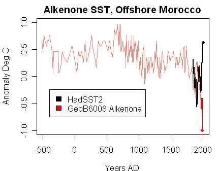
Re-plot of McGregor et al alkenone SST estimates.
Here is a plot of the inverted McGregor data, smoothed to more or less match the Trouet graphic.

However, unlike the Palmyra coral SST, Trouet inverted the orientation of Cape Ghir, plotting SST upside-down! Indeed, vsually, the upside-down Cape Ghir series provides the most vivid proxy illustration of 20th century “warming”, even though it actually goes down.
We also encontered this situation with Moberg’s G. Bulloides series from the Arabian Sea. As previously observed at CA, this is an indicator of cold water (upwelling), every bit as much as the Cape Ghir alkenones. Moberg also inverted this proxy and used it as evidence of 20th century warming.
Having said that, both Cape Ghir alkenones and Arabian Sea G Bulloides provide evidence of 20th century upwelling being outside the MWP range, for whatever that’s worth – “unprecedented” since earlier in the Holocene, I guess.
Trouet, V, Esper J, Graham NE, Baker A, Scourse JD, Frank DC (2009) Persistent positive North Atlantic Oscillation mode dominated the Medieval Climate Anomaly. Science 324, 78-80. (pdf) SI


20 Comments
I am as dumbfounded as is possible to be.
Everyone just flips the data when they want? Is there any explanation in the paper?
Re: Jeff Id (#2),
no explanation or even disclosure of the flip. The article is online (See link added to reference) if you wish to verify.
With the power to cherry-pick to “enhance the signal” and to invert when it helps the trend, the Team has to power to discover any outcome they want.
Re: Clark (#3),
That would be to “enhance the desired signal”. Let’s get it right, people! 😉
It even funnier – the cooling was caused by the warming:
“Near-shore waters along the northwest African margin are characterized by coastal upwelling and represent one of the world’s major upwelling regions. Sea surface temperature (SST) records from Moroccan sediment cores, extending back 2500 years, reveal anomalous and unprecedented cooling during the 20th century, which is consistent with increased upwelling. Upwelling-driven SSTs also vary out of phase with millennial-scale changes in Northern Hemisphere temperature anomalies (NHTAs) and show relatively warm conditions during the Little Ice Age and relatively cool conditions during the Medieval Warm Period. Together, these results suggest that coastal upwelling varies with NHTAs and that upwelling off northwest Africa may continue to intensify as global warming and atmospheric CO2 levels increase.”
If upwelling is the cause of decreasing temperatures as measured by proxies, then the question is whether this upwelling is a sign of increasing temperatures elsewhere or not. If it is, then it makes sense to invert the temperatures to proxy SSTs elsewhere. But I’m not convinced that’s the case. I don’t feel like going back and re-reading the old threads on the subject, but it seems to me that by definition increased upwelling in one place must be matched by increased downwelling somewhere else. The only thing I can think that would cause increased downwelling from higher temperatures is increased salinity. But I don’t see how in most areas this is likely. Water may evaporate, but it will cause increased rainfall and/or run-off. True there can be currents which would move denser water to different areas, but how do we tell changing current temperatures from changes of current locations, etc.?
More likely, increased upwelling would be associated with ice accumulation or melting, which can change salinity with more permanence.
Can I make a request to the software guru on this site?
I typed an inquisitive comment about two paragraphs long and neglected (forgot) to include my name and e-mail before submitting. I got an error screen but in the process the text was lost. One of those things I guess but perhaps a modification to the software could prevent this slightly irritating “glitch”.
Re: Heath (#7),
Lets see what happens.
[click]
Don’t see much of a problem, web site complains, hit the browser back button and type this here.
Heath,
If you value your thoughts, compose your post on a word processor first, save it, then cut and paste into whatever web editor you are posting to. This way, if something happens to eat (or snip) your post, you have a backup/personal archive.
[I hope this OT post survives long enough to get to Heath. I don’t mind if it disappears later]
The Moroccan upwelling system is a very old and stable feature that has apparently been going on at least since the Pliocene. There is a Pliocene fossil site in Morocco that has Ostrich and Great Auk occurring together, which is about as unlikely a combination that you can think of. The Great Auk is gone, but I remember seeing a razorbill bobbing around in Agadir harbour, which is also rather odd in Africa.
A coastal uppwelling like this is presumably wind-driven, so I would expect the SST to reflect the amount of easterly or north-easterly winds more than anything else.
Re: tty (#9),
“…A coastal upwelling like this is presumably wind-driven, so I would expect the SST to reflect the amount of easterly or north-easterly winds more than anything else.”
Quite possibly. Or possibly reduced surface seawater viscosity downwind of the upwelling. (That requires some solar heating, but no wind anomaly. Seawater viscosity is 100 times more sensitive to temperature than, for example, density.)
Even so, using upwelling as a proxy for temperature seems like Byzantine logic. There’s no extant quantified correlation between total upwelling at Point A and total temperature anomaly at Point B, is there? Maybe that explains the Z-score juju stick…
Re: jorgekafkazar (#17),
again, this is NOT the first Team use of upwelling as a temperature proxy. Moberg initiated this pernicious practice with his use of Arabian Sea G Bulloides.
David Black, author of the Cariaco data set which was a good data set and promptly archived, turned up here once. He had viciously excoriated Soon and Baliunas for using Cariaco G Bulloides as a temperature proxy. I asked him to comment on Moberg’s use of G Bulloides, an upwelling proxy in the Arabian Sea. Unfortunately, that was the last time that he showed up here, as, for some reason, he didn’t seem to want to explain the inconsistency.
Re: Steve McIntyre (#18), Yes, more teleconnection mumbo-jumbo: qualitative hand-waving without correlation. Even assuming a small, positive correlation between upwelling hither and temperature thither, the amount of heating need not be at all significant. The unstable temperature anomaly could be so minuscule as to make the proxy meaningless, as well as transient.
JamesG cites:
This is an amazing implicit affirmation of those major historic temperature changes by Trouet et al. This is especially interesting after the effort to use the hockey stick graphs to erase all memory of the Medieval Warm Period prior to “industrialization”.
Sorry if my complaint brought the thread off topic. If it needs to be deleted I understand the desire to have an uncluttered article. Not so much a complaint as an observation. I was using another computer. My home computer seems to keep the field information saved where my work computer doesn’t.
Hitting the back icon on my browser erases the text. Good suggestion about using microsoft word. Believe me I’ve done that before but sometimes i get hasty 🙂
Still, an improvement oportunity is there for someone with the desire. Thanks!
Heath, you don’t need to use Word. Notepad will do just fine.
Steve M,
Interesting interpretation of ITCZ shift as opposed to cool-MWP precipitated by NAO shift. It is worthy of mention that ITCZ – unlike NAO etc – is NOT merely a post-hoc eigenthingy, but a robust feature of the global circulation readily evident in all GCMs. Any changes in climate that can be attributed to shifts in something physical (as opposed to algebraic, possibly imaginary) is very, very interesting. Beats me why it is not in fact the null hypothesis.
Re: bender (#15), This statement:
Is sort of true, but models actually do you one better. They simulate two ITCZ’s:
http://www.co2science.org/articles/V11/N15/EDIT.php
Presumably some kind of program was used to produce these graphs. I’ve never come across one that would allow data to be inverted, so how was it done?
Any ideas?
3 Trackbacks
[…] This article on Climate Audit really gets at an issue that bothers many skeptics about the state of climate science: the profession seems to spend so much time manipulating numbers in models and computer systems that they start to forget that those numbers are supposed to have physical meaning. […]
[…] This CANNOT be the behavior of honest men or good scientists. Steve McIntyre has discovered that in some temperature proxy data series, the “scientists” have gone ahead and inverted a series that points the wrong way. If you can parse advanced statistical analysis, go ahead and read the original article. […]
[…] a very high-resolution alkenone series offshore Morocco (about 30N) by Helen McGregor (see here and here). This dataset had a serious divergence problem, i.e. the water was getting colder. McGregor […]