A couple of days ago, I posted up my attempt to replicate Emanuel 2005 Figure 1 (Atlantic PDI) and today post up a similar exercise on W Pacific PDI. While most hurricane discussion is focussed on the Atlantic, the PDI in the W Pacific is about 5 times larger. Emanuel said:
I maintain that current levels of tropical storminess are unprecedented in the historical record and that a global-warming signal is now emerging in records of hurricane activity This is especially evident when one looks at global activity and not just the 12% of storms that occur in the Atlantic.
In his Reply to Landsea on the endpoint pinning problem, Emanuel said:
As it happens, including the 2004 and 2005 Atlantic storms and correctly dropping the end-points restores much of the recent upswing evident in my original Fig. 1 and leaves the western Pacific series, correctly truncated to 2003, virtually unchanged….
Here is Emanuel’s Figure 2 showing PDI for the W Pacific against SST:

Emanuel 2005 Figure 2 | Annually accumulated PDI for the western North Pacific, compared to July–November average SST. The PDI has been multiplied by a factor of 8.3 * 10^-13 and the HadISST (with a constant offset) is averaged over a box bounded in latitude by 58Nand 158 N, and in longitude by 1308 E and 1808 E. Both quantities have been smoothed twice using equation (3). Power dissipation by western North Pacific tropical cyclones has increased by about 75% in the past 30 yr.
Below is my attempt to replicate the Figure using the archived Best Tracks data, done the same way as the Atlantic data. In the case of Atlantic storms, I gather that it’s not expected that there will be major additions to PDI during the balance of 2006; I have no idea what people expect in the W Pacific – so the 2006-to-date value is just illustrative. One difference between the graphics pertains to an adjustment to pre-1970 data by Emanuel, which was discussed by Landsea in his Comment. The Emanuel adjustment was based on Landsea 1993, but the adjustment is in controversy as discussed below.
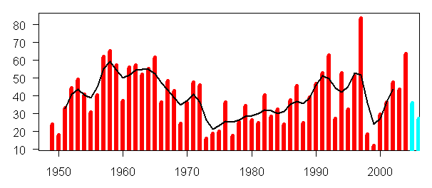
Emulation of Emanuel 2005 Figure using Archived Data
Next here is the extension of smoothed data to 2005 and 2006 – again note the caveat on 2006 data expressed above.
Any impression of a "doubling" in recent years derived from this data obviously derives entirely from the adjustment to pre-1970 data applied by Emanuel. I get the impression from Landsea’s comments here (and also Landsea 2004) that his current view is that it’s the 1970-1990 data that need to be adjusted upward rather than the pre-1970 data being adjusted downward. As between the two scholars, I get the impression that Landsea is much more immersed in the data – a characteristic that I obviously believe to be important. At the end of his Reply to Landsea, Emanuel stated:
But I agree that there is a pressing need for a storm-by-storm reanalysis of tropical cyclones, not only in the North Atlantic, but also in the western North Pacific, where aircraft reconnaissance records also extend back to the 1940s.
In a recent article upon which I’ll post shortly, Landsea questioned whether the hurricane data set contained too many inhomogeneities of methodology and instrumentation to permit trend analysis – a question that I hope to return to some time.
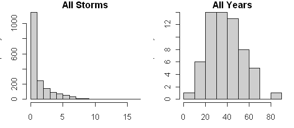
The histogram of hurricane PDI and annual W Pacific PDI are shown below and look a bit different than the corresponding distributions for the Atlantic – the annual distrubtions are less skewed.


31 Comments
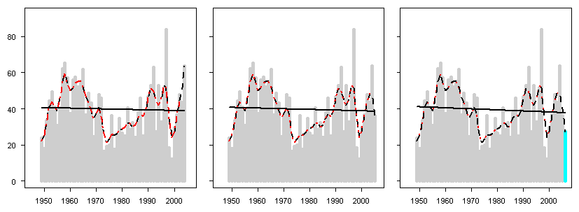
One small oddity is that Emanuel starts his Figure 2 PDI curve in 1955, but in Figure 3, which combines Pacific + Atlantic, he starts that combined PDI curve in 1950. Why not show all on Figure 2?
Another oddity is that his Figure 3 has PDI as the solid line, whereas Figures 1 and 2 have PDI as dashed lines. That makes it hard for me to glance back and forth and compare the three figures. The only thing I can guess is that there’s some visual impression about the Figure 3 SST or PDI he may want to make less apparent. Head-scratcher.
In reading the various hurricane papers, pro and con, Emanuel’s are the only ones that have that slippery feeling.
Here is a link to an article by Jeff Masters, the founder of Weather Underground (big internet weather site) and a former tropical meteorologist.
The article, which is an easy read, discusses the storm intensity controversy, including the Pacific issues.
Masters would be considered a “warmer” in most GW topics, a position he has made clear on his website. However, in the issue of tropical cyclone intensity, an area in which he has some expertise (including almost dying in a storm whose intensity was misjudged), I think he’s closer to the “skeptic” school of thought.
Re: 2
Masters may be a “warmer” but he clearly wants conclusions based on sound data.
I would be interested in Judith Curry’s explanation of why Emanuel assumed that the Northwest Pacific typhoon data in the 1950s and 1960s overestimated intensities and should therefore be adjusted downward. The effect of this assumption, at a minimum, is that it accentuates a trend of increasing intensities over the past 50 years.
Re #3 Emanuel made this adjustment based upon the recommendation Landsea (1993), this is not something that emanuel made up. I posted on this fairly extensively on another thread, but I’ve lost track as to which one. Subsequent to Emanuel’s publication, Landsea then stated that the correction should not be used. Emanuel then said he slightly overdid the correction, but not by much. This remains an unresolved issue.
Maybe the exact details are unresolved, but Emanuel deferred to Landsea in the last communication. I think if the issue is still unresolved, he should have hashed out and showed the differences rather then deferring. As it is, to maintain the difference after giving in, seems passive aggressive. Of course I think points should be pursued all the way to the end.
BTW, willis nice job on your analysis
Judith, I’ve been looking at the Landsea 1993 adjustment and plan to post on it. From looking at tree ring data, I’ve gotten into the hanit of paying close attention to adjustments – especially when the entire result depends on adjustments. All parties seem to agree that there are important inhomogeneities in the record. Particularly when this is the case, meta-data needs to be carefully documented and archived as well – it should anyway.
#6. Actually, this is moi starting to get into the hurricane data. Willis’ graphics format are a little different than mine.
It’s interesting that the PAcific distribution of annual PDI is less skewed than the Atlantic distribution. I wonder if the annual distributions are consistent with some kind of compound distribution in which there is a Poisson process for the number of hurricanes with a draw from the negative exponential looking storm distribution. Actually the storm distribution looks like the right tail of what is presumable the distribution of “depressions” – I presume that there are far more depressions than storms and storms are themselves a type of extreme event.
Steve and Willis, the hurricane data definitely needs auditing. Yes Chris Landsea is the “expert” on the historical NATL data. Kerry Emanuel told me that he was enormously frustrated in trying to make sense of WPAC data.
This past summer, when i started looking at the NATL data in earnest, the two students (James Belanger, under grad, and Mark Jelinek, first year grad student) working on this became enormously frustrated by the internal inconsistencies in HURDAT data set. This study resulted in a ~20 page document to the HURDAT Best Tracks Committee describing these discrepancies. The HURDAT data has now been changed to incorporate the issues raised by the GT students (see http://www.aoml.noaa.gov/hrd/data_sub/re_anal.html). Kudos to the GT students, but this really raises the issue of the quality of this data set. Outsider users (e.g. Emanuel, WHCC) and outside auditors (e.g GT students, climateaudit) are badly needed to smoke out these data issues.
Actually “fixing” the data is then another story. I am rather worried that the only people with “voting rights” on the HURDAT Best Tracks committee are NHC employees. A broader spectrum of people involved in this would be far preferable.
Steve, I am with you on “adjustments” to the data. WHCC used the data in raw form (Landsea noted 4 storms in the IO that we didn’t include, we accept that adjustment). At the same time I do recognize that there are problems with the processing of the satellite data that may contribute to the trend. But sorting through this in a rigorous and credible way, given the politicization of the issue, will be a considerable challenge. Unlike the the hockey stick data, where the community seems to stick together on the data quality, re the hurricane data you have research community already arguing over the data.
while i totally encourage the auditing of the data, since that whole issue is a bit of a black hole, i encourage you to start with auditing the statistical analysis of the data set actually used by emanuel. I am very interested to see what you come up with.
What you say above is what finally fell out of the Emanuel 2005 analysis here. When one sees what appears to those of us looking for these weaknesses as rather casual defenses of the adjustment uses, it leads me to think that the authors using them are not sufficiently aware of all the implications.
Those adjustments need further analysis, but can be separated from the other critical analyzed issues in Emanuel 2005 of the (a priori ??) choices of curve smoothing and neglect of autocorrelation effects.
re: #8 Steve,
Since you bring up that the storms are likely the tail of a process, let me present something.
I was wondering a while back what exactly the PDI tells us about movement of A heat and B moisture from 1. the ocean to the atmosphere 2. from the lower atmosphere to the upper atmosphere and 3. from low latitudes to high latitudes. After all, the main purpose of us trying to quantify hurricanes and tropical storms is to see what they can tell us about what relationship they would have to a putative AGW. One aspect of that, but by no means the most important, IMO, is that they’d give us an indication of future damage from storms.
But other aspects of storms is that they speed up the movement of moisture to the top of the atmosphere, thus letting heat be released where it can more readily be sent to space. Likewise as the tracks of the storms move north (or south) they move heat to where there’s less of a problem with them sending heat to space. So do storms actually have much of an overall effect or is it simply that they concentrate something that’s otherwise diffuse into one smallish area? Does a potentially large number of smaller systems actually do just as well in getting rid of the earth’s heat?
I know that there are small thermals both over land and sea which allow hot air to rise and cold air to fall. But if a tropical storm combines the power of 1000 such thermals does it multiply their effects or does it serve as a bottleneck or does it have no real effect?
Steve, re the histograms (i cant tell what is what from your plots), i suspect that the NATL and WPAC are different owing to the fact that you have a bigger range in the number of storms and number of storm days (which enters into PDI calc) in the NATL than in WPAC. this could easily be checked i think.
Steve, most depressions, probably 70% to 80%, do grow to become tropical storms or hurricanes. However, the number of seedlings (“easterly waves”) are rather constant year-to-year.
I don’t recall the exact numbers, but perhaps only 10% of easterly waves transform into tropical cyclones. Seedlings (easterly waves) may be what you’re seeing, with cyclones as the tale of the distribution.
Easterly waves are the seedlings for the Atlantic and Eastern Pacific. I don’t know about the Western Pacific.
(Interestingly for me, there is a seedling about 300 miles south of me this afternoon which is trying to transform into a depression. If it succeeds and grows a bit, perhaps it will be the 10’th storm of the Atlantic season and add 0.1 to the 2006 PDI.)
On your “skewed” observation, one difference between the Atlantic and Western Pacific is that the ITCZ ( a roadway for seedlings) travels very close to South America. If the ITCZ is over South America, then the seedlings can’t become depressions. That makes a noticeable difference in the Atlantic numbers, as South America covers about half of the length of the Atlantic. If the ITCZ is over water, then the seedlings can develop.
A slight southward shift in the mean location of the ITCZ, to where it is over South America, snuffs out a lot of potential depressions.
The mean location of the ITCZ varies year-to-year by a few hundred miles. Those few hundred miles can make a big difference in a season’s storm count.
Re 313 Poorly written by me. Steve, please delete. If it becomes relevant later, I’ll rewrite.
#14. I thought that it was pretty interesting. Do you mind leaving it up? The location of the ITCZ seems to me to be a very interesting datum in paleoclimate as it seems to connect to the slight asymmetry in hemisphere energy distribution in an interesting way. Presumably in the Holocenen Optimum when the IOTCZ was further north there would have been more Atlantic hurricanes – something which sparse paleo-data seems to indicate.
Steve and David, a quick reply re easterly waves and ITCZ. much research is underway on both. TCs can form from easterly waves, or not. in the NATL, virtually all of the major hurricanes originated as easterly waves (not the case in the pacific). In the NATL, the number of easterly waves is realtively constant; what varies is the number that become TCs. in 2005, the % of easterly waves becoming TCs was very high. Re the ITCZ and hurricanes, several theoretical studies are underway involving intertial instability. Digging into easterly waves and inertial instability is much harder work than counting storms, so it may take some time before this new work is published.
Re #15 Yes, that’s OK. My explanation is not as precise as it should be, and if it ever becomes something on which details are needed, I’ll rewrite.
Judith’s coworker, Webster, has done very important research on seedlings.
Re 13, 16 Easterly Waves
You may find this interesting.
THE STRONG ASSOCIATION BETWEEN WESTERN SAHEL MONSOON RAINFALL AND INTENSE ATLANTIC HURRICANES
By Christopher W. Landsea and William M. Gray (1991)
my bold
Dave D., you say:
Perhaps Judith could enlighten me on this. I can’t see any mechanism whereby hurricanes can move much heat. A hurricane picks up heat, both latent and sensible from the ocean, with the latent component being far larger than the sensible. However, in general, it moves that heat up, not poleward. At the top of the clouds, the water vapor condenses and falls, and the heat of condensation radiates out to space.
The cold, dry air at the top of the hurricane moves towards the subsidence zone of the Hadley Circulation at about 30°N and south. Presumably, if the hurricane at this point is poleward of 30°, the movement is towards the Equator.
But where is the mechanism to move any great amount of energy polwards? Yes, the storms move polewards, but on a scale of days/weeks, while the upwards movement and its radiation to space/falling as rain take place on the scale of minutes or hours.
w.
David Smith, thanks for your comment here citing the Masters paper. It is the clearest exposition of the subject I’ve seen.
w.
re: #19
Well, perhaps I don’t understand enough about how hurricanes operate, but my thinking is based on how hurricanes dissipate as they move over land. The storm tracks are mostly toward the north. And the large amount of precipitation deposited follows the storm track for thousands of miles quite often. Surely this energy has to come primarily from heat absorbed from the sea surface as the hurricane was forming before reaching the shore. Sure a lot of water is redeposited as precipitation as the storm moves over the sea surface, and replaced by more evaporation as it goes until it finally gets to low temperature water, but the fact that it takes so long for the precipitation to all fall out over land shows that there’s quite a stockpile, quite irregardless of the amount absorbed vs the amount released.
As I say, perhaps I’m all wet in this analysis, but that’s what it looks like to me.
Re 21, Dave, I don’t know either, that’s why I asked. However, remember that the falling rain is cold, not warm. It has given its heat up to the top of the atmosphere. In addition to direct cooling, the rain cools the land even more when it evaporates after the storm has passed …
So my guess is that overall, the storm is cooling the land, not warming it.
w.
#18,
I wonder then if the quantity of rain over W Africa then affects the amount of Saharan dust that moves across the Atlantic during the hurricane season. It seems as though it would. This year, there was a large amount of dust/dry air over the Atlantic, which became entrained into many of the systems forming during the Cape Verde season. This limited/precluded development of many of these waves into tropical cyclones. This also seems to be an effect of the inital location of the wave as it moves off the African coast. It seems that many of the waves this year were a bit further N and closer to the Saharan dust, which allowed the waves to ingest the dry air and kill them off. If the storms had been a few degrees further S, they would have had a better chance of forming into depressions.
#15 #14 The ITCZ is related to what was traditionally called the Heat Equator. Because it does not coincide with the geographic Equator any weather phenomena experience different degrees of rotational forces which increase from zero as you move away from the equator. These forces are important to development of the closed rotational systems that are hurricanes. They must also have an influence on the Hadley Cell circulation. It is ironic that little research has been done on the ITCZ which emerged from the Hadley Cell concepts of Halley and Hadley in the early 18th century. Most texts show it is a line but it’s really a zone between two cells that migrate with the sun and as noted, the movement varies from year to year. It is also amazing how people attempt to make predictions without this knowledge. It is also more amazing how they try to build computer models without this knowledge. But it is the same problem with the Polar Cell and the polar front. I read comments about outbreaks of cold air and snow in Buffalo with little mention of the pattern of Rossby Waves and their variation in number and amplitude. Indeed, I see so much discussion of specific issues with no apparent understanding of global climate or the limitations in knowledge.
RE: #3 – If anything, I’d trust the data for the NW Pacific during the 50s and 60s more than more recent data. Consider all the US military meterologists who were on the ground in the area at the time due to Korean War, Vietnam War, Cold War tensions.
#23 Jonathan, any thoughts as to whether your line of reasoning re the dust result in positve correlation between SST and # of TCs, or a negative one? If you can provide some insight into that, then maybe this line of thought can provide some insight into the dispute surrounding the M/E paper
NPR piece from this morning.
Off Africa’s Coast, a Hurricane Nursery
During the 2006 hurricane season, a group of scientists spent a month in Cape Verde to learn more about the birth of these storms.
RE: #27 – One good downdraft and you’re cartwheeling wing to wing across the sea surface into a tangle of metal. I wonder what sort of insurance those folks can get? 😉
#4. Judith, you’re incorrect that Emanuel based his Pacific adjustment on Landsea. His Pacific adjustment is one he developed himself, as described in his SI.
Steve, you are correct, it is only the NATL adjustment that is based on Landsea (1993).
The Pacific ocean temperature buoy systems have been taking quite a beating.
Google for more, going back years – damage by fishing boats, vandalism, pirates, and straightforward removal and theft of instruments; just one example:
http://www.pmel.noaa.gov/tao/disdel/disdel.html
“TAO moorings in the eastern Pacific (95°W and 110°W) have been heavily vandalized since June 2006. These moorings are scheduled for replacement in November 2006. Recent graphical displays of TAO / TRITON data have been adjusted to account for data void regions east of 125°W.”