In my continuing search for updated dendroclimatological temperature proxies, I started by looking at what had been archived at ITRDB; this has proved to be a very disappointing source of candidates. I’ve re-canvassed some literature for candidate unarchived information. In an email, Connie Woodhouse mentioned that their efforts with upper treeline sites in the U.S. had not yielded any useful results. Our occasional and valued correspondent, Rob Wilson, is very much at the center of upper treeline dendro studies in Canada, making our occasional visits with him all the more valuable. Luckman and Wilson 2003 contains the following useful short synopsis of upper treeline studies:
Dendrochronological studies at upper treeline in the southern Canadian Cordillera have focused on either Vancouver Island (Smith and Laroque, 1998; Laroque and Smith, 1999) or the Canadian Rocky Mountains (Parker and Henoch, 1971; Luckman et al., 1985; 1997; St George and Luckman, 2001). Only two treeline spruce chronologies are available from the large intervening area (Schweingruber, 1988). Recent work in the southern Rockies has established networks of chronology sites using Engelmann spruce (Picea engelmannii Parry), whitebark pine (Pinus albicaulis Engelm) and alpine larch (Larix lyallii Parl) that typically average 300—400 years (Luckman, 1996) but include millennial-length chronologies from each species. Temperature reconstructions have been developed from some of these data using alpine larch (Colenutt, 2000) and Engelmann spruce (Luckman et al., 1985; 1997; St George and Luckman, 2001).
In 1998 a network of 20 new Engelmann spruce chronologies was sampled from sites across southern British Columbia (Figure 1). All sites were at or within 100—200 m of upper treeline, including sites at Kokanee and Kootenay Pass close to the two chronologies sampled in 1983 (Schweingruber, 1988). An additional ring-width chronology was developed for Harts Pass in Washington State from five spruce chronologies sampled in 1992 (Peterson and Peterson, 1994).
Disappointingly, none of the new Canadian measurement data has been archived; only one chronology (the updated Athabaska chronology) has been archived, though oddly enough it does not appear in the ITRDB archive but in the more general WDCP reconstruction archive. As time permits, I plan to post up short excerpts from each of these studies trying to work back as much as possible.
Today I’ll start with Smith and Laroque 1998, the first paper on the list.
I’ve tracked down Laroque and Smith 1998b, Mountain hemlock growth dynamics on Vancouver Island, which is available online, but haven’t tracked down Laroque and Smith 1998a, High-elevation dendroclimatic records from Vancouver Island, which is a workshop presentation. I’ve reported here on Laroque and Smith 1998b, which I presume to be an alternative presentation of the same sites. I’ll try to doublecheck this at some point and, if this assumption is misplaced, I’ll note that here. In the meantime, the sites described in Laroque and Smith 1998b are all high-latitude Vancouver Island sites and appear to be pertinent to the brief survey in Wilson and Luckman 2003.
In 1994, Laroque and Smith sampled four Vancouver Island sites: Circle, Canyon, Milla Lake, Delight Lake. (See map in link). Three of the sites were above 1500 m; the latter two sites were within a km of Aureole ice field. None of the measurement data has been archived, but it is only 9 years since the study.
The authors report that ring widths are sensitive to changing climate, but describe a complicated response surface in which growth is maximized in cool summers with a small snowpack, but with a secondary and much lesser maximum in warm summers with a large snowpack. Laroque and Smith:
the radial growth of mountain hemlock trees growing at high elevation on Vancouver Island are sensitive to changing climate … the greatest increments of radial growth occurred during cool summers that began with a shallow snowpack, while the least amount of radial growth occurred during seasons that began with below normal snowpacks and ended with very warm summer air temperatures (Figure 3). Significantly, our analyses demonstrated that when the seasonal snowpacks exceeded 4 m in depth, radial growth was significantly reduced, regardless of the growing season temperature (Figure 3).
Here is the diagram of their response surface and you can see how complex the relationship between ring width and temperature-snowpack is:
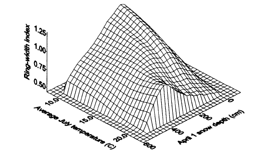
Original Caption: Figure 3. A response surface expressing the relationship between the annual mountain hemlock radial growth indice, average July air temperature and April 1 snow depth. Due to nonlinearity in the climatic variables, the 40 data points used were smoothed before modelling using second-degree polynomial equations. The figure indicates that between 1954 and 1994 enhanced radial growth occurred during cool summers that began with shallow winter snowpacks, or during warmer-than-normal summers that began with moderately deep snowpacks (< 4m).
They provided the following graphic for their ring width chronology (it’s smoothed and is the higher; the authors show an El Nino chronology for comparison). It is obviously impossible to inverting the ring width chronology to obtain a temperature estimate using linear methods (such as principal components, rotated principal components or regression) and the authors did not do so in this particular article. All we can say at this point is that Laroque and Smith 1998b do not show a HS-shape signal and, to that extent, do not serve as evidence for the IPCC SPM claim that updated studies provide “additional data showing coherent behaviour across multiple indicators in different parts of the world.” I’m not saying that this data is relevant to vexed issues such as the MWP; I’m merely canvassing dendroclimatological literature (other than that from the main players on the Hockey Team) to see if it supports the SPM claim.

I’ll post up some notes on the other upper treeline articles over the next few days.
References:
D.J. Smith webpage
Smith, D.J. and Laroque, C.P. 1998a: High-elevation dendroclimatic records from Vancouver Island. In MacIver, D.C. and Meyer, R.E., editors, Proceedings of the Workshop on Decoding Canada’s Environmental Past: Climate Variations and Biodiversity Change during the Last Millennium, Downsview: Atmospheric Environment Service, 33—44
Smith, D.J.; and Laroque, C.P. 1998b. Mountain hemlock growth dynamics on Vancouver Island. Northwest Science 72 (Special Issue 2): 67-70. http://www.geog.uvic.ca/dept/uvtrl/nws98.pdf


13 Comments
If the AVERAGE July temperature is 20 C, then it’s a pretty safe bet that the trees are seeing temperatures during the day that are way over the 20-25 degree optimum. Downside part of quadratic for sure. Of course, by July maybe most of the growth spurt is over (just latewood formation), so I wonder what the May and June averages were. Deep snowpack in April suggests that the spring growth spurt is delayed, and when growth finally does start, temperatures are above optimum. That would explain variation with snow pack. This response surface is great in that it shows how so many variables can affect tree growth. I still say that it is challenging almost to the point of hopelessness to try to tease a temperature signal out of tree ring data.
I wonder what the response surfaces for White Mountain BCPs and Eastern Sierra Foxtail sites would look like?
#1, jae
Looking at the response curve, the ring width is nearly independent of the temperature.
Followup to 1: One would think that one of the a-priori site selection criteria would be to pick a site that did not have such high summer temperatures!
As one who’s studied general climatology but not dendro I find it fascinating that ring widths are still trending upward with decreasing July temperature as the latter reaches 10C. I’m used to thinking of that as the (approximate) temperature below which trees won’t grow at all.
RE: #5 – Certainly, the latitudinal tree line roughly follows the 10 C mean annual isotherm. (Or is it 5 C? – a bit rusty of the top of my head). In any case, that isotherm is determined by a number of factors, which also, in and of themselves, affect growth. Two I can think of straight away are sun light / sun angle and north winds. It could be that the latitudinal tree line may be more a reflection of those factors than it is a reflection of mean temperature per se.
Thanks, Steve. I should be clear that I’m not suggesting there’s anything questionable about it; it’s interesting, that’s all.
Personally, I’d imagine trees on Vancouver Island probably can be in growth mode clear down to freezing. Also, a year in which the mean temp hovers around or below 10 C, at that location, may correspond to a year where the snow pack survives longer into the summer. While certainly Vancouver Island does not have an outright summer dry season as do areas from Central Oregon south, there is a summer precipitation minimum there.
That 1998 “paper” with the response surface was not peer reviewed (note: data points not plotted & surface fit statistics not reported). This one was, however: http://www.geog.uvic.ca/dept/uvtrl/hemlock.pdf
This paper reports on 10 locations, not just one. And there, the authors point out that warm, dry years are years when cone production goes up, thus limiting how much photosynthate gets allocated to radial growth. So don’t be too quick to judge the degree of nonlinearity in the response function.
jae: like a young grad student, you leap to conclusions too quickly. You’re impossible to police! Try to read more.
Here is the graph on the 10 chronologies from the article that bender referenced. I’m inclined to say that it doesn’t show a strong HS pattern.
RE: #10 – Pretty interesting sequence of events of some sort, affecting Cascadian and more coastal sites, between 1830 and 1850.
Looks like there may also be some sort of delayed-by-1 year signal from the 1813 – 1815 cold event (or the event hit a year later on the West Coast than it did in the Eastern US). That one was a reponse to a volcanic explosion, IIRC.
Re #5 Look carefully at the graphic, esp. considering perspective. The increase in RW wrt Temp plateaus at ~15°C for all snow levels above 200cm. It is for snow depth l.t. 200cm where there is an increase from 15°C to 10°C, and it is only a small increase. (Note: Between 400 and 600 cm the temperature response is zero. Below 400cm most of the positive response to Temp is from 20°C to 15°C.)
A July temp of 10°-15° sounds cool, and it is. But the growing seasons there are relatively long, compared to more continental locations.
Also note: this response function is based on only 40 years of data, 1954-94. That’s not alot.
But I’m happy to report that the 2001 CJFR paper (http://www.geog.uvic.ca/dept/uvtrl/hemlock.pdf) uses bootstrap response-function significance-testing (Guiot 1991).