Anthony Watts writes:

The picture above comes to me courtesy of Gary Kobes, of the US Coast Guard. It is the temperature sensor at the climate station of record in Aberdeen, WA It is located at the sewage treatment plant. Note the sign on the support post. Note also the temperature shelter plates are clogged with some dark matter, what I’m not sure.
Gary writes: The general location is about 300-400 feet north of Grays Harbor—the body of water. The sewage plant is located in the middle of an industrial area. The sewage plant lies between the site and the harbor generally on the south. The heavy construction company’s yard building and equipment are to the east. Weyerhaeuser has a log yard to the west. The northern boundary of the site is a railway and on the far side is an area of light industrial buildings.
The measuring head is 6′ above the ground. It is about 25′ from the office building in the background. It is surrounded on three sides—the tree and out building about 75” to the southeast, the office building 25′ to the southwest and the #1 sewage digester and processing tank 90′ to the northwest—and sheltered from the three primary prevailing directions of wind in the area. The measuring head has a 25′ wide strip of grass on the southwest side and a concrete sidewalk and asphalt parking lot to the northeast.
Nothing like convenient parking next to a weather station, why I’ll bet those hot automobile radiators only affect the temperature a few degrees, not to worry.

This USHCN station is used in the GISTEMP database to calculate future trends in computer driven climate models. You can see it here:

I don’t know about you, but I think something smells about the data.
Steve adds:
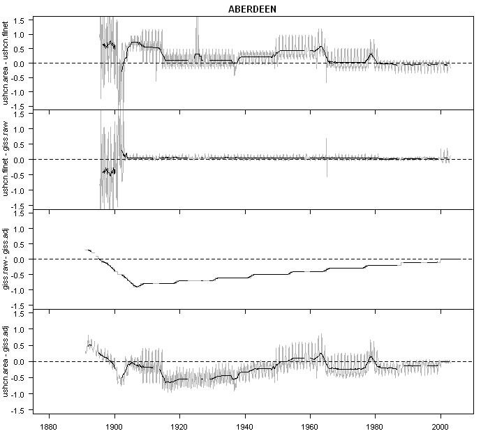
Here are a few plots from Aberdeen for context. Here are 7 versions of the Aberdeen series; Anthony has shown the GISS unadjusted version, which is pretty much identical to the USHCN adjusted and GHCN adjusted versions, which are probably what are used in CRU – though only the Shadow knows what CRU does. The GISS adjusted version allows for a substantial UHI effect – see difference between red and other series.

Here is a plot showing adjustments in a format that I’ve shown before: USHCN Raw- USHCN Adjusted; USHCN Adjusted – GISS Raw; GISS Raw – GISS Adjusted ; thus USHCN Raw – GISS Adjusted. You see that the UHI allowance between early 20th century and modern values is up to 1 deg C, notwithstanding Parker, but look at the attenuation in the late 19th century.
BTW in response to a question, Aberdeen shifted to MMTS in 1985. For some reason, Aberdeen station history is not at the MI3 site (why not?) but is decodable from http://cdiac.ornl.gov/ftp/ushcn_monthly/station_history .


82 Comments
what changed about 1985?? Murray
Aberdeen Washington is wet…really wet year round. The dark matter in the plates would probably be mold that essentially grows on anything and everything.
The pole supporting the MMTS sensor looks dark. It must heat up and act like a radiator just below the sensor. Are the poles metal or plastic?
Also the metal sign under the sensor will heat up quite a bit in sunlight.
#1. Murray, in Sept 1985, they changed from min and max thermometers to MMTS. They did not make any adjustments for the change in instrumentation. This is getting to be a bit of a joke.
I recall that the bias is supposed to be about 0.3 deg C, but I wonder how accurate that is.
Re #4
Steve M,
Hopefully Anthony will be able to validate that 0.3 C bias estimate with his upcoming tests. I suspect that there was more than just a change to the MMTS though. The pre-1985 station was probably located somewhere else, in a spot further from existing facilities. A common observation at surfacestations.org is that the MMTS installations are very close to buildings due to their cabling requirements.
That (estimated) 0.3 C bias was of the minima. The (estimated)
maxima bias was -0.4 C, and the average was -0.1 C.
I don’t have any idea how accurate their estimates were, but
it seems best to refer to their estimated average bias.
RE3, Doug
Yes it is a metal pole. I’ve seen two mounting schemes for MMTS stacked plate shelters. Metal poles (same as chainlink fence posts) as well as PVC pipe. The PVC pipe is white, and larger in diameter. I beleive you would be correct in assuming that a metal pole introduces a positive bias though I’m not sure of what magnitude.
The more I get pictures, the more experiments I have to do to quantify these things. My workload is stacking up.
As soon as I saw it, I thought the same as #2 – mold. Finding out that it’s on the “northeast” side (based on the description) is further evidence.
Re: 2 & 3 the dark matter is mold and the mounting pole is galvinized steel with normal oxidation. The back side of the sign is matte aluminum finish.
Also in checking the MMS website:
The station was relocated in Mar 1985 from a location 2 miles NE, where it had been since 1948 to a location about 1/4 to 1/2 mile WNW of the current site. Since that initial move it has moved in the general vicinity on Aug 2003 and in Apr of 2004 to its present position.
Also as a minor clarification I am a civilian and a member of the Coast Guard Auxiliary and was participating a logistics delivery when I had the opportunity to take these photos.
#9. Gary, I couldn;’t locate Aberdeen WA on this website http://mi3.ncdc.noaa.gov/mi3qry/ . Which website did you use?
Anthony you may have to buy a big Fan or leaf blower as well.
Steve, I used the guest login on the same website. I searched under Where: “county” and “grays harbor”. Hope that helps.
10 Steve, Aberdeen is a popular name and the name search only shows the first 10 hits. Restrict the name search type to COOP sites instead of all and Aberdeen WA will show up.
RE10, I had trouble finding it as well, it appears the search engine fails on ABERDEEN and also portions like “ABER” as well.
I found it by doing a search of all COOP stations in Washington after wading through several pages
here is the link:
http://mi3.ncdc.noaa.gov/mi3qry/identityGrid.cfm?setCookie=1&fid=28107
Additional photos from Gary’s survey are here:
http://gallery.surfacestations.org/main.php?g2_itemId=4658
And another sewage treatment plant aka USHCN station, Sedro Woolley, in Washington from Don Healy here:
http://gallery.surfacestations.org/main.php?g2_itemId=4388
And Everett, WA where the MMTS is in the middle of the city corporation yard. This MMTS has the PVC pole mount that I spoke of.
http://gallery.surfacestations.org/main.php?g2_itemId=3860
One thing I’ve been noticing about MMTS installations is that they vary in height significantly. Compare Everett, WA to this photo with proper observing height and to Aberdeen’s height. I don’t see any notes in MMS about changes observing height unless I’ve missed them somehow?
http://gallery.surfacestations.org/main.php?g2_itemId=1145
My personal observation of sewage treatment plants, on my daily drive past the Bonnybrook treatment facility on the banks of the Bow River in Calgary, heat generated by the biological activity and just the massive volume of water cycling through the facility causes a strong UHI effect, most noticable in winter when, even on the coldest days (-20-30C) the Bow is open downstream and filled with congregating waterfowl. The ducks like the green grass over the fermentation and settling tanks as it greens up even in Feb-Mar and is mostly clear of snow through the winter. A good spot for temperature measurements?
Locating a temperature sensing devise adjacent to a black asphalt coated parking lot is pretty helpful for determining whether an animal left in a car might be in danger. For other uses, not so great.
Yes, and right next to an aeration tank as in Anthony’s second link above, nice and humid all the time.
Re #58 noting the differences between indirect vs direct data:
A similar statement can be made regarding the paper by Quayle, et al, in determining the systematic differences between CRS and MMTS measurements which can be found here. In this paper the entire analysis was based on relating particular sites where the CRSs were replaced by MMTS instruments with some nearby sites which used the CRS housing continuously and then selecting that nearby site that showed the best correlation with the CRS record at the site where the instruments were changed.
It sems obvious that the right way to make a comparison would have been to have operated both instruments at the same site for a sufficiently long overlapping period to make the site comparison directly. For whatever the reason that wasn’t done, probably because the decision to compare the values was an afterthought which occurred some time after numerous sites had already been switched and the CRS devices for those sites were no longer available.
This proxy method might be regarded by some as valid on the grounds that it is comparing apples with apples, but there’s still a lot of difference been a McIntosh and a Delicious.
As for UHI data, perhaps one could compare the temperature trends of long-term, mature urban areas like NYC and downtown Chicago with more recent and rapidly developing urban sites like Phoenix/Scottsdale, Orlando FL, Las Vegas NV and Santa Fe NM., or the once rural suburbs of those mature UHI sites.
Whoops! Previous post #58 was on the wrong thread. I’ll put it where it belongs.
SAT
Also, note the cigarette dumpstand next to the station. It was noted that the station is about 25′ from the entrance to the building… no surprise that the ashstand is right there since the recent law requires smokers to stay 25′ away from any building entrance.
Imagine smokers huddled by the ashtray on any day of the year, right next to the weather equipment, come rain or shine or snow.
And yeah, Aberdeen, being by the water there, and that station being on the north side of the building, and the dark spots then being on the north part of the unit…yeah, that’s the typical green mold or algae or whatever typical in these parts. I get it on all my north-facing surfaces and have to pressure wash it off every year or two, otherwise it just builds up and builds up.
RE21 Great, smoking gets invovled with weather stations and a whole new batch of health legislation will get thrown at it, with money for studies earmarked too.
Just kidding, but it shows just how oblivious people are to the temperature measurement process.
I’ve noticed that a significant number of the USHCN weather stations are situated near sewage treatment plants. Of the six or so checked in Washington State thus far under Anthony’s project, three (Bellingham, Aberdeen and Sedro Woolley) are so sited. We have been looking at the physical characteristics of the weather stations, but is it possible that there is a chemical aspect as well? Does the sewage treatment process release CO2, methane, nitric oxides, sulfuric oxides and/or other greenhouse gases into the local atmosphere that could affect the temperature at the weather site? I noticed that Bellingham had a very well-situated weather station. However, the sewage treatment plant and the weather station sit in a niche formed by the surrounding hills on two plus sides, which could trap heavier gases under certain wind and weather conditions.
Just a random, late-night thought to consider.
Interesting paper would be the UHI-like effects of sewage treatment plants. Probably wouldn’t get all that many citations.
No. 24
It would take a well-funded group…someone flush with cash.
Notice the neatly groomed lawn surrounding the sensor. Watering will add additional bias, which will not only be seasonal, but depend on the time of day as well.
I’m not surprised at all now to see slightly higher daytime trends, but also much higher nightime trends. With adjacent parking lots soaking up the sun, hot cars during peak hours, and buildings that are heated during winter or just re-radiating all night long…..of course it’s getting warmer!
No. 21, 22.
How many of those smokers don’t know that the funny thing on top of the pole with the green mold growing on the northern side is a temperature measuring station? I can see them hanging around that pole or leaning against it. Or worse, imagine one of those smokers with nothing better to do does know that the funny thing is indeed a temperature measuring station. “Hey guys, what would happen to this here thermometer if we blow some smoke at it?
Re: #23
Don Healy said:
I’ve noticed that a significant number of the USHCN weather stations are situated near sewage treatment plants.
Add Ellensburg, WA to the list. It is located in a waste water treatment plant two feet from a driveway with that has tire prints three feet from the sensor. There is a churning pool of waste being treated less than 100 feet away from the sensor and a clear pool of water about 200 feet from the sensor. I would guess that wind direction might affect the temperature reading depending on whether the wind passes over the waste or over the clear pool.
I hit 12 sites so far but only have good data on six and partial data on three more. I will not be able to upload this until during the week when I get back. I want to get some aerial photos to pin down the locations and compare them to the maps on the NOAA website.
Re #25
John M,
Naw, such a study would be a waste.
/rimshot
Anthony Watts has caught the attention of the Drudge Report and Pittsburgh Tribune here.
The great work that you guys are doing over at surfacestations.org has drawn attention in the media via a headline on the drudgereport:
“Temps measured by NOAA weather stations possibly compromised due to faulty placement…”
http://www.pittsburghlive.com/x/pittsburghtrib/opinion/columnists/steigerwald/s_513013.html
Keep up the great work!
Congratulations Anthony
http://www.pittsburghlive.com/x/pittsburghtrib/opinion/columnists/steigerwald/s_513013.html
Woof
I’ve had to shut down the online photo database until this maelstrom of traffic passes.
My office net pipe is clogged. Will be back up at new location in 24-48 hours
Anthony, the Drudge Report reference may overwhelm your site for the better part of a week. A direct link from Drudge often results in a hit attempt rate of a million a day.
RE: #23 – Sewage treatment definitely releases GHGs. When there is an inversion, you’ll get something that truly is a greenhouse effect – a true blanket of GHGs. Even when there is no inversion, the higher GHG concentration in the area is going to have some effect on the radiation dynamics.
I would imagine that the chemical and biological activity in the treatment pond would also be generating a significant amount of heat.
Hey Anthony, Congrats on Drudge.
I’m sorry, I should have warned you. ( I’ll explain off line, drop me a mail)
Get yourself some google ads on the site. Get the tip jar going.
I have a bunch of other ideas for pumping up participation in the project.
ever make it to the silver dollar speedway?
Best, Steve
Anthony,
Get ready for an Instalanch. (www.instapundit.com)
I should have warned you.
Sorry.
What these photos tell me is that people in Aberdeen don’t know how to park between the lines 😉
RE: #37 – A local maximum in terms of both anthropogenic thermal dissipation and GHG concentration. The two often go hand in hand.
I found you through Drudge. It seems that the poorly-placed stations show temp creeping up over the decades. This could be because they gradually add the “improvements” to nearby structures & land — pavement, A/C, cook out grill, etc. Everytime something new is added, voila, temp. incs. slightly. My only concern regarding http://www.surfacestations.org website is he only has a few observations documented so far. I’m sure the “unchecked” remaining stations are now scrambling to clean up. Too bad. We should fan out with cellphone cameras to capture the TRUE state of these stations before “clean up” has buried important evidence of true state of these stations & the reliability of their measurements.
Re #42
Pam – I wouldn’t worry about the sites suddenly being cleaned up. The MMTS sensors are literally cast in concrete and could not easily be moved. What’s more, these sites have been around for decades and are basically a volunteer operation. There is very little money being spent on them so it is unlikely that there will be any money to clean them up. Furthermore, any big clean up would require the sites be moved. This would leave such terribly incriminating evidence that only an idiot would attempt this kind of deception. There are no NOAA clean up crews carrying “flashy thingies” (Will Smith, “Men in Black”) to erase the memories of everyone who saw them.
Finally, there is no pattern of placement versus warming so far. There is only a suspicion that such a connection exists. Remember that only a few sites have been monitored and not many have been analyzed statistically. One of the best sites that I found showed some warming while a site that looked like it could be a disaster showed a slight cooling. This is very preliminary and not based on any substantive analysis, only on a gross comparison of long term trends using “adjusted” data so please wait until the sites have been fully evaluated and compared to their records before drawing any conclusions.
At this point we are still in the data gathering stage. What little analysis that has been done is probably best thought of as providing the station auditors some help in determining what features to examine.
RE43 Well said Bob, I’m off Drudge, so site is back up and running 100% now that I won’t have traffic jam.
Moving server to colocation facility so that if it happens again, there’s enough pipe and it won’t take my business offline at the same time.
Pam.
We would love to have the sites cleaned up. The whole point of an Audit is to get people
to live up to their own standards. These sites fail to meet the standards set for them.
#45
I agree, but I do not yet see a silver lining in this cloud; instead, I find this story incredibly disheartening. Given the importance of sorting out all the uncertainties related to climate change, to discover such fundamental problems with the monitoring sites is incomprehensible.
Of course it would be good to clean up the sites, but that would not solve the problem with the historical data. Imagine for a moment that cleaning up the sites caused the average observed temperature instantly to drop/rise by one degree C. Would you be comfortable concluding that AGW does not exist/is worse than we knew? I wouldn’t.
What we thought were reliable data may turn out to be no more than an uninterpretable mess.
😦
#46. TAC, a particularly reprehensible aspect to this is that Karl et al 1995 (and doubtless earlier) explicitly stated the need to achieve homogeneity and continuity and some of the worst debacles in this network have occurred since then, some while Karl has had senior offices at NCDC.
Looks like Karl is attempting to turn NCDC into a business enterprise:
http://www.citizen-times.com/apps/pbcs.dll/article?AID=200770618107
On second thought, maybe there’s a place there for you Steve. With all that NCDC related business springing up, surely there’s a need for some AUDITORS.
I got out of bed to post this, because it was just one of those moments where the light bulb came on over my head and made it hard to sleep.
I was conversing earlier with a fellow who was going to do a survey of the Urbana OH WWTP (Waste Water Treatment Plant) USHCN site. I know there’s been a bit of concern about the number of WWTP’s that have been seen in the USHCN set. There’s also a fair number in CWO/GISS sets, Colusa, CA for example.
Colusa’s WWTP moved to a new, larger facility, and so did the USHCN temp sensor. I had trouble finding it because of that move. The new facility was about 3 times the size of the old one.
It occurred to me that temp sensors at WWTP’s are measuring population growth directly. The more waste-water, the greater the local bio-reactive byproduct heat plume, and the greater the humidity plume, and thus increased daytime and night time temps due to that heat and humidity plume.
Clearly, WWTP’s are not appropriate places at all for temperature monitoring stations. And this doesn’t even touch on the issues we’ve seen with parking lots, buildings etc.
But many USHCN and GISS stations are WWTP’s tracking temperature and rainfall because when the Mercury max/min thermometer needed reading, and the gauge dipstick needed reading, somebody had to be there to do it. Making it somebodies job where somebody would be on duty 24/7 fell to airports, police stations, fire stations, ranger stations, and yes, WWTP’s.
We need to count how many WWTP’s are in the station set. Anybody up for that?
Anthony has made it to NewsBusters
http://newsbusters.org/node/13549
and to today’s Junkscience.com
Re #50 Some WWTPs have moved to higher-capacity aeration blowers (= more warm humid air created). Perhaps a question to ask when surveying a WWTP is whether they are using original-capacity equipment.
Per your question, I’ll be glad to count. Are you referring to the ones at your webiste, or in another database?
My plan is to survey at least one more Texas station this weekend.
SteveM,
I had a thought. Currently, Anthony and company are going out on an ad hoc basis, finding
things here and there. I’ve been thinking about something after struggling through Parker.
Assume the UHI signal shows up strongest in Tmin. Take all the stations in the US.. or perhaps
by state. Calculate a Global Tmin Slope from say 1950 to present. Then calculate a Tmin slope
for all indivual stations. Rank the sites by changes in Tmin slope. Those with the biggest
upward change are good candidates to put on the audit list. Cherry picking? or creating
a priority list of sites to visit?
#53 Steven Mosher,
Judging from the reports todate, there is no need to cherry-pick to find the bad sites. The tougher job will be finding the good sites.
Cliff
RE: #50 – Lt. Columbo would be proud!
RE 55.
At least you didnt make any jokes about stuff hitting the fan.
Now relative to a “parkeresque” methodology, Suppose one bifurcated
sites into Waste Station collocation, and non waste stations.
Re: #36
Steve Sadlov indicated: “RE: #23 – Sewage treatment definitely releases GHGs. When there is an inversion, you’ll get something that truly is a greenhouse effect – a true blanket of GHGs. Even when there is no inversion, the higher GHG concentration in the area is going to have some effect on the radiation dynamics.”
Steve, do you happen to know of any studies that have been done on this issue? I’ve contacted several local waste treatment plants to see if they have any references on the subject of GHGs released during the treatment process. So far no luck. They acknowledge that the process certainly releases them but have no idea as what what the concentrations of these gases might be under various conditions in the immediate area of the plants.
RE: #57 – I know of no studies. Hopefully some will be funded in the future.
RE 54.
I’m not really concerned about a cherry picking issue. PARKER has already
claimed that the UHI signal should be in Tmin. He looked for it under windy/calm
I’m just using his strategy. If the trend in TMIN increases for a site more than the global
average, thats a signal of UHI increase at that site. I’m just hijacking his method.
So, use Tmin Slope to Rank sites 1-n
Then, one looks at the actual sites at both ends.
The current approach finds bad stations randomly. And the search is subject to objections like
1. you didnt look at enough.
2. you looked in areas close to you.
I’d suggest a two pronged search. Sites where the local tmin slope diverges from the global Tmin mean slope
in the positive direction ( sites that are getting hotter than the norm) and sites that are getting cooler
from the norm.
SO, AUDIT the tails…
Supposition: the hot tails will be microsite impaired. The cold tails will be QUALITY sites.
use the CRN site criteria ( 1-5)
Basically.
1. We assumed, after Parker, that Increasing UHI would be signalled most strongly in TMin.
2. Sites were ranked according to slope of Tmin increase over a 50 year period.
3. Hypothesis: Sites expereincing the highest rate of Tmin increase will NOT be quality
sites per the CRN scoring system
4. Hypothesis: sites expereincing the lowest rates of Tmin increase WILL be quality sites
per the CRN scoring system.
5. Estimate the distribution of Quality in the exiting sites ( how many 1, 2,3,4,5s)
Or something like that
RE55, Steve Lets just call it a “poop de Grace”
😉
RE59, Steve I think this is an excellent approach, but I do have concerns about appearances of “Cherry picking”.
We must get all the USHCN sites, or a very, very, large majority at the least, surveyed to back up any claims problems system wide. We may find some sites that we won’t be allowed to survey. Such as Reno Airport for example, due to security issues.
I’m moving the server tomorrow to a new location, hopefully we can pick up where we left off with greater bandwidth.
57: There must be a LOT of methane released by sewage treatment plants. Of course, it’s lighter than air and probably vanishes quickly.
I’ve posted up a collation of USHCN min temperatures in an R-format here (10.3MB). I don’t have time to make things transparent to Excel users (which people shouldn’t be using for data analysis anyway). You should be able to retrieve the object as follows:
This gives a list-object
[[1]] raw
[[2]] tobs
[[3]] filnet
Each of the three is a monthly time series object going from 1598 to 2006 in which there are 1221 columns representing the 1221 USHCN stations. You can retrieve an individual station as follows (for example)
I’ll probably save these as tab-separated ASCII files at some point but this was a titch quicker to do. The collation itself took a long time running in the background.
Is there anyone in the D/FW area that would interested in finding a few sites? I don’t have GPS but do have a nice digital camera for grabbing pics. I know there is at least one station in Denton, though not exactly sure where. If anyone is interested in teaming up, let me know.
Municipal WWTPs employ anaerobic digestion which produces “Biogas” composed of methane, carbon dioxide and hydrogen sulfide. This gas has the about 60 percent of the heat value of natural gas. It is either flared or used to generate power. The following is a good outline of biogas reuse options at WWTPs:
http://www.carollo.com/420/section.aspx/488
RE 61. Anthony. I’m not terribly concerned about the cherry pickin complaint.
Within 1221 sites only 50-100 or so should be class 5 ( 5 degree C warm bias per site)
So you find those 50-100, elimate their data, reclaculate, anamolies. I guess the change will be
close to .2C
My bigger concern is finding those 100 horible sites.
I’m concerned that folks look at this and think, someone else will look at that site.
Top of my head
STATE CHAMPIONS: some guys have taken on certain states ( wash, ore, texas ) HIGHLIGHT
these guys. STATE CHAMPS. let them DRIVE the effort in their states. They need a state
audit site.. patterned after your site.
Just some thoughts
RE 63.
Ok. I relent. That’s probably motivation enough to Download R and fiddle about.
Anyone else interesting in this question/approach please proceed. I’ll use this
to learn R.
SteveM. I assume there is an online community that I can annoy with stupid questions.
“It occurred to me that temp sensors at WWTP’s are measuring population growth directly. The more waste-water, the greater the local bio-reactive byproduct heat plume, and the greater the humidity plume, and thus increased daytime and night time temps due to that heat and humidity plume.”
Irrespective of the heat added by biological processes down the line, the waste water stream is heated when it enters the system. Human waste is approx body temp, the water that carries it is approx room temp, and grey water (from showers, baths, laundry, cooking water) outflows are significantly warmer.
On one of my monitoring sites, a WWTP outflow raises the temp of the stream that accepts it by 4C on winter nights. Thats at the point of discharge, after having lost some of the heat it would have had back at the plant.
As the urban area grows, the volume of water treated grows. Meanwhile, the pipes carrying it get larger, reducing the surface/volume ratio (and thus the heat loss to ambient) of the waste stream. A larger volume of warmer water flowing past a temp sensor … I’m sure thats not a problem. Windy vs calm and all that.
Even straight up groundwater w/o any anthro heat is substantially warmer than winter air temps (or even fall nighttime temps) in much of the NH. We often pump well water into streams upstream of bridges to keep them ice free … how many sites are at bridges, colocated with the stream flow guages that are invariably placed there?
And dont get me started on irrigation return flows in the summer …
68. Almost all biological activity produces heat, and there is a LOT of biological activity in a treatment plant.
Anthony Watts was just mentioned on Britt Hume’s Fox News show at 3:30 west coast time. Outstanding!
#69,
I’m not denying that. I’m saying that even if that werent the case, there would still be a bunch of heat in that system.
Anthony, I agree with Steve M. in #38, you should get some stuff up on the website to fund this. While it might draw some complaints from “them” the fact is they’ll have an issue with you no matter what you do. “But he takes money from big oil” kinda bs argument.
I just want to do the science
#64: I live in the DFW area. I did not see the Denton one in the list, but I know that there’s one in Greenville.
As mentioned, sewage plants use air injection (often blowers but sometimes churners) to help the “bugs” metabolize the organics. The nitrogen in this injected air stream exits the top of the system in a warm and humid plume, which also often contains aerosol-like fine droplets which collect on surfaces. Sometimes the plume (and associated odor) rise but at other times it drifts around near ground level (creating the familiar unpleasant odor of sewage treatment plants).
Generally, as the organic load on a sewage plant increases, the air injection increases, which increases the aeration plume, which increases the anthropogenic effect (likely a warming).
So, you have anthropogenic warmth, humidity and fine droplets, as well as large bodies of water and concrete. What a horrible place to use for climatological studies.
Anthony, I think you’re on to something.
RE: #75 – There is a treatment plant located on the border of Redwood City and Menlo Park, CA, on one of the major sloughs off of the Bay. They actually burn the methane for cogeneration using turbojet powered generators. You can feel the heat from it at tens of feet away, and the exhausts look just like turboprop exhausts – you can see the mirage effect from all the heat.
Re: #64
Jonathan, a handheld GPS is not necessary. Instead, download a free GIS software program called Global Mapper. http://www.globalmapper.com
Then, get the official coordinates for the station you would like to survey from the Multi-network Metadata System and plug them into Global Mapper and download the aerial photo from Terraserver. After surveying the site, get the actual Lat/Lon coordinates through Global Mapper. This method is every bit as accurate as a handheld GPS would be.
You could also do this through Google Earth although someone a while back reported that the coordinates were off a bit. I’ve never experienced this problem using Global Mapper.
#74 David,
Let me know if you’re interested in tracking a couple of these down. I’m pretty sure there is a COOP station in Denton somewhere, but I would have to double-check. Gainesville isn’t too far away either, but will have to wait a bit for the floodwaters to recede I’m sure. I thought we got alot of rain the other day but they received well over 12 inches in a very short period of time.
#77 Barry B.
Thanks, I will download it tomorrow and see what I can find.
#78: Sure. I’m not sure how to send you my e-mail address without posting it. 🙂
With respect to local GHG effects:
Click to access 2006joc1292.pdf
#80,
David, one of my email addresses bassguitarmaestro AT hotmail DOT com. You can send me an email at that address. I don’t use that email address for much as it’s not my primary so I don’t mind giving it out. I’m not available this weekend but next weekend is probably pretty open. Send me an email and let me know.