A while ago, I discussed the very interesting study by Naurzbaev et al [2004] (co-author Hughes), which calculated growth curves at 34 larch sites in a meridional transect from 55 to 72 N (at a longitude of about 90-100E) and 23 larch sites along an altitudinal transect from 1120 to 2350 m around Tuva (~ 51N, 95E). This appeared to me to be a nicely systematic approach to trying to extract climatic information from tree rings, as opposed to Mann’s peculiar data mining methods. They calculated growth curves by age for various sites and asserted that the parameters were related to latitude and elevation. This represented the simple point that ring widths at higher latitudes/elevations were thinner than for lower latitudes/elevations – which is the premise of using ring widths as a temperature proxy.
Hughes and Funkhouser [Climatic Change, 2003] studied 4 bristlecone/foxtail paired sites at upper and lower elevations. The elevation differences ranges from 200 meters (Timber Gap) to 600 meters (White Mountains). I thought that it would be interesting to do some simple comparisons of ring widths at these paired sites. In order to use bristlecone ring widths directly as a temperature proxy, one would presume that the ring widths at the (cooler) higher sites would be narrower than the ring widths at the (warmer) lower sites.
Figure 1 below shows top panel (mean ring widths) and bottom panel (age-adjusted "chronologies") for upper and lower sites in the Spring Mtns NV (Charleston Peak). Strikingly, the average ring widths for the upper site and consistently and significantly wider than the lower site. This is going the wrong way for the ring widths to operate as a temperature proxy – the warmer site has narrower ring widths. ( The age composition of the upper and lower sites is pretty similar and has nothing to do with the effect.) In bristlecone literature, the lower sites are said to be "precipitation limited" while the upper sites are said to be "temperature limited". But there’s obviously more going on than this simple dichotomy. First, the two series are correlated (0.29 here and the other pairs are higher). Additionally, it begs the question about transitions – the difference in height is only 400 m here. Do the ring widths increase at an intermediate elevation – say 3200 m. The diagram also demonstrates an important loss of information in the "age-adjusted" chronologies: the dimensionless units end up removing the interesting information about the relative ring widths.
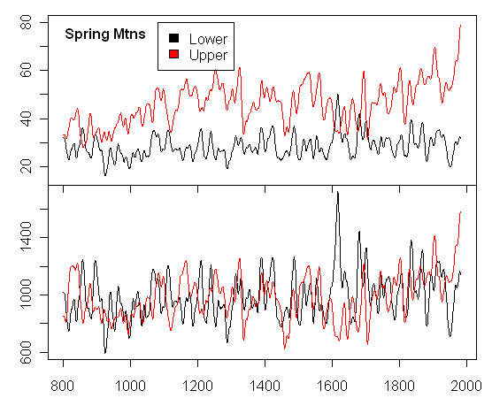
Figure 1. Spring Mountains NV. Top panel – Mean ring width for upper site (Spring Mt Upper 3420 m) and lower site (Spring Mt Lower 3000 m); bottom panel – archived chronologies (age-adjusted) for Charleston Peak (upper) and Spring Mt Lower
Secondly, I show the same information for the White Mountains CA, where the same phenomenon occurs – wider ring widths at 3400/3475 m as compared to 2805 m. These are the most famous bristlecone sites: Sheep Mountain and Campito Mountain are the upper sites (these are well-known to readers of this site as the most highly weighted proxies in the MBH North American PC1 and the most influential proxies in the NH temperature reconstruction). The lower site is Methuselah Walk, a famous bristlecone site. The top panel of Figure 2 below shows the simple mean ring width (without age adjustment) by year. The correlation between the two series is 0.38. The bottom panel shows the archived chronologies for Methuselah Walk and Sheep Mountain. The age-adjustment here, as elsewhere, has the effect here of decreasing MWP levels relative to modern levels. But once again, in the simplest terms, the higher cooler site has wider ring widths.

Figure 2. White Mountains CA Top panel – Mean ring width for upper sites (Sheep Mt 3475m; Campito Mt 3400 m) and lower site (Methuselah Walk 2805 m); bottom panel – archived chronology (age-adjusted) for Sheep Mt and Methuselah Walk. Horisontal scale is from 0 to 2000.
The third Hughes and Funkhouser [2003] site is Pearl Peak NV. The same phenomenon occurs once again. The higher site (3170 m this time) has wider widths than the lower site (2810 m). The correlation here (0.51) is quite high.
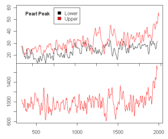
Figure 3. Pearl Peak NV. Top panel – Mean ring width for upper site (Pearl Peak Upper 3170 m) and lower site (Pearl Peak Lower 2810 m); bottom panel – archived chronology (age-adjusted) for Pearl Peak Upper. Horizontal scale is inconsistent between panels. It is correct for lower panel; upper panel goes from 700 to 2000.
Finally, here is the comparable information from Timber Gap CA, a foxtail pine site, previously discussed with pictures here . This has the least difference between upper (3216 m) and lower (3017 m) sites. The correlation is 0.49. The effects of age-adjustment on the chronologies is quite marked here in affecting the relative MWP and modern levels. (Given the potency of the issue of MWP and modern levels, it is remarkable how much hangs on nuances of age adjustment methods.) A very striking aspect of the top panel is the reversal of levels between lower and upper sites around 1900. What accounts for this? You’d think that such an interesting phenomenon would have provoked some commentary in the literature prior to using the series as key temperature proxies.
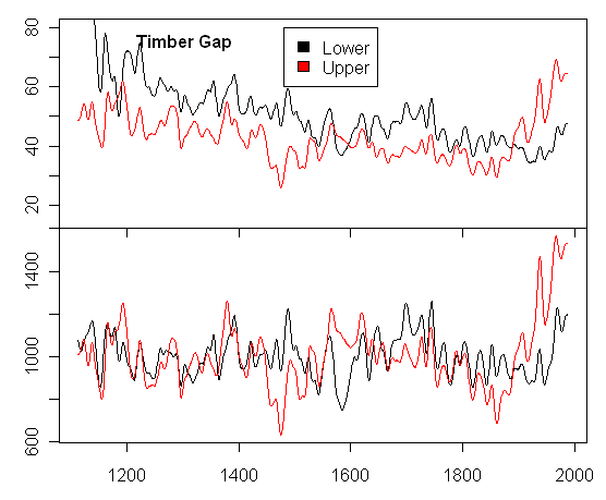
Figure 4. Timber Gap CA. Top panel – Mean ring width for upper site (Timber Gap Upper 3216 m) and lower site (Timber Gap Lower 3017 m); bottom panel – archived chronologies (age-adjusted) for Timber Gap Upper (upper) and Timber Gap Lower.
In the past, I’ve pointed out many problematic aspects to bristlecones as a temperature proxy – see especially our E&E article. The CO2 fertilization hypothesis of Graybill and Idso is an important consideration, but we did not limit ourselves to this particular hypothesis. Among other points, we observed that, since bristlecone is competing with sagebrush, it is obviously stressed by precipitation, a point which is made in the specialist literature. – let alone THE critical proxy in NH temperature reconstruction. In any event, there are obviously some complicated gradients affecting bristlecone growth and the sites do NOT display the simple temperature gradient that is essential to a good temperature proxy. Problems with these proxies have an impact on MBH, Crowley and Lowery [2000], Esper et al [2002] and Moberg et al [2005].


18 Comments
A VERY interesting post indeed that demands a response from the Hockey Team. Surely they would have analysed the data to the extent you have, and seen the anomalous outcomes? This data seems to effectively debunk the use of Bristlecone pines as a proxy for temperature at all.
It will be an interesting test to see if the Hockey Team is a) aware of the data, the analysis, b) has explored what the data means for the use of Bristlecone tree ring widths as a proxy for temperature c) can come up with a clear and cogent explanation (backed up by data and competent analysis)why Steve’s analysis of the data is in some way mistaken.
The inevitable conclusion from this data is that Bristlecone pines are demonstrably NOT a reliable proxy for temperature, unless of course there are (previously unrecognised?) reasons why higher elevations had higher temperatures for much of the past millenium.
A point of clarification. As a layman, I find the upper graphic in each case to be very clear, at least in the information that it presents, but I struggled to understand what the “archived chronology” graph in the lower panel is showing. If I look at the Y-axis, I see values that appear to be years, and if I look at the X-axis, I am looking at years as well. Perhaps you might explain what the lower graph in each case is showing?
Keep up the good work.
I think it’s supposed to be age of trees. So years would also be the proper unit.
How do the deltas at a location compare with solar sunspot history? It has been projected back before Galileo.
Steve, yet another fine bit of work. Could you get dates on the bottom of all the graphs?
Re: #1,2
The lower panel in each shows relative growth by year, but because of the “age-adjustment” process used in the papers, the resulting number does not have an actual unit like the mm used in the upper panels.
1. The results and the method of analysis are interesting. It should be published.
2. This is not a coup de grace as the first poster thinks…and Steve would do well when he publishes to think not solely in terms of “how this conflicts with MBH”, but instead put forth his information as showing that things are more complicated than we think. (suggesting that the field needs to look at this issue to advance.)
3. I’m curious exactly what the stickers mean when they say something is precip limited. I can see how this would give different yearly behavior versus temp, but now how low altitudes would have smaller rings.
4. How do you sqaure these results with the earlier altitude paper that you reviewed? didn’t it have expected RW versus altitude behavior?
#5. 4. I don’t have any data from Naurzbaev, but based on their reports, the conifers that they studied showed RW-altitude behavior. The Russian conifers were nearly all much further north and I presume relatively moist. Many bristlecones are in very arid environments; they compete with sagebrush. In our E&E article, we noted an early article pointing out that you could see a geological contact between limestone and sandstone from the bristlecones on one side and sagebrush on the other with the contact going up the hill. The bristlecones stop growing when the soil moisture falls below a certain level. My guess is that even the upper site bristlecones, said to be “temperature limited”, are influenced by precipitation – Willis alluded to this type of effect from his youth. I can’t figure out what would cause the crossing at Timber Gap – that seems pretty weird to me. One of the many things that frustrates me about these guys is their lack of inquisitiveness about the data – they are all so busy trying to connect their little data sets to global warming .
yeah…I agree. That’s why when YOU write this up, you should avoid the same tendancy. The tendancy to think only in terms of how it affects the war with Mann versus just finding interesting things. Like your grass curves, they should be published purely as an example to the field of something they should start doing to help them look at data.
I agree with TCO that this needs to be published. It is interesting because it shows that tree rings widths are effected by more than one variable.
Re: #6.
A working hypothesis would be temperature. To my eye the upper and lower series could be negatively related. This is esp visibile in Pearl Peak data, when one goes up the other goes down. This is to be expected from the physiology if the upper and lower are on different sides of the inverted ‘U’ curve. Judged against this model 20th century behaviour seems anomolous.
Re #6: In all of the sites, the ring width graph for the lower site has run either level or slightly downhill from left to right.
In all of the sites, the graph of the upper site shows anomalous growth in the last century.
The “crossing at Timber Gap” is an artefact. Of the sites shown, only at Timber Gap does the lower site (as expected) have wider ring width than the upper site. However, during the anomalous upper site growth of the last century, they reverse positions.
The question you pose, as I understand it, is how can we possibly uutilize sites where upper site ring width is greater than lower site ring width as a temperature proxy? This is a critical question. One hopes they might discuss this stuff.
w.
Another interesting point about this: consider Timber Gap again. The elevation difference between upper and lower sites is only 200 m. A typical lapse rate is say 0.6 deg C / 100 m. But the upper ring widths are historically almost twice as large as the lower site – there is a "large" difference of 0.2 mm (the upper panel units are 0.01 mm – I should have noted this). Wouldn’t interdecadal temperature variations be just as large as this lapse rate? I’ll plot up and post annual series without being smoothed). In any event, the difference in ring widths over 200 m of altitude is a lot.
This ties into an interesting bias in nearly all tree ring width series. You may recall prior discussion of sampling bias – tree ringers do not sample small trees. Melvin, a student of Briffa’s, mentioned 5 mm diameter as a typical minimum. In the 20th century, tree lines have been rising but sampling has not (due to minimum sample girth). We’re seeing very big differences in ring width over rather short elevation intervals. So the absence of samples from the higher elevations has to bias the sample somehow. Note again that medieval treelines were typically higher than modern treelines and these higher trees were sampled in the medieval period. (discussed in connection with Polar Urals – see Category right frame)
There could be lots of reasons for this Steve. The competition you mentioned with Sagebrush, with other trees of the same species reducing growth. You could say the ‘prefer’ the higher altitudes but this is a bit anthropomorphic. Comparing annual temperature and lapse rate could be misleading too, as differences could be greater in the important growth season. Cloud effects adding mist. Many things.
Sorry, I started typing two responses now, but I made the mistake of leaving the page during composition and returned to find my post gone…this will be abbreviated therefore, and I’ll clarify if requested.
Re: #11:
Unless you are using a lapse rate with which I am not familiar, I think you need to either drop a zero from the height (so it says .6 deg C/100 m), or move the decimal to the right for temperature (so it says 6 deg C /1000 m).
And could you clarify the lapse rate to which you were referring? We usually discuss three. The first two are associated with the expansion air as it ascends:
Dry Adiabatic Lapse Rate (for unsaturated air–relative humidity less than 100%): about 10 deg c/ 1000 m
Wet Adiabatic Lapse Rate (for saturated air–RH = 100%): about 6 deg c/ 1000 m; greater at cold temps, less at warm temps
The other rate is the observed, or “environmental” lapse rate. On average it is 6.5 deg C / 1000 m, though it is rarely exactly this value through any given layer of the atmosphere or for a prolonged period. Obviously with inversions, this lapse rate would be negative, because the temperature increases with height.
As related to normal environmental and adiabatic processes, you would expect the upper site to be 1 to 1.5 deg C cooler than the lower site. You would also expect the upper site to be slightly more moist, unless the lower site was windward and the higher site leeward.
Anyway, I would appreciate a clarification so I can better follow your argument.
Thanks.
sorry about that typo. I meant 0.6 deg C/100 m. I edited the post.
Climatic stations White Mountains 1 and White Mountains 2 operated from ~1950 to 1980. WM1 at 10150′ (3100 m) and WM2 at 12470′ (3800 m). WM1 had mean annual temperature of +2.3 deg C and 31 cm precipitation; WM2 had average temperature of -2.4 deg C and precipitation of 36.5 cm. Obviously cold and dry. Local gradients (up) would be therefore about -0.67 deg C/100 m and +0.8 cm/100 m, although I’m sure that this varies a lot in the different microclimates.
The key control on growth seems to be soil moisture, which remains above critical levels for longer at higher altitudes. I’ve got a post in the works on this.
So, not only do we see that some of the 20th century Bristlecone growth-patterns are anomalous generally among trees, but even in comparison w/very nearby (just lower on same mountain) Bristlecones!
The possible reasons for these differences could be endless, w/higher temps = greater growth not apparently among them.
More White Mountain climate notes based on local knowledge.
During the period Oct – April inversions are common between winter storms. Winter storms coming in from the West or SW produce minimal precip with somewhat higher snow level and lots of wind and mix out the inversion. Storms coming down from the north (and even the odd retrograde cut off low coming in from the northeast or east) have less wind and produce more precip due to the fact they don’t have the cross the Sierra Nevada (and incur the rainshadow). Years where the northerly Siberian Express sets up (classic examples, last year and the year before) tend to keep the snow cover on the ground longer (both between the storms and overall) and the snow pack can last until June or July. Mammoth Mtn Ski Area (not in the Whites, but nearby, on the East slope of the Sierra) can be open on the 4th of July more often than not. Years where the Siberian Express does not set up result in an earlier melt off and if there is not an El Nino, a deficient snow pack. A highly unusual climate with large variations in temps and precip on all time scales.
Check out the Reno NWS site every few days for a year and you’ll get a sense of how the climate in the Whites works.
Was more here than I remembered. Needs to be published. Try not to get too wrapped up into your combat with Mann or to say that you understand the whole story. (the result is interesting independant of MBH and you DON’T understand the whole story.) Nevertheless, you’ve done an analysis that shows something interesting. That is sufficent to publish.
Steve: BUMP on publishing this. Why don’t you coauthor with one of the “young dendros” you met & liked at AGU? Killing 2 birds with one stone — bird #2 being your obvious distaste for the mechanics of academic publishing. Which, you can point out to your prospective collaborator, will be valuable experience for them 😉
Just DO it. Dendroclimatology NEEDS you!
Cheers — Pete Tillman
—
“Gentlemen, you can’t fight in here — this is the War Room.”
— Dr. Strangelove (Stanley Kubrick)