I’ve been working through Jones and Mann [2004] and Mann and Jones [2003] and the following graphic caught my eye. I quickly compare it here to the version used in Jones et al. [1998] and the Mann and Jones [2003] SH reconstruction (shown in Jones and Mann [2004]).

Figure 1. Replication of Figure 4 (bottom panel) of Jones and Mann [2004], which is standardized to 1750-1960 and smoothed.
The above Lawdome version presumably supercedes the older version used in Jones et al. [1998], shown below.

Figure 2. Lawdome, plotted from data used in Jones et al. [1998]. This was also standardized to 1750-1950.
Finally, here is the SH temperature reconstruction shown in Figure 5 of Jones and Mann [2004], showing calculations from Mann and Jones [2003]. It’s hard to see that the Lawdome data has much influence in this graphic. This calculation looks worth examining.
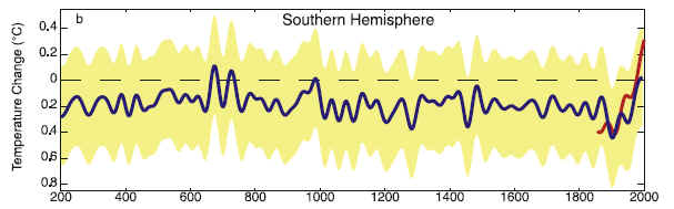
Figure 3. SH reconstruction for Figure 5 of Jones and Mann [2004].


One Comment
John daley did an article on the 1991 Cook Huon pine series from Tasmania, focusing on the local temperatures used to “calibrate” the tree rings. See http://www.john-daly.com/huonpine.htm. His basic complaint is that Cook compared the tree rings to three local temperature series, Launceston, Hobart, and Low Head. All three of these are problematical, Launceston and Hobart have a probably significant but uncorrected UHI, and Low Head has an uncorrected instrumental error that John exposed. The Low Head temperature site has become screened by trees from the prevailing winds over the past decades, andf as a result shows a marked daytime temperature increase. There are many rural stations with that could have been used instead. A further complaint of JD’s was that the trees are on the West side of Tasmania, and all three of the temeprature sites on the East, and Tasmania has a marked East/West climate variation, for example mean annual precipitation is 445 mm on the East, and 3546 mm in the West. Worth further investigation perhaps.