Last Friday, Science sent me measurement data used at 10 Esper sites — thanks to Science for this. Measurement data for 4 important sites (the Boreal and Upperwright foxtail sites; Polar Urals and Mongolia) were not sent. Hanson of Science commented that the Polar Urals site and some of the sites that he checked were at ITRDB.
Esper et al [2002] did not provide data citations to ITRDB data sets (nor did Hanson). Working backwards from the measurement data now provided by Esper, it turns out that, for a number of sites, one can locate combinations of ITRDB sites that constitute the Esper sets. However, I was certainly unable to do so without consulting the Esper data and I’ll show through an example the nature ofd the obstacles to guessing how to combine candidate data sets.
The identification information available in Esper et al [20002] is a very minute map showing a site denoted “Mackenzie” located in far northwest Canada near the coast of the Arctic Ocean. In footnote 25, they acknowledge “J. Szeicz (Mackenzie)” as being one of the persons who “sampled the tree-ring data sets in 14 different regions of the Northern Hemisphere and/or made them available to do this study”. They cite Szeicz and MacDonald [1997] (reference 17) as one of a number of studies relied on for this study as follows:
Several of the tree-ring collections analyzed here have been described and used previously in individual and large-scale temperature reconstructions and related studies (11, 13–19). Ring widths of trees growing in cold environments usually reflect the influence of warm-season temperatures on growth most strongly. However, in some cases, they also reflect temperatures from the cool-season months before the radial growth season as well (20). Here, we will not explicitly model the temperature signals of the individual tree-ring chronologies, because this has mostly been done already (11, 13–19).
When I consulted the ITRDB data set at WDCP on a previous occasion, I found that Szeicz, MacDonald and Lundberg had contributed series cana138, which is located at 6816N-13320W more or less where the dot on the map is located and which was said to be in the Northwest Territories. Based on all of this, I had concluded that the Szeicz data had something to do with the data used in Esper et al. [2002]. This might still be the case, but the data set supplied by Science on March 16, 2002 for this site (“cam.rwl”) does not appear to contain any data from the data set cana138.rwl. (For reference, Figure 1 shows my calculation of the RCS chronology on the Szeicz data set, showing declining values after the 1930s.
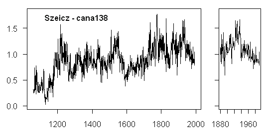
Figure 1. RCS chronology (my calculation) for Szeicz data set cana138
When I obtained the Esper data set cam.rwl, I first noticed that it contained 58 cores, as compared with 93 cores in the Szeicz data set. Secondly, while I found that core identification numbers in correctly identified sites (e.g. Gotland) match core identification numbers in the corresponding ITRDB data sets (swed022w), this was not the case for the Szeicz data, which did not match at all.
Now the form of identification number in the Esper data set had the form of Schweingruber identifications (and we’d already seen a precedent where a site attibuted in Esper et al to Filion and Payette (Quebec) was actually a Schweingruber site (cana169w), so I checked to see if there were Schweingruber sites in the same area. There were no corresponding sites in the Northwest Territories. On a chance, I also checked the Yukon and it turned out that there were two Schweingruber sites located in the Yukon which had the same lat-long as the Szeicz site in the Northwest Territories (!?!). (The Yukon-NWT border at this latitude is at 136W see here.
The form of identification in these two Schweingruber sites (cana172w, cana173w) in the ITRDB data set was similar to the Esper data set, but did not match exactly. The digits "117" and "118" were in common between the two forms, but the Esper identification codes were 8 digits long, while the ITRDB codes were 6 digits long. In addition, there were 58 cores in the Esper file, but only 28 in the two Schweingruber files. Curiously, if one extracted the middle 6 digits from the 58 Schweingruber codes, one obtained 28 unique values, which matched exactly to the 28 codes in the combined ITRDB data.
Next step, it turns out that the Schweingruber data is stored at WDCP in two locations – one in ITRDB format and one in “Birminsdorf format” which is the more authoritative version. In the Birminsdorf data set, I located candidates for the two Schweingruber sites under the identification codes "cadopcg" and "cadorpcg". In this case, the identification codes match exactly to the Esper collation and the total number of cores between the two sites in the Birminsdorf directory amounts to 58 ( 36 and 22 respectively).
So yes, one can locate the data used by Esper et al. [2002] for the Mackenzie Mountains at WDCP as a combination of the cadopcg and cadorpcg data sets in the Birminsdorf directory. I have no idea how one would have been able to figure this out without access to the specific data set used by Esper et al 2002. It was tricky figuring this out even with the data.
For what it’s worth, Figure 2 below shows my emulation of the RCS chronology using the Esper et al data set.
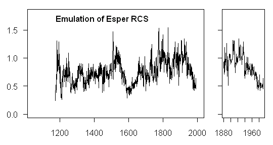
Figure 2. RCS chronology (my calculation) for Esper et al data set cam.rwl (=cadopcg+cadorpcg)
It has a very high correlation (0.85) to the corresponding series for the Szeicz data, so I’m wondering whether there might be some overlap in the data after all. I haven’t checked individual cores to test overlap.
Finally, Figure 3 shows the version of the RCS series used in Esper et al. as sent to me by Science in Feb 2006.

Figure 3. Archived RCS chronology for Esper et al cam.rwl (available in Feb 2006)
It has a very high correlation to my RCS emulation (0.965), but the average values are lower. The mean for the archived RCS series is 0.58, which is about 25% less than the average value of 0.76 in my emulation. I checked the averages of all the archived RCS versions and they varied substantially between sites with a range of almost 100%. I don’t know why – perhaps some weighting factor has been incorporated into what was sent to me.
The downward values of ring widths in the Yukon in late 20th century have been noticed before (the Divergence Problem). Here’s another example. This Esper site is not incorporated into the Osborna and Briffa [2006] set of 14 series, presumably on the basis that the ring width chronology does not correlate to temperature – raising the question as to why some spruce sites correlate to temperature and some don’t.


10 Comments
Steve,
Congratulations on the detective work but why for pity’s sake won’t these people give proper and accurate citations? Is it a fetish?
Because they’ve been paid by Big Oil not to?
I’ve heard the “divergence” problem is due to temperatures actually nearing the “hump” in the curve for temperature vs. ring width. However, I’d be willing to bet there are other issues, such as humidty, cloud cover, soil moisture, CO2 content in the air (that is plant food, right?), etc. I.e. they – tree-ring advocates – are not taking into consideration any of these other factors when choosing series to use. Unfortunately, by doing so, they can contaminate their own data by picking series that may actually correlate in short bursts when all other factors are not interfering with the results. Hit a dry spell or some other period where the weather (not climate) changes significantly and suddenly the rings no longer correlate. In short, they need to account for such variables for the sake of their own argument, let alone Steve’s and Ross’.
Another thing I’m curious about, Steve, do the correlations occur against [i]local[/i] temperature records or global means? I think it may be MUCH more accurate to correlate against unfiltered local records because, well, quite simply, the temperature in China in 1865 doesn’t have much impact on a tree in NA in 1885, let alone 1865. By doing a “smoothed” average, the energy from each year is essentially spread out over the length of the filter, and impacts any correlation function that is performed.
This could also explain poor r2 statistics as local and global temperature records do not jive in the least.
Mark
It seems to me that stand density, alone, could account for “divergence.” It would be interesting to evaluate the effects stand density, if the data were available (which it probably isn’t). Assume average yearly air temperature IS a major factor controlling growth. Then, those spruce trees which have access to full sunlight (that is, those that are “in the open”) would be above the minimum temperature required for growth longer each day than those not in complete sunlight (since leaf temperatures in sunlight are higher than those in shade at a given temperature). And they would be at or above this minimum temperature longer each day if average air temperatures are increasing. Other factors being equal, they might show increasing growth rate with increasing average air temperature. Now, consider a poor little spruce that is being gradually shaded more and more by it’s neighbors. The effects of increasing average yearly air temperature could easily be more than offset by the shading effects as all the trees in the stand continue to grow. Lack of adequate moisture or poor soils could also greatly retard growth for trees that are spaced closely, more than offseting any effects of raising temperatures. Adjustments for tree age would not correct for these effects.
Do any of these dendro studies provide a good description of the site? A great deal more information is needed before tree rings can serve as proxies without cherry-picking, IMO.
3:
I’ve provided linkies on this site before on how stands are cored. Your concerns are assuming that stand density is even and openings don’t happen, in addition to not considering the way samples are taken, all of which is incorrect.
Best,
D
Dano: ??
A filter doesn’t spread it out, it removes it.
#3, 4. I’m inclined to agree with Dano here. While the ecological description of tree ring sites is abysmal and there are no requirements for dendro people to archive any such information, in cases where I’ve seen site photographs, the stands in these series are usually pretty open.
Re #3
In addition to stand density, how about position within the stand relative to the prevailing wind? And then there’s “amount of wind”, where trees grow most effectively where the relative humidity is as high as possible, so as to reduce evaporation in the leaf stomata.
Steve,
In the sentence:
“Curiously, if one extracted the middle 6 digits from the 58 Schweingruber codes, one obtained 28 unique values, which matched exactly to the 28 codes in the combined ITRDB data.”
“58 Schweingruber” seems incongruous. Should it be “58 Esper” ?
These also show the ~1540 “spike” & subsequent cooling, & another at ~1940. So there are some common, synchronized blips showing up in alot of tree-ring studies. What those signals are caused by is the question.
Global, synched “blips” going in the same direction seem to defy the MWP/LIA “local” arguments, and to initially evolve from a widespread, instantaneous forcing — um, like solar.
CO2 doesn’t look to be having much effect at all, greenhouse or otherwise. Relevant for a subarctic site — supposedly the first areas affected by AGW. IIRC, the properly-analyzed Russian Urals results show something similar to this study.