Naurzbaev et al [2004] is a terrific article by Naurzbaev, Hughes (yes, that Hughes) and Vaganov about deducing climate information from tree-ring growth curves in Siberia. (I find Naurzbaev’s work consistently interesting.) They studied 34 larch sites in a meridional transect from 55 to 72 N (at a longitude of about 90-100E) and 23 larch sites along an altitudinal transect from 1120 to 2350 m around Tuva (~ 51N, 95E). So they’ve already started off with a consistent population – not some grab-bag like MBH98 or cherry-picking like Jacoby. The transect includes the Taimyr peninsula, chronologies from which occur in Esper et al [2002] and Mann et al [EOS 2003].
Their abstract (which I’ll quote below) gives no clue as to the interesting facts in the article. At each site, they fit a negative exponential age curve to ring width RW of the form:
RW ~ Imin + I0* exp (-C* age)
and then keep track of the Regional Growth Curve (RGC) parameters I0, Imin and the the average ring width for trees 50-100 years old (I50_100) across the transects. Sounds sensible already.
In the latitudinal transect, they found strong negative correlations of all three parameters with latitude (r =-0.74, -0.67 and -0.77) and high positive correlations with mean annual and mean summer temperatures, which they interpret as showing a systematic gradient in RGC parameters along the transect. (They also found a strong positive correlation to precipitation in the northern part of the transect (64-72N) and a negative correlation in the southern part (52-64N). They note a weak negative correlation between maximum age and average growth – along the lines of the point originally made by Schulman [1954] that slowly growing trees achieve greater longevity than fast growing trees.
In the altitudinal transect, they found found a gradient in the growth curve with elevation that was nearly twice as strong per unit temperature change, observing that I 50_100 changes by 0.09 mm/deg C on the elevational transect and only 0.05 mm/deg C on the meridional transect. This is not discussed unfortunately.
They used these relationships to estimate past conditions for subfossil trees, nicely quantifying for a few interesting cases the seemingly obvious point that treeline changes reflect past climate. But here they do much better than that point: they’ve studied and quantified the past growth and placed in a modern context using the information from their transects. I’ve excerpted their Table 2 below, which summarizes the major points.
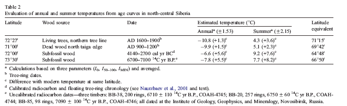
They comment about the site in the second line of the table as follows:
Trees that lived at the upper (elevational) tree limit during the so-called Medieval Warm Epoch (from A.D. 900 to 1200) show annual and summer temperature warmer by 1.5 and 2.3 deg C, respectively, approximately one standard deviation of modern temperature. Note that these trees grew 150-200 m higher (1-1.2 deg C cooler) than those at low elevation but the same latitude, implying that this may be an underestimate of the actual temperature difference.
Their summary is very odd here – surely it’s more reasonable to allow for the altitude effect: this would yield an estimate that the MWP annual temperature was 2.58-2.86 deg C warmer than at present and the summer MWP temperature was 3.38-3.66 deg C warmer than at present. There’s nothing here that’s inconsistent with Shiyatov’s observations about the Polar Urals, which I’ve mentioned before. The third line shows a subfossil site at 72N that was dated to ~ 4140-2700 BC (6140-4700 BP), before the climatic decline of the late 3rd millennium BC. Here they report:
The RGC corresponds to a mean annual temperature of -6.6 deg C and a mean May-September temperature of 9.2 deg C, and also to modern conditions at approximately 65N. The estimated latitudinal difference is about 7N. This implies that at the time these trees grew, growth conditions in this area were equal to those in the modern north taiga region. Average differences between modern and ancient annual temperature were estimated as 6.7 deg C (minimum difference is about 2.3 deg C if the standard deviation is taken into account), with the same magnitude of difference for May”€œSeptember temperature.
The key comparison numbers are the difference between the latitude in column 1 and the latitude equivalent on column 6. The fourth site (line 4) has similar results and a latitudinal difference of 6 deg 40′ is estimated. They conclude:
the Holocene Climatic Optimum on the Taimyr Peninsula, the northern tree line was located about 450 km (minimally 250 km) further north than at present….
This is consistent with other observations on ancient tree lines in northern Eurasia, some parts of North America and the north of Scandinavia (Huntley and Prentice, 1988; Kullman and Kjallgren, 2000; MacDonald et al., 1993, 2000). For example, Kullman and Kjallgren (2000) reported that the greatest elevational extension of forest in Scandinavian mountains at the beginning of the Holocene was about 500 m above the modern upper tree line, which means temperatures were warmer by at least 3 deg C (assuming 0.6 deg C temperature decrease for every 100 m increase in elevation). There are several other regions in Northern Eurasia and northern North America where RGC parameters may be subject to relatively simple control by temperature, and where abundant relict wood exists covering several periods in the Holocene. Thus, the possibility exists of adding a new kind of record for such times and regions, even if it is not possible to develop well-replicated tree-ring chronologies known to conserve century-scale climate information for the whole period.
With all this interesting information, you’d think that they’d have a dynamite abstract. Unfortunately, their abstract gives little clue as to these striking findings:
Regional growth curves (RGCs) have been recently used to provide a new basis for removing nonclimatic trend from tree-ring data. Here we propose a different use for RGCs and explore their properties along two transects, one meridional and the other elevational. RGCs consisting of mean ring width plotted against cambial age were developed for larch samples from 34 sites along a meridional transect (55″€œ72 degN) in central Siberia, and for 24 sites on an elevational gradient (1120 and 2350 m a.s.l.) in Tuva and neighboring Mongolia at approximately 51 deg N. There are systematic gradients of the parameters of the RGCs, such as I0-maximum tree-ring width near pith, and Imin, the asymptotic value of tree-ring width in old trees. They are smaller at higher latitude and elevation. Annual mean temperature and mean May”€œSeptember temperature are highly correlated with latitude here, and hence RGC parameters are correlated with these climatic variables. Correlations with precipitation are more complex, and contradictory between meridional and elevational transects. The presence of a similar gradient in the elevational transect is consistent with temperature being the causal factor for both gradients, rather than, for example, latitude dependent patterns of seasonal photoperiod change. Taking ring measurements from collections of relict and subfossil wood, the RGC”€œlatitude and RGC”€œtemperature relationships are used to estimate paleo-temperatures on centennial time scales. These estimates are consistent with earlier btraditionalQ dendroclimatic approaches, and with independent information on the northern extent of forest growth in the early mid-Holocene. It may be possible to use this same approach to make estimates of century-scale paleo-temperatures in other regions where abundant relict wood is present.
Reference:
Mukhtar M. Naurzbaev, Malcolm K. Hughes, Eugene A. Vaganov, 2004. Tree-ring growth curves as sources of climatic information, Quaternary Research 62, 126″€œ 133


26 Comments
“For example, Kullman and Kjallgren (2000) reported that the greatest elevational extension of forest in Scandinavian mountains at the beginning of the Holocene was about 500 m above the modern upper tree line, which means temperatures were warmer by at least 38C”
is 38C correct or should it be 3.8C?
Masterpiece of understatement Steve. I suppose now Naomi Oreskes will place this paper in the category of implicitly accepting the consensus view.
Re #1 – the pdf text excerpt reader interpreted the degree “o” as an 8. I picked up most of them, but lost these ones. Fixed.
Re #2 – it would be amusing to see how Naomi Oreskes classified this one. Did she ever release her classification?
http://www.climateaudit.org/wp-images/naurzb8.gif doesn’t display in my browser
Nor mine
It’s very much the norm in this field for things that make GW look bad (even isolated observations, studies) to avoid drawing a wider conclusion, to downplay the find, or to say “but of course we believe in GW, this is not sufficient to hurt that thesis”*. For things that make GW look like a good theory, they trumpet it.
Note, that I actually think GW is happenening at a Bayesian level of 3-1 betting. (Over last century. Have no even Bayesian** feel for if it will accelerate or self-limit, though.)
*The last a non sequiter.
**sounds cool, eh?
Re: #3. All I have seen was in the paper: explicit endorsement of the consensus position, evaluation of impacts, mitigation proposals, methods, paleoclimate analysis, and rejection of the consensus position. I suppose it would have been put into paleoclimate analysis, so perhaps my immediate response was half-baked. Apparently paleoclimate analysis has nothing to say about AGW (sarcasm). But I am truly concerned by papers projected as methodological when they have significant contrarian findings. I can guess at why, but like Crichton, won’t attribute motivation.
Regarding the general problem of getting researchers in a field to consider opinions that do not mesh with their preconceptions, some great quotes from a “Wired” interview with Thomas Gold (“The Deep Hot Biosphere”):
Q. You clearly don’t have a very high opinion of geologists.
A.That is true. They’re so enormously fashion-conscious. It was very unfashionable to think that the continents had moved. And then from one year to the next it was declared that it was all right, that the continents had moved. And then if you had any difficulty with the details of how the continents had moved, you were a crackpot. They just follow a leader…
But the pulsar episode shaped my attitude more than anything else. My idea that rotating neutron stars were responsible for pulsars was totally ridiculed at an international conference. I was not allowed to speak from the podium for five minutes in a two-day conference because it was regarded as such a monstrous idea. That was in the spring, and I think by November or December of that year, observations of the pulsar in the Crab Nebula had confirmed every damn thing that I’d said – confirmed that the frequencies of a young pulsar would be higher, confirmed that good places to look would be supernova remnants, and a number of other things.
After that, I was never going to compromise with other people’s opinions again: Just know the facts.
[as Glenn says, read the whole thing]
http://www.wired.com/wired/archive/8.07/gold_pr.html
1. how is dead wood different from subfossil?
2. Why dating in BC and BP?
3. What is the taiga edge? how related to other edge?
4. There appears to be a mistake in the post where one of the quotes has your comment mixed into the offset qouted part.
5. I don’t quite get the implication vis a vis RGC. They say that not only can RGCs be used to correct for age effect, but for something else? It’s unclear to me what that big finding or difference in method is.
TCO, I think the “something else” is that RGCs are a reproducible, standardized growth pattern that can allow you to make comparisons between different tree populations. Thus they can be used to calculate average growing condition (here mostly temperature) differences between different areas. So, if you’ve worked out that growing at 100m higher altitude is equivalent to growing (for example) at 1C colder temp, and you see that trees 1000 years ago grew at 100m higher altitudes than now at the same latitude, you can infer that 1000 years ago average temps were 1C hotter than now.
This is a proper “working your way up from the biology” study of a climate proxy, not a “toss in a lot of number series and see if anything interesting-looking comes out the other end” type of study.
But I always thought that the purpose of the RGC was to deconvolute age of tree effects to allow other comparisons to be made. It seems like that is what is being done. What was supposed to be done. Not sure how this is some big “other use”.
OK, I think I’ve got it now. You’re right, the traditional use of RGCs is to normalize the ring widths so they could be studied; the parameters of the various RGCs were not studied further. In this paper, instead of studying the ring widths, they study the *parameters* of the RGCs they construct from various meridional or altitudinal transects. The construction of each RGC distills the growth conditions of a group of trees clustered in time (decades to a few hundred years?) and space into a few parameter values. Some of these parameters seem to have good correlations with climate variables of interest — pretty neat!
In a way, the technique is even lower brow than curve parameters. One of the statistics is: the average ring width of trees from 50-100 years old. This cuts out juvenile effects and oddities of very old trees. One of the advantages of the Naurzbaev transect is that the information was presumably collected on a consistent basis – so you don’t have the difficulties of trying to decode old records which didn’t report altitude, didn’t control for pith offset, etc. etc.
If the older dendro studies didn’t keep information on the altitude of each tree and there are changes over time, then I don’t say how you can extract usable information about long-term climate change from them.
I’ve been mentioning various sites in the western U.S. where there’s subfossil wood. Why wouldn’t someone do transects and get some nice clean results similar to Naurzbaev?
Sounds like fun! Road trip & working vacation in one! Maybe enough of the readers here would be willing to undergo core-sampling/collection training to set up an expedition? I’m sure TCO has the energy to collect at least 1000 cores/day!
Maybe we could get some industry funding….or maybe not.
Steve
Re # “In the altitudinal transect, they found found a gradient in the growth curve with elevation that was nearly twice as strong per unit temperature change, observing that I 50_100 changes by 0.09 mm/deg C on the elevational transect and only 0.05 mm/deg C on the meridional transect. This is not discussed unfortunately.”
Isn’t that the effect of seasonality (light for longer in summer at higher latitudes), which they mention at the beginning of the paragraph?
TCO and others, some quick comments re various above.
1. BC means Before Christ, or in terms of the present Western calander system, 0 AD,
2. BP means before present, ie this year. An idiot definition since each year the written record needs to be updated. But useful for political purposes.
3. Tommy Gold and fashionable geologists – too true. The problem is geological uniformitarianism, created by Sir Charles Lyell, first and foremost a lawyer and a Whig (predecessor of the social democrats and post-modernists). Lyell and his Whig cohort were after political power in the UK parliament, until then dominated by the Tories, their authority based on Christian scripture. Lyell, as a Methodist and thus as devout as his opponent, The Rev. W. Paley, could not reject Paley’s authority. Instead he transformed the Old Testament into literature, rather than an imperfect record of historical fact. Geology and science has suffered as a result, when fantasy is offered as fact, finally resulting in the present global warming schmozzle.
4. Geologists are keenly concerned with climate, and the climate change debate has not even started.
🙂
Actually BP means before 1950. Its all to do with carbon dating.
And actually I believe the present meaning in the literature of BC is Before Common era and to use CE instead of AD. The dechristianization of terminology is rather silly, IMO as it doesn’t apply to any other religion. At least since the debacle of the French Revolution I don’t believe there’s been a tendency to try replacing the names of the days of the week because of their originally religious origins. [Thursday = Thor’s day; Wednesday = Woden’s day etc.]
I know what they mean. I was commenting on a chart mixing the terms. Pick one or the other was my point.
So does a paper like this make you think that it’s possible to find reasonable proxies, Steve? Is altitude, lattitude, growth correction sufficient to get a proxy with some use?
I’m quite interested in tree line changes, which intuitively can be connected directly to climate. I’ve been collecting information off and on. I don’t see why this wouldn’t be as useful a proxy as (say) coldwater diatom % offshore Oman.
Yeah…you’ve said that before. It may have some use I guess although there would be some issue with time required for forest to move.
Now…how about my question 21 (which I guess is affected by your most recent post…hehe).
Here is a species where altitude does correlate negatively with RW, no?
Regarding comment 14:
Sounds like fun! Road trip & working vacation in one! Maybe enough of the readers here would be willing to undergo core-sampling/collection training to set up an expedition? I’m sure TCO has the energy to collect at least 1000 cores/day!
I live in Southern California. I’ve gone hiking in some very rugged areas (King’s Canyon, triple continental divide, areas around Mammoth Mountain, etc.) and recall seeing many stumps above the current tree lines. I think it would be a blast to get the proper training, grab a high quality GPS & altimeter and go off trail to take some samples at varying altitudes!
I’d want to make sure I did it properly so as not to damage any currently viable trees, etc..
Anyone have any advice on getting the training/tools and desirable target areas? Anyone want a nice set of samples to work with?
Feel free to email me. –>A s h by A t m a c dot c om (wonky spacing to prevent spam)
Ashby
p.s. I’m currently taking some time off work to go paint landscapes, so now would be a good time to do this. 🙂
(I’ll try to submit again. Looks like I may have been spam grabbed.)
One Trackback
[…] and Greenland, but extend to the Sierra Nevadas (117 W), Sweden, Finland, Polar Urals (65 E) and a Siberian transect (90-100E). I’ll add a comment on Chinese proxies of this type. Kultti et al. also consider […]