Jones said that the names of the Australian sites was unknown. However it turned out that the names of these locations are known to mankind and, with a little effort, that the names of these sites could be tracked down from an Australian reference list through the CSIRO reference numbers at the Jones site. My first pass at finding original data for these sites online at CSIRO proved unsuccessful, although the opportunity for purchasing the data from CSIRO is available.
However, an interesting trove of historical information archived here in 1996 turned up. This proved to be the “high quality” network from Torok and Nicholls 1996, that was mentioned in the correspondence between John Daly and Neil Plummer of CSIRO in 1996. That was the letter in which Plummer responded to Daly’s criticism of inhomogeneity at Low Head Lighthouse by saying that Jones et al 1990 made no claim that its stations had been assessed for homogeneity (foolish reader to assume that!) The Maatsuyker lighthouse is mentioned in the Low Head discussion. This post is not just about the Maatsuyker exclusion in the Torok network, but I sort of liked the phrase – it sounds to me like the title of an action novel.
In your report, you query the selection of 49 mostly ‘rural’ stations over eastern Australia as used in Jones et al. 1990. This network was selected on the basis of stations having few missing monthly mean values over the 1930-1988 analysis period. None of the data used had been assessed for homogeneity and the paper makes no claims in this regard. It is interesting to note, however, that the high quality data set of Torok and Nicholls (1996) confirm a warming over this region.
The Torok and Nicholls archive proved to be a substantial collection of data, described in the readme as follows:
A high-quality historical surface air temperature data set, for mean annual temperatures, has been prepared for Australia by adjusting data for inhomogeneities caused by station relocations, changes in exposure and other discontinuities. An objective procedure was developed for determining the necessary adjustments. Station history documentation was also used for this purpose. Time-series of annual mean maximum and mean minimum temperatures have been produced for 224 stations. Trends in annual mean maximum, minimum, the mean of the maximum and minimum, and the range between maximum and minimum, have been calculated at each site. The data set provides adequate spatial coverage of Australia back to 1910 for the production of all-Australia average temperatures. Maximum and minimum temperatures have increased since about 1950, with minimum temperatures increasing faster than the maximum temperatures.
The reference includes a list of stations in Torok and Nicholls classified as rural and urban here . So the first thing to do was to see if the sites in the 49-site Plummer-Jones network are all in the archived Torok and Nicholls network. Wouldn’t it be nice to be able to find all the relevant data, just for once. Take a guess as to how many of the 49 stations in the Plummer list were in the Torok and Nicholls rural list?
29. A further 8 sites from the Plummer rural-village network were in the Torok and Nicholls urban list, listed below (with Newcastle Nobby’s being called urban this time.) One wonders as to how they calculated the average population in the Nature article.
id csiro csiro.name lat long
2 2 18070 PORT LINCOLN -33.73333 135.8667
6 6 23733 MOUNT BARKER -35.06667 138.8667
21 21 40126 MARYBOROUGH -25.53333 152.6000
30 30 56002 ARMIDALE (RADIO STATION 2AD) -30.51667 151.6667
32 32 58037 LISMORE (CENTRE STREET) -28.80000 153.2833
33 33 60026 PORT MACQUARIE (HILL STREET) -31.90000 152.4833
34 34 61055 NEWCASTLE NOBBYS SIGNAL STATION -32.91667 151.8000
35 35 65012 DUBBO (COOREENA RD) -32.21667 148.5667
Twelve sites from the Plummer network did not reappear in the 1996 Torok and Nicholls network, listed below. (Bundaberg airport occurs in the later network)
id csiro csiro.name jones.lat jones.long
1 1 16044 TARCOOLA -30.71667 134.5667
4 4 21043 PORT PIRIE BHAS -33.18333 138.0167
10 10 31016 COOKTOWN POST OFFICE -15.48333 145.2500
13 13 33007 BOWEN POST OFFICE -20.00000 148.1667
14 14 34002 CHARTERS TOWERS POST OFFICE -20.03333 146.3333
15 15 35069 TAMBO POST OFFICE -24.86667 146.2500
18 18 39015 BUNDABERG POST OFFICE -24.83333 152.3500
22 22 41038 GOONDIWINDI POST OFFICE -28.50000 150.2833
23 23 43030 ROMA POST OFFICE -26.53333 148.7667
28 28 51039 NYNGAN AIRPORT -31.56667 147.2000
47 47 94010 CAPE BRUNY LIGHTHOUSE -43.33333 147.0000
48 48 94041 MAATSUYKER ISLAND LIGHTHOUSE -43.66667 146.5000
The net result is illustrated in the graphic below: red is the Torok urban sites in the Plummer-Jones network; blue is the “rural” sites in both networks; cyan is the non-recurring Plummer-Jones sites and small black is additional Torok sites not in the Plummer network.

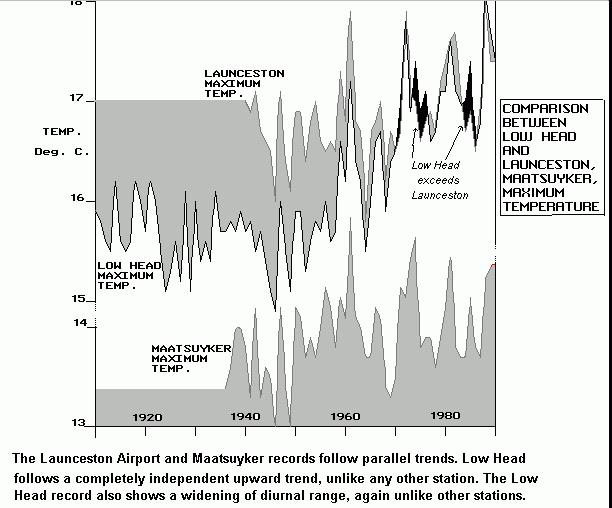
I haven’t made any effort to evaluate these exclusions. However, one of the sites caught my eye because it was mentioned by John Daly in his dissection of the Low Head lighthouse series – Maatsuyker. Daly had observed an anomalous increase in Low Head maximum temperatures. One of his comparanda where there was no trend in maximum temperatures was Maatsuyker in the graphic. I’m sure that there’s a “good” reason for its exclusion, but the Maatsuyker exclusion is just another one of those amazing coincidences that characterize climate science. Oh, in case you were wondering, the Low Head lighthouse site contested by John Daly was included in the Torok and Nicholls network. I guess that I’ll have to compare the Jones 90 version of the Low Head lighthouse with the Torok and Nicholls version tomorrow.
Torok, S. and Nicholls, N., 1996. An historical temperature record for Australia. Aust. Met. Mag. 45, 251-260 is the reference (which I haven’t seen yet.)


19 Comments
I’ve written to BOM as follows:
Warwick Hughes, any comments? 🙂
Please note, temperature observation sites at airfields and airports are selected for the purpose of keeping aircraft from crashing on takeoff and landing by measuring the probable air temperature to be encountered by aircraft using the runways. All other considerations for temperature observation site selection are subordinate to the need for computing an accurate pressure-altitude factor for use by aircrews in setting altimeters and calculating safe aircraft loading ranges. Consequently, the differences in circumstances at each and every airfield and airport results also in a non-uniform and wide range of site selections needed to represent the wide range of conditions presented by grassy runways, asphalt runways, concrete runways, bodies of water producing fog at the ends of runways, and so forth. Therefore, the use of airfield and airport temperature observations as a basis for the extrapolations of climate models accurate to fractions of a degree Celsius appears to be highly speculative at best, untested, and perhaps untestable at worst. Has the use of airfield and airport temperature observations in climate models and extrapolations ever been (1) independently confirmed and validated by scientific experiment (2) in peer reviewed scientific publications (3) with a known and independently confirmed and validated error rate generally accepted by the scientific community without serious dispute? If not, what is the potential effect upon the validity of climate models based in part on such airfield and airport temperatures?
Steve M
Once more you’ve identify more soddy work on the part of the men that make up the ‘consensus’ of scientists who’s warnings we must heed. If John D were still alive today I’m sure he would have something to say on this thread. Yet more cherry-picking on the part of the Wizard of UEA! Oh dear, dear, dear…
KevinUK
#3 Would this then imply that temperature measurements are themselves proxies for advancements in aviation? Oh my?
#3,
My guess, is that if pressed, the Team members will declare that if enough sites are choosen, any errors will average out.
#6
If the observed temperatures at airfields and airports are on average higher than the average temperatures for all other areas of the Earth’s surface and represent a disproportionately higher percentage of the observations, their use will skew the results to give a falsely higher mean surface temperature than actually exists for the Earth’s surface.
In the extreme hypothetical case, adding more airfield and airport temperature observations would have the effect of giving a false impression of ever increasing mean global temperatures where none actually exist.
#4 J Edwards…
“Would this then imply that temperature measurements are themselves proxies for advancements in aviation? Oh my?”
well, certainly a correlation exists between rising temps and advances in aviation…kind of like alcoholism and church of england marriages, or cumulative rainfall and population.
#7, #8
There’s possibly even a causal linkage there. As aircraft grew larger/heavier/more expensive, runways would have to be upgraded to keep pace. Such expansion would contribute to UHI in the vicinity of the airport (i.e. the temperature monitoring station). Thus as aviation has progressed, temperatures around airfields have increased. As Dave B points out, I’m certain a correlation could be shown, and it might perhaps have a better statistical basis than some of the “science” out of the Team.
In recent years, most airports have had to add runways and taxiways to handle increased traffic.
And bigger parking lots to handle extra passengers and more workers.
And of course, many, many airports were originally located well out of town, surrounded by farmland or forest, but their mere presence created an inexorable pull of development, so that they are now heavily urbanized as part of the general metropolitan area.
#7 to #12
Oh ye of little faith! Surely you believe Phil the High Priest of the AGW temple when he says that none of this has any effect (OK 0.05C) on the the highly precise calculations involved in the HADCRUT3 dataset?
KevinUK
Re 2 I am just enjoying watching Steve’s efforts unfold.
In 2000 I put up a page critical of Torok & Nicholls data in a couple of instances.
http://www.warwickhughes.com/climate/bomadj.htm
However it was time consuming and I left it at that.
I am sure there are many more examples to be discovered in T & N of this sort of disconnect with reality.
If one accepts T & N as good work, then some weather records (T) have to be scrapped as wrong.
I was reminded of what Sir Walter Scott said about weaving tangled webs.
Has anyone attempted to determine what proportion of all the temperature data points used in given climate model/s come from observation sites located at airfileds and airports subject to potential UHI effects? How many of these sites were replicated or were used to virtualize grid cell temperatures in locations where no surface temperature observations were made?
The sites that are “rural” in Plummers list and “urban” in T&N:
2 2 18070 PORT LINCOLN -33.73333 135.8667
6 6 23733 MOUNT BARKER -35.06667 138.8667
21 21 40126 MARYBOROUGH -25.53333 152.6000
30 30 56002 ARMIDALE (RADIO STATION 2AD) -30.51667 151.6667
32 32 58037 LISMORE (CENTRE STREET) -28.80000 153.2833
33 33 60026 PORT MACQUARIE (HILL STREET) -31.90000 152.4833
34 34 61055 NEWCASTLE NOBBYS SIGNAL STATION -32.91667 151.8000
35 35 65012 DUBBO (COOREENA RD) -32.21667 148.5667
I’d say all of these are “urban” except Maryborough, of which I have no knowledge.
#7 – #12, Let’s not forget the airplanes. From wikipedia
Today we drove from Marulan (2 hours SW of Sydney) to lower north shore of Sydney. When we set out, the car thermometer said 17 Deg C. At Sydney Airport it reached a peak of 27 Deg C. As we drove alongside the eastern boundary of Sydney City it dropped to 24 Deg C, and when we reached home it was 22 Deg C. Fact.
#1. Received the following reply from BOM Australia”