On an earlier occasion, I observed that one of the key Moberg series (and now an essential Juckes series) was the Arabian Sea percentage G. Bulloides series. At the time, I observed that G. Bulloides was an indicator of cold water. In the Arabian Sea, the surface water offshore Oman (where the core used in Moberg was obtained) became much colder during the summer monsoon because of upwelling of deep (cold) water and the percentage of G. Bulloides increased. Here are two graphics from Conan and Brummer 2000 used in my earlier post to illustrate this. Note that these cover only a 210 day period from the start of June to the middle of February. However, one can readily see that high G Bulloides percentages are associated with cold water and low G Bulloides percentages are associated with warm water.
 |
 |
Left: Temperature history; right – percentage G Bulloides.
As an exercise, I manually estimated the temperatures and G Bulloides percentages in the above diagrams and made the scatter plot below for 10 day interpolations, to show the negative relationship between water temperature and G. Bulloides percentages. The trend in the slope is more than a 5% decrease in percentage G Bulloides for each one degree increase in SST.

Scatter plot of data from Conan and Brummer 2000 diagrams above.
So how would a proxy for cold water become one of the most important contributors to the Moberg (And Juckes) reconstructions of NH temperature? The shortest answer is that it has a hockey stick shape – indeed, the HS-ness of the proxy was observed in an early publication of this data in which it was actually overlaid against the MBH hockey stick as shown below. (Overpeck, the second author of this article, has been rumored to be the person who told David Deming about “getting rid of the MWP”.)
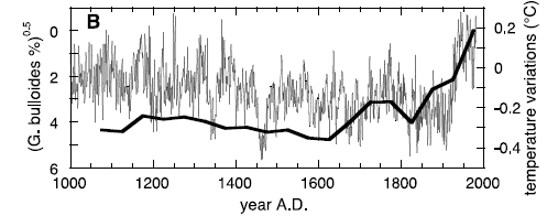
Anderson, Overpeck et al 2002. Fig. 2. (B) Time series of Northern Hemisphere temperature variations from (28 – MBH) (thin line) superimposed on the index linearly related to monsoon wind speed, the square root of the difference in composite G. bulloides abundance with respect to the 1975 average (thick line).
Now there’s nothing intrinsically objectionable about the idea that increased Asian monsoon levels can be associated with higher extratropical NH temperatures and there is certainly evidence in favor of such a hypothesis. If that were the case, then the increased Asian monsoon levels would be associated with upwelling offshore Oman and necessarily colder water in this particular locale. So that would imply that if you looked at SST records from HadSST and NOAA that one would see increased prevalence of cold water in the offshore Oman gridcell. What do you suppose the chances of that would be?
Here are plots of the corresponding gridcell from CRU and NOAA. Naturally, nothing ties together and, indeed, the discrepancies in the graphic merit detailed investigation. Both series show warming water – OK, but how does one explain the supposed increase in G Bulloides percentage. If the proxy is measuring changes in the 20th century, then there should be an increase in cold water because of increased upwelling (and the majority of sediment production is in the cold water season). In addition, the temperature increase at CRU since World War II is nearly half a degree greater than at NOAA – why is that? And what of the very high SSTs prior to World War 2 (there is negligible HadSST data for World War 2)? What does it signify?


4 Comments
Are these plots of annual temperature, or upwelling-season temperature anomalies?
Others and I have observed that if mercury metal is placed in a clear glass tube, the mercury can be seen to expand as the surrounding temperature increases. We are working on a way to present the data in a clear, peer-reviewed quantitative manner. We are hopeful that the method will detect temperature changes needing few assumptions about physics, chemistry, biology, satellite navigation, zoology, botany, ocean currents, eddies and the Navier-Stokes unsolved equations, Reynolds Number and the results of the last 10 USA lotteries as affected by carbon dioxide and ozone levels in the atmosphere, interpreted by multiple non-linear regressions and forcing models on supercomputers with added white noise. One present problem is a lady – she sells sea shells by the sea shore and tells myths to children.
Steve,
It seems that with the “B” chart going from +6 to 0, with 0 at the top, the chart is showing decreasing %GB at the HS end. Am I missing something?
Just on general principles can it really approach 0% as shown ?
Steve: I believe that this shows delta from 1975 levels.
Near-shore upwelling is a function of wind velocity (specifically “alongshore wind stress”). Using NCEP reanalysis data I plotted June thru August wind velocity near Oman (15-20N; 55-60E) to see how windspeed has varied in the last 50 years. I also plotted global surface temperature (NCEP/NOAA). The plot is here .
It’s hard to see any relationship, even when using 5-yr smoothed windspeed. The r-squared using smoothed windspeed is 0.19, which is not very impressive.
Seems like something presented as a causal chain (GW-Monsoon-Windspeed-Upwelling-Temperature-Bulloides) would have stronger links what the plot shows.