When I was a teenager, I liked Joseph Conrad’s books (which bear re-reading as an adult). I remember reading Younghusband’s account of his travels in Sinkiang. These books undoubtedly were a reason why I traveled round the world when I was 20, going to some out of the way spots. The Dulan junipers, which we’ve discussed lately, are in central Asia and I thought that it might be interesting to see if there was any connection to the Silk Road, the formidable overland route through Central Asia, traversing both the Gobi and even more formidable Taklamakan deserts.
It turned out that Dulan is connected in a very interesting way to the one – and one that casts an interesting perspective on their use as a temperature proxy.
First here is the location map from Shao et al, A 1437-year Precipitation History for the Northeastern Qinghai-Tibetan Plateau, describing a precipitation reconstruction from “Qilian juniper (Sabina przewalskii, Figure 1) growing in the mountains of the arid and semi-arid area in the northeastern Qinghai-Tibetan Plateau”. The figure is a little muddy, but you can identify the following key towns on this location map: Dulan, Wulan, Delingha and Chaka (Tsaka). Qinghai Lake (Qinghai Hu, Koko Nur) is a prominent geographic feature. The Shao et al junipers were sampled between 36 30N and 37 30N and between 97 and 99E.
dulan_19.jpg
Figure 1. Location map from Shao et al
Let’s step back a bit and locate the Dulan-Delingha are in the context of the Silk Road, a map of which is shown below. Dunhuang is located at 42N 92E and Lanzhou at 36N 103E. So the Dulan junipers are located in the sector between Dunhuang and Lanzhou, with the Gobi Desert to the north east and the very severe Taklamakan Desert to the west.
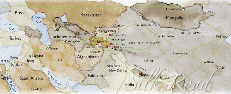
Figure 2. Map of the “Silk Road”.
There are different “filaments” to the Silk Road. In the sector between Dunhuang and Lanzhou, the main travel route today is in the “Hexi Corridor”/”Gansu Corridor”, but there is an alternative route via Xining and Delingha, passing near Dulan, which I will describe below. To avoid any confusion, I will first show a map of the Gansu Corridor to distinguish it from the Xining-Delingha route (since I had to work through this distinction to understand the geography.)
The left panel below shows a map of Gansu Province covering the “Hexi Corridor” or the “Gansu Corridor” between Dunhuang in the northwest and Lanzhou in the southeast. Major cities between Dunhuang and Lanzhou include Wuwei, Jinchang and Jiayuquan. For people interested in mining, Jinchang is the location of a huge nickel-copper deposit and industrial facility. A local description says that it is where “the oasis, desert and Gobi distribute in interlacement.” Zhangye, known as Ganzhou in ancient times, is the granary of the Hexi Corridor and a national-level historic and cultural city. Marco Polo once stayed there for a year. The city is known for the world’s largest indoor statue of Sleeping Buddha
Xining is shown in Qinhiang to the west of Lanzhou. The right panel, a location map from Sheppard et al 2005 about Dulan junipers, also locates the city of Xining, which is to the east of Dulan and the nearby juniper sites shown in the top figure and it is the Xining route that I will describe in more detail below.
 |
 |
Silk Road Travel Itineraries
An alternative route through Xining 101 34E 36 34N and the Dulan (36.4N 98E)/Delingha area, described in modern tourist itineraries.
The East Tibet Amdo and Silk Road itinerary describes an itinerary of 5 days from Lanzhou to Dunhuang “oasis” via Xining and Delingha, stopping in Delingha on the 4th night (“Day 8 below”) after a drive “over the Gobi Desert”. THe drive from Tsaka(Chaka) to Delingha goes right through the Shao et al location map. An interesting excursion in Dunhuang is described in which “camels carry you through the Singing Sand Dunes”. This service would no doubt be invaluable to the Crowley and Lowery quest for temperature proxies in the desert.
Day04 Lanzhou – Xiahe 280 km 1N in 2*Labrang hotel B/L
In the morning drive to Xiahe, which is 2,900 meters above the sea level and almost exclusively inhabited by Tibetans. In the afternoon visit Labrang monastery, the most important religious centre on the northeast border of the Tibet region. The monastery created in 1710, as one of the six grand monasteries in Tibet area, has served for centuries there to connect the Tibetan and Mongolian Lamaism.Day05 Xiahe – Xunhua – Tongren 260 km 1N in 2*Huangnan hotel B/L
On the way to Tongren make a stop in Xunhua (the first station in Qinghai province), to visit the hometown of the 10th Panchan lama and especially the divine lucky tree. In the legend he was finally recognized as the ” holy child ” by help of recognition of the Pappel tree near the house his family lived. Arrive at Tongren in the evening.Day06 Tongren – Xining 210 km 1N in 3*Qinghai hotel B/L
Visit Longwu monastery of Gelukpa sect which was initially constructed in Yuan Dynasty (1271-1368) as a monastery of Sakya–sect and Wutun village the center of Tibetan Regong-art, which is a successful mixture of religious art and folk art. Afterwards go to Xining, the capital of Qinghai province. This city is mainly inhabited with Tibetan but also a home of Uygur, Kazak and Hui minorities.Day07 Xining – Kumbum – Koko Nor 26 km + 160 km 1 N in simple tent hotel B/L
While traveling, visit Kumbum monastery (Ta’er Si) of Gelukpa-sect, which was built in 1560 in Huangzhong county and also one of the six grand monasteries in Tibet. Tsongkhapa, the founder of the Lamaism “yellow hat sect”, was born here. As Kumbum Monastery has always been playing an important role to connect the Mongolian with the Lamaism, today many Mongolian come to this place for worship. Then cross over Sun-and-Moon-Mountain (Ri Yue Shan). In 641 Wencheng princess of Tang Dynasty passed by this mountain where today a sun-pavilion and a moon-pavilion are built on the summit for people to have a break. The suns and moon mountain has always been an distinguish line between meadow and agriculture area. After that make a short trekking by the Koko Nor Lake, the biggest salty lake in China, with an area of 4500 square kilometers and an altitude of 3,194m. high above sea level. The big lake is acclaimed as ” pearl on the highland ” and the scenery of which is unusually fascinating and appears different shapes even at the same time. “Koko Nor” in Mongolian language means “blue lake” because of the lunar shape and the color of the lake.Day08 Koko Nor – Chaka – Delingha 460 km 1N in simple Haixi hotel B/L
After a appox. 200km long driving make a short stopover by the Tsaka salty lake where even the wind should be salty. Then drive over the Gobi Desert and arrive in Delingha in the evening.Day09 Delingha – Dunhuang 470 km 2N in 4*Solar Energy hotel B/L On the way cross over Dangjin Shan pass which is more than 4000 m. high above sea level. After a long journey arrive in Dunhuang oasis.
Day10 Dunhuang B/L
In the morning camels carry you through the Singing Sand Dunes to the beautiful Crescent Spring Pool (approx. 5 km away from Dunhuang). Time permitting, climb a 200-meter-high sand hill nearby.
A slightly different itinerary is decribed here, outlining a 3-day itinerary from Xining to Golmud (36N, 95E) via Dulan. The Qaidam (Tsaidam) basin is described as “desert with some oasis dotted in”. After Dulan, instead of going to Dunhuang, this itinerary goes via Xiangride oasis (36 00N 97 54 E) to Lhasa. Xiangride oasis, located in the top location map near Dulan, is said to be the “last oasis seen in this desert”. This is important information for prudent dendroclimatologists, who generally try to keep track of the “last oasis” in their quest for temperature proxies.
Day 01 Xining – Kumbum – Koko Nor Lake 210 km
In the morning drive to Kumbum Monastery (Ta’er Si) of Gelukpa-sect, which was built in 1560 in Huangzhong County and also one of the six grand monasteries in Tibet. Then cross over Sun-and-Moon mountain (Ri Yue Shan). The Sun-and-Moon mountain has always been an distinguish line between meadow and agriculture area. After that make a short trekking by the Koko Nor lake, the biggest salty lake in China, with an area of 4,500 square kilometers and an altitude of 3,194m high above sea level. The big lake is acclaimed as “pearl on the highland” and the scenery of which is unusually fascinating and appears different shapes even at the same time.
Day 02 Koko Nor Lake – Dulan 320 km
In the morning drive to Dulan along the Koko Nor Lake, the biggest salty lake in China, with an area of 4,500 square kilometers and an altitude of 3,194 m above sea level. In addition a small island known as “the heaven of the birds” lies in the lake. After an approx. 200 km long driving make a short stopover by the Tsaka salty lake where even the wind should be salty. Late in the afternoon arrive in Dulan.
Day 03 Dulan – Golmud 360 km
Drive through the Tsaidam basin, among which most part is desert with some oasis dotted in. This basin lies in the north of the Amnyemaqen Mountain and the road to Golmud is just along the foot of the mountain. The Xiangride oasis is the last one seen in this desert. Late in the afternoon arrive in Golmud, which is a civilization center where Tibetan culture and Han culture melt each other.
Here is an account of an overland trip form Lanzhou to Golmud (and on to Lhasa) by a geologist with some pertinent pictures, with the relevant section in Lanzhou starting here. In his page on the Qaidam lake, he oberved camels, near Tsaka (Chaka) lake. Dendroclimatologists are keen students of biology and some believe that camels are harbingers of a nearny temperature-limited proxy.

The traveller observes the following of Dulan:
The terrain becomes an arid desert, whose bleak expanses are punctuated by small green oases where a river exits the mountains. One of the largest oasis is Dulan, where the land has been reclaimed from the sands, and irrigation yields green fields. Lines of trees have been planted as windbreaks, in an attempt to halt the shifting dunes (right).

Again, keen-witted dendrochronologists are ever on the look-out for shifting sand dunes, as a temperature-limited proxy may lurk nearby.
Recent Archaeology
Some of the recent interest in Dulan junipers derives from their discovery in recently discovered tombs from the first mellnnium AD. Sheppard et al 2004 stated:
Between 1982 and 1999, large tombs that are thought to be remains from the time of the Tubo (Tufan) kingdom were surveyed, registered, and partly excavated….the textiles provide some chronological information by which the tombs have been dated roughly to the period from the fourth to the ninth century AD….
In 1999, numerous juniper trunks and wooden coffins from the tombs in the Reshui Valley, 20 km southeast of Dulan.
They compare their reconstruction with a time series of human occupation in the region (Chen et al., J Paleolimnology 1999).
Some even more recent archaeological discoveries in 2002 are mentioned here:
The Silk Road did indeed pass through Qinghai during the Tang period. Recent discoveries include unusual silver sculptural pieces,possibly of Sogdian provenance or inspiration, and of Byzantine coins. These underscore the point that significant trading routes ran through Qinghai, qualifying the corridor stretching from Xining to Golmud along the southern perimeters of both Kokonur (Qinghai Lake) and the Qaidam Basin as a Silk Road artery of significance. Dulan county was a hub of communications extending in different directions to Sichuan, Tibet and Central Asia, and along the Hexi Corridor to China in the Southern and Northern Dynasties and Sui-Tang period.
In 2002 Xu Xinguo’s discovery of painted coffin panels, the first known paintings of the Tubo-Tuyuhun period, during the excavation of two robbed tombs at Guolimu on the southern shore of Bayin Lake located 30 km east of Delingha city only serves to reinforce the picture of ethnic complexity that has emerged from Qinghai, making it clear that the Dulan area was a major centre during the pre-Tang and Tang periods. He outlined these most recent discoveries in the March 2004 issue of Cultural Relics World, arguing that these finds confirm his long-held belief that the Dulan area and its surrounds was the centre of a Tubo-Tuyuhun royal polity and that many of the graves discovered to date are those of the royal aristocracy that once dominated the area.
The Shao et al presentation showed a picture of a tree in a desert, which twq objected to. In correspondence with Prof Shao, she says that she did not know where the picture came from, as it was inserted in the presentation by a colleague and that the colleague is unable to recall the location of the picture as it was 5 or 6 years ago. I’ve read many geological reports and I’ve never encountered a situation where a geologist was unable to identify the location of a picture in a geological report. However, I think that it’s possible to reasonably hypothesize that the tree-in-the-desert picture in the Shao et al presentation came from the Qinhiang area somewhere near Dulan, as one can locate pictures of deep rooted trees in this area. Here is a description of the Qaidam desert which contains the following picture:

BTW just googling this area, it turns out that there are some interesting archaeological discoveries in the Chinese deserts that may have some bearing on climate change history. Here’s a recent report on a city discovered beneath the sands of the formidable Taklamakan desert that apparently disappeared in the Roman period.
Chinese and French archaeologists claim to have discovered the ruins of an ancient city which disappeared in the desert in Northwest China more than 2,200 years ago. The ancient city, shaped like a peach, is located in the center of the Taklimakan Desert …Carbon dating by French archaeologists shows that the city wall dated back 2,200 years. “We think the city had disappeared before the Western Han Dynasty (206 B.C.-25 A.D.) as we did not discover any relics of Western Han and of the historical periods after the Western Han,” said Abdurensule, adding this was the oldest city ever discovered in Xinjiang.
If you’re interested, you can locate information about other lost cities in the desert. Maybe you’ll find some dendroclimatologists questing for temperature proxies in the ruins.


26 Comments
Some info. on the ecological niche for this juniper is http://ourworld.cs.com/danwink/id62.htm?f=fs.
Evidently, they like hot, dry areas, just like most domestic junipers.
Just so there’s no misunderstanding – bristlecones are located in a “wickedly dry” mountain desert as well, but the wily dendroclimatologist, questing for the elusive temperature proxy, loves to hunt bristlecones as well.
In a way, I am a product of the Silk Road.
Some of my ancestors came to Eastern Europe via that road.
The question is, who is NOT part Chinese?
😉
Re #2
I wonder what twq thinks of the bcp photos in Fritts (1976)? On second thought, maybe I don’t.
Here are some nice recent pictures of White Mountain bristlecones, here here here
the locale of which is certainly “Wickedy dry” in Hughes’ phrase.
twq, please remember that there’s been a long dialogue at this site about bristlecones – and it’s not that we’ve singled Dulan junipers out for special attention. We’ve spoken out louder and longer against bristlecones and the seeming addiction of dendroclimatologists desperately seeking temperature to settle for the comfort of precipitation.
http://www.ii.uib.no/~petter/mountains/N5/TripReport.html
RE: #5 – Just to the west of where that photo was taken, by, oh, about 5 or 6 miles, you are standing in the foothills of the Whites as they grade into the Long Valley Caldera, a feature that is technically to the north of the Owens Valley proper. The last serious eruption there (massive, explosive, tuff producting …. ala, the dire predictions for Yellowstone, and, not to set it aside, a repeat in Long Valley!) was estimated at 700K YBP. Lots of extensive / basaltic rock in abundance. The climate is high desert, with wide temperature swings. The Sierra Nevada to the west of there are in the 12 – 14K ft range. During the rainy season (Oct – Apr/May) the fronts not only get squeezed out by the Sierra, but in general, lose a lot of steam as they pass 38 N latitude. Even at the coast, the precip drops dramatically southward – San Francisco – 21 in / year, Monterey – 17 in / year, Santa Maria – 12 in / year. In the San Joaquin Valley – Stockton – 14 in / year, Fresno – 10 in / year, Bakersfield – 7 in / year.
“Wickedy dry”?!
500mm is about 20 inches in old money. About 5 or so less than we get here in Cambridge (UK).
Last time I checked no-one here thought it was “wickedly dry”. Nor have I noticed that I live in a desert!
I guess they get something similar in terms of rainfall over at the University of East Anglia (probably not more than 40 miles of flat countryside to the East). I bet a pound to a penny that Hughes would not describe his locale as “wickedly dry”.
So why is he doing in this instance?
If anyone has a pdf of Gou et al, 2006, A comparison of tree ring records and glacir variations, Annals of Glaciology 43, 86-90 which seems to be what twq has in mind, could they please send it to me. The U of Toronto only has this journal in snail format at present. I went to one branch and discovered this and would like to avoid another trip.
Calgary, AB;
Avg Rainfall: 421mm
Avg Temp : 3.6C
Wickedly dry? Wickedly cold?
Seems to me the lack of soil is likely a limiting condition.
Four-page document, A comparison of tree-ring records and glacier variations over the past 700 years, northeastern Tibetan Plateau, pp. 86-90(5), available at http://www.ingentaconnect.com/content/igsoc/agl/2006/00000043/00000001/art00013 for $33.16 plus tax. I guess the entire publication (400+ pages) must cost a fotune at that rate. Might be worth the additional trip, after the phone call to ascertain they have it.
Re: #10
That was in response to #8. Also, change “fotune’ to fortune.
All these interpretations of data are based on the unproven assumption that the earth has remained fixed in its spatial orientation in space with respect to the sun, for example.
Admit ever the slightest “tippe toppe” effect, and those interpretations of past climates become problematical.
This is the single issue concerning interpretation of palaeoclimate – that the earth never ever changed its orientation in space during time.
OK all you keyboard experts, I have direct experience with California Bristlecone Pine areas. Whatever the claimed annual precip is there, most of it occurs as snow. We have high seasonality of moisture in California, with a nearly dry summer, monsoonal intrusions and small local mountain convection notwithstanding. Our snow (even ice) sublimates rapidly. Evaporation rates are very high (certainly much higher than East Anglia or anywhere else in the UK). The White Mountains are surrounded on all sides by desert, and even in the mountains themselves, are many desert microclimates. EOF.
#9
This information illustrates the problem of climate averages and tree growth and underlines Koppen’s struggles with climate classification very well. He identified B climates from all other types by precipitation, that is those which did not receive enough precipitation to support trees. He then subdivided these into those that supported grasses from those without vegetation or true deserts. He then had to further divide between hot and cold deserts – the polar regions are cold deserts.
His classification of B climates required a decision based initially on total precipitation, but then on how the precipitation was distributed throughout the year; what is generally called the effective precipitation. Since he was doing abroad classifications he had three categories for precipitation; even all year; 70% winter precipitation; and 70% summer precipitation. One of the points about Mediterranean classified climates (including California) is the precipitation is 70% in the winter and generally is the only climate type in which that occurs. This means you can have much lower rainfalls to achieve a higher effective precipitation because evapotranspiration is smaller.
When doing tree ring studies you should really be doing complete moisture balance analysis from year to year and from decade to decade. Thornthwaite and Mather expanded on Koppen’s work considerably and their work is the basis of models used for irrigation farming today, especially with high value crops. There is a great deal of theoretical and empirical work available on this because efficient irrigation requires knowledge of what is required to supplement nature and what makes the plants grow most efficiently. Potato irrigation is especially interesting because they can determine the shape and size of the potato by the pattern of moisture supply (Macdonalds requires a long thin white chip and this is only achieved by a steady regular supply of water).
The problem with these systems is they ignore snowfall. Thornthwaite and Mather assumed that when the monthly mean temperature reached zero C° there was no more input or output of moisture. Also as Parker showed in high altitude tree ring studies and Rouse confirmed with high latitude studies the amount of precipitation the preceding fall and the amount of snow cover through the winter were very important indicators of tree growth potential.
It seems like apples and oranges to compare mountainpeak BCP with desert oasis junipers. Many oases, after all, exist where large aquifers happen to come close to the surface – you’re not going to find that condition on a mountaintop.
I seem to remember Lee making an argument some months ago about groundwater providing these trees w/ H2O. If individual trees are completely supplied by groundwater, why couldn’t they be temp proxies [to the extent any trees faithfully record temp signals] ? It seems like the key would be to compare the ratio of rain water to groundwater that supplies the roots. If this is is sufficiently small, any variation in precip would seem like noise.
One would hope that anybody who did sample trees in a desert oasis would archive the trees’ proximity to a stable aquifer, if any, suitable to provide 100% of the trees H2O.
Jim Edwards, #15…
That is a valid point, at least on it’s surface. I wonder what effect a few inches of rain would have on a the growth rings of a tree which gets “100%” of it’s H2O from groundwater. My guess is, the growth will increase with precipitation, through water absorption through stomata, some minor (but non-zero) shallower root systems, and replenishment of the aquifer. a tree growing in the desert is probably not analogous to a hydroponic system.
#16
I’d think you’re right, as long as there isn’t a surplus of water in the ground, perhaps even then. All the more reason to document the local hydrogeology before sampling each tree.
You’ve probably already seen this tree ring study near Dulan, but just in case.
re #13. Steve, the point I was making is that Jones (as usual) was providing incomplete information to a credulous audience. As a scientist he should be explaining details in the correct context, not obscuring it.
PS no complaint about your reply (implicit or otherwise) which was highly inforamative.
Let’s take alook at the statement “There are no temperature proxies.” There is a good reason to believe this statement is true. To be a temperature proxy a tree must spend most of the growing season in temperatures that lie in one leg of the inverted U. If it spends most of the growing season in the flat part of the U, what little effect the temperature has on growth will be lost in the noise from other growth factors. Unfortunately, being in a leg of its temperature response most of the time greatly reduces its growth, and thus it will loose out to competitors of other species that are better adapted to the temperature. Therefore there are no temperature proxies.
This simple arguement explains why most trees are not temperature proxies. But it breaks down when there is another factor in which the tree has an offsetting or even greater advantage. The most common area would seem to be better adaptation to semidesert or swampy conditions. The downside of this however is that the tree is likely to be on a leg of water tolerence as well. There is going to be a confusion as to which variable the tree ring width responds to. Still no reliable temperature proxy.
Higher temperature means higher water use. therefore the temperature affects growth through both Us, directly through temperature leg and indirectly through the water leg. If a tree is stressed during its growing season by both temerature and water, the temperature variable will tend to dominate as it is present in both channels. This assumes that the changes caused directly by temperature and water variability are of approximatly the same size, or that temperature changes are larger. Temperature proxies may be possible.
There is a third way that temperature influences growth. This is when there is a correlation between temperature and effective percipitation, which is fairly common. As long as the effect of the change in effective percipatation on ring width is positive with respect to the effect of temperature on ring width, it reinfoces the temperature effect on ring width and thus amplifies the temperature signal. Temperature proxies are probable.
Near Steve is a temperature proxy that probably uses all three of these methods. Eastern white cedars grow on the face of the Niagara Escarpment. These cedars grow in small shallow pockets of soil and thus are highly water stressed. The northern range of these cedars is the tree line just south of James Bay so that they are not influenced by the lower leg of temperature response U in southern Ontario. However in hot summers the temperature can get high enough that it is likely on the upper leg of the temperature U comes into play fairly often. High temperatures also incease the water stress because of the higher water needs of the cedars Thus reinforcing any temperature signal.
The relationship between temperature and percipitation is not so clear. Hot temperatures can be coupled with a monthly percipitation of zero or above average rainfall. Cool temperatures generally show less variability. However effective rainfall for the cedars is a different story. Cold spring and summers generally have more frequent rains. These are light to moderate in intensity. The cedars benefit from most of the rainfall, as there is little runoff, even from their small and shallow patches of soil. Hot temperatures are generally associated with longer periods with no rain seperated by heavy rain produced by thunderstorms. Much of this rainfall is lost to runoff by the cliff face cedars. Thus the effective rainfall is much higher in cool temperatures even if there is no difference in actual rainfall. All three factors tend to favour more growth in cool growing seasons, while limiting growth in hot years and thus you have a temperature proxy.
Why do you look for temperature proxies in semideserts and swamps? Because that’s where they are.
RE: #20 – My personal observations of high arid flora in California are as follows. The following would constitute good growth years:
1) A good amount of snow pack, with a warm summer, such that the snow pack is not too great at during June and July. Any amount of summer precip (which is innately rare) is OK.
2) Poor snow pack but a strong summer monsoon. Tempertures cold to warm.
3) A nomimal winter and summer precip year with a cool summer.
Hot summers would actually retard growth, since these types of plants kick into dormancy under conditions of high heat.
4) A moisture starved summer, no matter what the temperature, will also retard growth.
Trees in arid environments are innately well adapted to cope with wide swings in temperature versus their perhumid counterparts, hence, the prevalence of evergreen as opposed to deciduous types. In order to maintain growth, they need to be able to grab moisture when it’s there, and move forward, even in surprisingly cold conditions. Only in bitter cold will they get as dormant as Eastern US trees do during the their own cold season.
Even in my area, in the transition zone between truly coastal forested areas and more inland semi arid ones, I observe these effect with my Coast Live Oaks, which are evergreens. They will drop leaves and stop growing either when dry or when thermally stressed above about 85 deg F. Only in the most cold (as in record cold) conditions have I observed leaf drop and slowing due to cold. In most years, growth is triggered by the Winter Solstice (which slightly precedes our annual precip maximum).
Re: 20
i live in western new york state. when i was younger and leaner, i worked as a rock climbing guide on the beautiful cliffs of the niagara escarpment, and used those cedars as belay and rappel anchors. in the case of the larger cliffside cedars, (and thus the longer-term proxies), a large root can generally be seen protruding into a crack in the porous dolomitic limestone. occasionally, a large block falls, usually over the winter due to freeze/thaw action. fine roots from the cedars are usually seen exposed, in areas which were formerly thin cracks in the rock. clearly, the tree was “making an effort” at procuring water from its precarious cliffside situation. being within eyesight of lake ontario, which does not freeze entirely in modern history, and acts to cool summer high temps, as well as warm the cold winters, provides anecdotal evidence of preciptitation proxy, rather than temperature.
as an aside, (and as a formerly active climber), this discussion has led me to wonder whether climbing records could serve as a proxy. certain climbs in the canadian and northern USA rockies were described as “rock climbs” by 1930s-era first ascensionists, when the modern-day difficulties on these routes are clearly ice/snow. i’ll try to look through some old climbing journals, and report on unthreaded later.
Dave (comment 21)
That these cedars, and probably all cliff side trees of any size, get water and nourishment from cracks in the cliff does not invalidate my arguement, only complicates it slightly. The relevant fact is that they are stressed by shortage of water for much of the growing season. My point is that there probably is no such thing as a temperature proxy that uses only the inverted U of temperature response. This does not invalidate these cedars as a temperature proxy. All three responses to temperature have the same effect: higher temperatures cause narrower ring widths. Cold dry climates present conflicting signals to a increase in temperatures. Warmer temperatures increase growth, but warmer temperatures also increase water use, which in a dry climate decreases growth. Barring other strng response to temperature, these trees will not be temperature prxies.
I am uncertain as to why you introduced the proxmity to Lake Ontario. I don’t claim that trees resond to anything but conditions at the tree itself. I havn’t seen Larson and Kelly’s 1995 paper, but I imagine at least some of the trees included in the study were in the Mount Nemo area northwest of Hamilton and quite some distance from the lake. This would mean there would be minimal influence of the lake on these trees except the general moderation of climate caused by the Great Lakes as a whole.
Doug, I understand your point. My point about proximity to Lake Ontario (I have climbed at Mt. Nemo, Rattlesnake Point, Buffalo Crag, Kelso, etc., hundreds of times. Lake Ontario is visible from Nemo and Rattlesnake) is in regard to temperature consistency. On the USA side of Lake Ontario, the lake plain of Niagara and Orleans county is the northernmost locale for growing peaches in the USA, due to the relatively warm winter conditions, and longer growing season, caused by proximity to the lake. In Canada, I am less certain about peaches, but the Niagara Region is a leading grower of wine grapes, and I am pretty sure some peaches are grown there as well.
These factors may well keep escarpment cedars closer to the middle of the inverted U than would be the case farther from the lake. Maybe that DOES make them better temp proxies. As usual, more study will be needed.
While these cedars apparently grow very slowly, they also appear quite healthy. I have noticed you don’t see a lot of dead cedars hanging around. They sure LOOK healthier than the pictures of high sierra bristlecones. They are old trees which are well adapted to cliffside conditions.
Well, thoroughly off topic, but Conrad will not just “bear re-reading as an adult”, he is one of the great novelists of the English language. In short stories his reputation rests on the Secret Sharer, Typhoon, The Nigger of the Narcissus, and the Shadow Line. In novels, Under Western Eyes, Chance, The Secret Agent, Heart of Darkness.
Not Victory or Lord Jim however….
i live in western new york state. when i was younger and leaner, i worked as a rock climbing guide on the beautiful cliffs of the niagara escarpment, and used those cedars as belay and rappel anchors. in the case of the larger cliffside cedars, (and thus the longer-term proxies), a large root can generally be seen protruding into a crack in the porous dolomitic limestone. occasionally, a large block falls, usually over the winter due to freeze/thaw action. fine roots from the cedars are usually seen exposed, in areas which were formerly thin cracks in the rock. clearly, the tree was “making an effort” at procuring water from its precarious cliffside situation. being within eyesight of lake ontario, which does not freeze entirely in modern history, and acts to cool summer high temps, as well as warm the cold winters, provides anecdotal evidence of preciptitation proxy, rather than temperature.
as an aside, (and as a formerly active climber), this discussion has led me to wonder whether climbing records could serve as a proxy. certain climbs in the canadian and northern USA rockies were described as “rock climbs” by 1930s-era first ascensionists, when the modern-day difficulties on these routes are clearly ice/snow. i’ll try to look through some old climbing journals, and report on unthreaded later.