Here are a few plots of Jones et al 1990 China urban vs rural sites. Maybe one of our more computer-oriented people could make a little applet to yield 42 comparisons from the small data set which is now collated. For now, here are some very quick and non-prettied up comparisons. I started with a couple of sites in western China because of the recent discussion of Dulan junipers. This is also useful because the leverage on these remote sites is very great because there are few observations and they affect large areas through the Jones gridcell methodology. (One thing to keep in mind with the Jones et al 1990 comparison is that it is only from 1954-1983, when there was much turmoil in China and that there is little trend in many stations. Chinese station temperatures took off more recently.)
First here is Xining (on the road from Lanzhou to Dulan) versus unidentified “rural” WMO station 53161. In this case, there is a pronounced trend in the urban centre while the rural centre is unchanged. Does this mean that there is a UHI trend in Xining? Note that the rural station is warmer than the urban station here.

Next here is a comparison of the two most remote western sites in the J90 comparison. There is somewhat of a trend in the urban site; whether the “rural” site has a trend or merely multidecadal volatility cannot be determined on the graph, but there is a difference between the two.

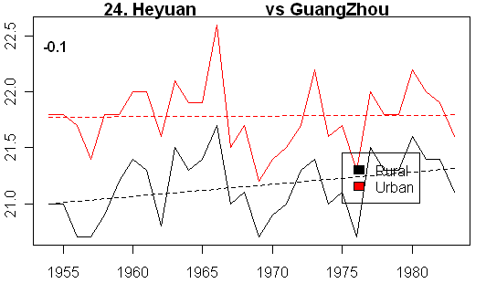
Steve Sadlov mentioned Guangzhou. Here’s a plot of the Guangzhou comparison to Heyuan. In this case, the “rural” location increased while Guangzhou remained relatively unchanged. Is Heyuan an example of exurban development?
Some of the comparisons look like there must have been some site change that is unaccounted for. For example, consider this graph where two series cross over. In this case, the “rural” station appears to warm while the city cools. Does this make sense?

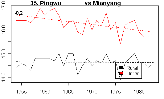
Here’s another comparison where the urban center shows cooling, while the rural comparandum remains unchanged. It looks as though there might be some non-homogeneity in the urban series in the early part, where it moved to a cooler location without being adjustment. In this particular case, this results in a reduction of the urban-rural UHI differential.
Having looked at all these series, my overall impression is one that this is very thin gruel to be using in big reports. This is supposed to be the best and the brightest?


45 Comments
Regarding the Chengdu cooling, I commented about this on another thread. The station, #56294, was located near the center of the city, but was then relocated, in 1971, to a western suburb, i.e. upwind from the center. Hence the cooling that you observed not only makes sense, it was predictable (even predicted—by me).
I would like to know what Jones et al. have to say about all this (including the other threads).
Sorry, where is the collation ?
Steve,
On what basis does Jones consider a site to be urban or rural? Why was China used rather than say the US or USSR? Based on what you’ve presented so far i.e. relative warming in some cooling in others I can were Jones probably gets his 0.05C UHI correction from. Perhaps we should be consider a UCI effect as well as a UHI effect? My general impression thus far is that the temperature measures here look just as problematic as the dendro data.
KevinUK
#2 fFreddy, the collated Jones 1990 station information together with names is at
http://data.climateaudit.org/data/jones90/jones90.location.dat . This gives Jones #, wmo, lat, long (minutes converted to fractions of a degree) and name identification.
The temparature time series from 1954 to 1983 are in
http://data.climateaudit.org/data/jones90/jones90.data.dat with the header in each column being the wmo number, the columns are arranged in the same order as the location data (unlike the original).
Rural stations are the first 42, urban stations are the second 42; the orders match.
Qitai has a population over 200,000 (see http://www.xist.org/cntry/subs/cn-65.aspx), so it is rather urban. Wulumuqi has a population of nearly 1.8 million. Both cities seem to be growing fast if one searches on them using google.
Also Chengdu has a decreasing population (http://www.xist.org/cntry/subs/cn-51.aspx) so perhaps that is why it is cooling.
Finally “rural” Heyuan has a population of 544,846 (http://www.xist.org/cntry/china.aspx). I guess a tabulation of populations of the rural and urban sites is needed.
If someone sends me a list of populations for the 42 “rural” sites (And the urban sites for that matter, I’ll incorporate the information into the ASCII reference file. If people send them in piecemeal, insert the Jones number as well to save me looking it up. Maybe some people can volunteer to do 10 each.
Some personal observation comparing Western countries with NE Asian ones with regards to development patterns. In the West, including even in crowded Europe, there is a reasonably good amount of arable land. In the countryside, as a result, there is a highly dispersed development pattern. Towns are small and even the regional service hubs tend to be small cities in the 5 – 20 thousand population range. This trend is at its most pronounced in the Americas, where rural areas can be truly devoid of substantial population. The trend toward larger properties and mechanization has only exacerbated it.
In NE Asia, in contrast, arable land is at a premium. In places like Japan and South Korea, it’s due to topography. In China, it’s due to the fact that most of the arable land is concentrated in the eastern quarter of the country, as is the lion’s share of the Billion plus population. Imagine 700,000 people living east of the Mississippi. As a result, you don’t see dispersed settlement patterns. Even “rural” areas have densepack. “Rural small cities” would qualify as major metro areas by Western standards.
Oops, missed a few zeros there. I meant “700,000,000 people.”
The meteorological data spans 1954–1983. So if you are interested in population estimates, they should be from that time, not 2000+. I am sceptical that reliable population data for that time exists—for the same reason that I was/am sceptical that reliable meteorological data exists. A quick search seems to confirm that, e.g.
There are, though, some UN estimates. E.g. Chengdu had estimated populations of 958000 (1955), 1835000 (1970), 2639000 (1985). Note that the estimate for 2000 (3294000) is substantially different than the 2000 census data cited in Douglas Hoyt’s comments (5268000), presumably because of a different demarcation of Chengdu.
Here are the elevations in meters for 80 of the 84 sites you listed.
50854 150
50949 136
54135 180
54497 14
50963 110
54324 176
50756 240
54616 11
54725 12
54476 N/A
54936 109
54852 72
54916 53
57193 53
57378 66
57584 52
57662 35
58144 19
58150 7
57799 78
58314 68
58251 5
58754 38
59293 41
59417 129
58477 37
58646 60
59501 5
57537 N/A
57606 977
56287 629
56751 1992
57253 100
57504 357
56193 894
57127 509
53863 745
53915 1348
51379 794
53593 910
52983 1875
53336 1290
50745 148
50953 143
53161 N/A
54342 43
50978 234
54237 182
50774 232
54511 55
54527 5
54662 97
54823 169
54857 77
57083 111
57073 155
57461 134
57494 23
57679 46
58027 42
58238 7
55606 N/A
58321 36
58367 7
58847 85
59287 42
59431 126
58457 43
58659 7
59316 3
57516 260
57816 1223
56294 508
56778 1892
57447 458
56386 440
56196 522
57036 398
53772 779
52889 1518
51463 947
53487 1069
52866 2296
53463 1065
A CA reader sent me the following link on unidentified site 52983 locating it at Yu Zhong.
http://weather.gladstonefamily.net/site/52983
It says:
I guess that was part of Jones’ careful site selection strategy.
I wonder if Jones et al site 53161 43 54N 125 20E is really 54161 Changchun 43.90N 125.22E. The Team always sets little booby traps to see if we’re on our toes.
831 205 54161 0 CHANGCHUN 43.90 125.22 238 283 U 1500 FL xx no -9 x -9 COOL FIELD/WOODS
re #4
What are the units for the temperature series? The range goes from -1 to about +225.
Plotting all the urban locations, the second set of 42, the 40 – 150 numbers (habitable?) look like they might trend up from 1954 to 1983. The others greater than 150 or less than 40 look flat, as one would expect as they might be less habitable.
It is pushing midnight here, so I may totally misunderstand the temp series, or am just seeing things.
Unidentified Jones city: 55606 lat – 28 36 long – 115 58
appears to be 58606 NANCHANG 28.60 115.92
I looked at GHCN stations within 1 degree of the lat-long’s from http://www1.ncdc.noaa.gov/pub/data/ghcn/v2/v2.temperature.inv
#13. Unidentified Jones site 52983 lat 35.58333 long 103.1833 is probably not Yuzhong.
In the China archive, there is also:
130 43 Linxia 52984 35.58 103.18 1917.0 1943 205 14539 16 Bullseye
which in GHCN v2 is:
904 205 56080 2 LINXIA 35.58 103.18 1917 2008 U 100 MV xx no -9 x -9
John N,
Divide those temps by 10 to get degrees celsius.
I might as well post up the elevations for the three new sites and add to the list. They might be an aid for some in visualizing the locations.
52984 1920m
54161 238m
58606 50m
For China data, don’t forget
#ndp039 http://cdiac.ornl.gov/epubs/ndp/ndp039/ndp039.html
#http://cdiac.ornl.gov/ndps/tr055.html
#http://cdiac.ornl.gov/ftp/ndp039/
and interim review of data sources #http://www.climateaudit.org/?p=1193
I’m not sure how easy it would be to try and adjust for biases. Take a look at the satellite image for Chengdu, for example:
google shot. How does one begin to account for the apparent industrial clouds (or is that “natural”)?
Maybe Chengdu looks a lot differently than it did 30-50 yrs ago, as do many of the cities in the study, but it looks like it could be a mess.
Further to my comment #11, there is the following.
(The author is currently a professor of sociology at the University of Washington.) Here is a quote: “Only six years ago, the total population of China was not known to within 100 million”.
RE: #21 – Typical Chinese city. Industrial smoke and soot, plus all the odd small coal fires for heating, small forges, etc. Some cities have it so bad, you get tricked into thinking there is high overcast on a perfectly sunny day without a cloud in the sky.
I played around in excel with the 84 sites referenced in #4. 34 of the 84 sites average above 15 degrees c. Those show very flat trends – basically no warming over the 30 years. The other 50 sites averaging below 15 degrees c generally show a slow warming trend.
If you wanted to claim a lack of GW you could show the warm sites. If you wanted to claim GW you could show you the cold sites. If you wanted to show a lack of UHI, you could give a summary answer of all sites, as the colder sites show some UHI between the rural and urban, which everyone has to believe that there is at least a little of. I suspect the flat liner sites above 15 degrees c, rural and urban, really dumb down the total UHI.
I have scrunched up excel charts of the 42 rural and 42 urban sites where you can see the warming and lack of warming. We will see if they make it. I know they are ugly. My apologies if they mess up the thread. Please feel free to destroy.
I’ve posted up Jones information in ASCII tab-separated format (readable to both Excel and R)
http://data.climateaudit.org/data/jones90/jones90.info.dat
This includes the name identification; the corrected wmo number (3 corrections); corrected latitudes (2 corrections) referring to TR055; GHCN v2 identifications; GHCN v2 altitudes, population code, population; xist.org populations (thanks to Doug Hoyt). The difference between GHCN v2 and xist populations is remarkable to say the least. HEre is the collatoin, but it’s easier to read the ASCII file
id wmo original ghcn data name lat long alt ipop pop xist.pop
1 50854 50854 50854000 205 Anda 46.38 125.32 150 U 110 473
2 50949 50949 50949000 205 Qian Gorlos 45.12 124.83 138 R -9 567
3 54135 54135 54135000 205 Tongliao 43.6 122.27 180 U 80 793
4 54497 54497 54497000 205 Dandong 40.05 124.33 14 U 450 780
5 50963 50963 50963000 205 Tonghe 45.97 128.73 110 S 20 203
6 54324 54324 54324000 205 Chaoyang 41.55 120.45 176 U 60 475
7 50756 50756 50756000 205 Hailun 47.43 126.97 240 U 75 733
8 54616 54616 54616000 205 Cangzhou 38.33 116.83 11 U 100 443
9 54725 54725 54725000 205 Huimin 37.5 117.53 12 S 20 604
10 54476 54476 54471001 205 Gaixian Xiongyue 40.17 122.15 20 R -9 NA
11 54936 54936 54945001 205 Juxian 35.58 118.83 107 S 30 1034
12 54852 54852 54863001 205 Laiyang 36.93 120.7 31 S 30 897
13 54916 54916 54916000 205 Yanzhou 35.57 116.85 53 U 100 598
14 57193 57193 57193000 205 Xihua 33.78 114.52 53 R -9 NA
15 57378 57378 57378000 205 Zhongxiang 31.17 112.57 66 S 45 1022
16 57584 57584 57584000 205 Yueyang 29.38 113.08 52 R -9 912
17 57662 57662 57662000 205 Changde 29.05 111.68 35 R -9 1346
18 58144 58144 58144000 60 QingJiang 33.6 119.03 19 U 110 NA
19 58150 58150 58150000 205 Sheyang 33.77 120.25 7 R -9 1053
20 57799 57799 57799000 205 Jian 27.12 114.97 78 U 100 409
21 58314 58314 58314000 205 Huoshan 31.4 116.32 68 R -9 333
22 58251 58251 58251000 205 Dongtai 32.85 120.32 5 S 40 1164
23 58754 58754 58754000 205 Fuding 27.33 120.2 38 S 25 521
24 59293 59293 59293000 205 Heyuan 23.73 114.68 41 S 25 2782
25 59417 59417 59417000 205 Longzhou 22.37 106.75 129 R -9 NA
26 58477 58477 58477000 205 Dinghai 30.03 122.12 37 S 37 369
27 58646 58646 58646000 205 Li Shui 28.45 119.92 62 R -9 348
28 59501 59501 59501000 205 Haifen Shanwei 22.78 115.37 5 R -9 344
29 57537 57537 57633001 205 Pengshui 29.3 108.17 311 S 27 540
30 57606 57606 57602001 205 Tongzi 28.13 105.83 972 R -9 575
31 56287 56287 56287000 205 Yaan 29.98 103 629 R -9 338
32 56751 56751 56751000 205 Dali 25.7 100.18 1992 R -9 186
33 57253 57253 57259001 205 Yunxian 32.85 110.82 202 S 30 584
34 57504 57504 57504000 205 Neijiang 29.58 105.05 357 U 240 1385
35 56193 56193 56193000 205 Pingwu 32.42 104.52 877 R -9 188
36 57127 57127 57127000 60 HanZhong 33.07 107.2 509 U 120 3480
37 53863 53863 53863000 205 Jiexiu 37.05 111.93 750 R -9 373
38 53915 53915 53915000 205 Pingliang 35.55 106.67 1348 U 85 453
39 51379 51379 51379000 205 Qitai 44.02 89.57 794 U 70 205
40 53593 53593 53593000 205 Weixian 39.83 114.57 910 R -9 778
41 52984 52983 56080002 205 Linxia 35.58 103.18 1917 U 100 168
42 53336 53336 53336000 205 Urad Zhongqi 41.57 108.52 1290 R -9 511
43 50745 50745 50745000 60 QiQiHaEr 47.38 123.92 148 U 1500 1540
44 50953 50953 50953000 60 HaErBin 45.68 126.62 143 U 2750 3695
45 54161 53161 54161000 60 ChangChun 43.9 125.33 238 U 1500 3225
46 54342 54342 54342000 60 ShenYang 41.77 123.43 43 U 3750 5303
47 50978 50978 50978000 205 Jixi 45.28 130.95 234 U 350 910
48 54237 54237 54236001 205 Fuxin 42.03 121.65 144 U 350 785
49 50774 50774 50774000 205 Yichun 47.72 128.9 232 U 200 814
50 54511 54511 54511000 60 BeiJing 39.93 116.28 55 U 8500 12843
51 54527 54527 54527000 60 TianJin 39.1 117.17 5 U 7210 8146
52 54662 54662 54662000 60 DaLian 38.9 121.63 97 U 1480 3245
53 54823 54823 54823000 60 JiNan 36.68 116.98 58 U 1500 3506
54 54857 54857 54857000 60 QingDao 36.07 120.33 77 U 1900 2721
55 57083 57083 57083000 60 ZhengZhou 34.72 113.65 111 U 1500 6656
56 57073 57073 57071001 205 Luoyang 34.67 112.42 136 U 750 1202
57 57461 57461 57461000 60 YiChang 30.7 111.3 134 U 150 1338
58 57494 57494 57494000 60 WuHan 30.62 114.13 23 U 4250 8312
59 57679 57679 57679000 60 ChangSha 28.2 113.08 46 U 850 2122
60 58027 58027 58027000 60 XuZhou 34.28 117.15 42 U 1500 1679
61 58238 58238 58238000 60 NanJing 32.05 118.78 12 U 2000 3405
62 58606 55606 58606000 60 NanChang 28.6 115.97 50 U 900 1844
63 58321 58321 58321000 205 Hefei 31.87 117.23 36 U 400 1659
64 58367 58367 58362000 60 ShangHai 31.17 121.43 7 U 10980 13065
65 58847 58847 58847000 60 FuZhou 26.08 119.28 85 U 900 2124
66 59287 59287 59287000 60 GuangZhou 23.13 113.32 8 U 2300 9496
67 59431 59431 59431000 60 NanNing 22.82 108.35 73 U 375 6463
68 58457 58457 58457000 60 HangZhou 30.23 120.17 43 U 1100 4502
69 58659 58659 58659000 60 WenZhou 28.02 120.67 7 U 250 1915
70 59316 59316 59316000 60 ShanTou 23.4 116.68 3 U 400 4944
71 57516 57516 57516000 60 ChongQing 29.58 106.47 351 U 3500 10266
72 57816 57816 57816000 60 GuiYang 26.58 106.72 1074 U 1500 2374
73 56294 56294 56294000 60 ChengDu 30.67 104.02 508 U 2000 4645
74 56778 56778 56778000 60 KunMing 25.02 102.68 1892 U 1300 5781
75 57447 57447 57447000 205 Enshi 30.28 109.47 458 S 40 755
76 56386 56386 56385001 205 Leshan 29.57 103.75 424 U 250 1135
77 56196 56196 56196000 205 Mianyang 31.47 104.68 472 U 52 1129
78 57036 57036 57036000 60 XiAn 34.3 108.93 398 U 1900 5345
79 53772 53772 53772000 60 TaiYuan 37.78 112.55 779 U 2725 2558
80 52889 52889 52889000 60 LanZhou 36.05 103.88 1518 U 1500 2087
81 51463 51463 51463000 60 WuLuMuQi 43.78 87.62 919 U 500 1753
82 53487 53487 53487000 205 Datong 40.1 113.33 1069 U 300 1526
83 52866 52866 52866000 60 XiNing 36.62 101.77 2262 U 250 854
84 53463 53463 53463001 60 HuHeHaoTe 40.8 111.63 1063 U 700 1407
The temperature versions at TR055 appear to match the versions now at CRU.
Steve, thanks for the data. You say:
Not only are the differences remarkable, the differences are greatly skewed between the rural and urban stations in the two datasets. Here are the figures for the xist population/GHCN population:
xist/GHCN Rural = 1796% (95% CI = 894% to 2697%)
xist/GHCN Urban = 420% (95% CI = 275% to 566%)
Another way to look at it is the difference between the average “rural” and “urban” population centres. In the GHCN data, the rural centers average 84,000 people, and the cities average 1,812,000. Thus the cities average 22 times the population of the rural centres.
In the xist data, on the other hand, the rural centers average 838,000 people, ten times the GHCN population, and hardly “rural”. The cities average 3,787,000, only twice the GHCN figures. In the xist data, the cities only average 5 times the population of the “rural” centres.
Once again, we have climate scientists using very dubious data to draw statistically unsustainable conclusions. As I pointed out in a post on another thread, the overwhelming majority (68 of 84) of the stations show no significant trend, and out of the 42 paired stations, only three pairs are statistically different. Add that to the dubious population data … I say there is not one meaningful conclusion that can be drawn from this dataset.
w.
While I appreciate the need to quantify UHI effects, they may actually be a secondary question. Even if you are able to make heads or tails of the Jones data, I would wager that one would still need substantially more information to reach any solid conclusions.
http://pafc.arh.noaa.gov/climvar/climate-paper.html, reads in part:
Anchorage’s population is around 300,000. It sits on a little glacial outwash that is about 10 miles north-south and about 8 miles east-west. The lower end of Ship Creek is in northwest Anchorage at approximately 10-20 FT above MSL, where temperatures are greatly affected by Cook Inlet. Both the downtown area and the international airport are on the west side at about 100 FT MSL. The seawater in Cook Inlet also affects the temperatures of these areas, but less so than the Ship Creek by noticable amounts. Merrill Field is approximately 2 miles east of downtown and farther from the water. There are many days when temperatures at Merrill Field are about 5 degrees F different than the international airport. The east side of the Anchorage Bowl (Muldoon area) is about 6 miles east of downtown at about 300 FT MSL. Just east of Muldoon are the Chugach Mountains. I would guess the tree line is only approximately 8 miles east of dowtown at about 1500-1800 FT MSL or so. See http://www.muni.org/iceimages/Planning/vicinity.gif for a vicinity map.
During the warmest and coldest days each year, the temperature differences in the few miles between MSL and 300FT MSL can be 15-20 degrees F. Maybe this particular town is unique, or maybe there are a lot of towns where temperature can vary this much in just a few miles. However, moving any weather station opens the whole issue to a far greater uncertainty than any estimate of the UHI effect I have seen.
I would want to see proof of very good recording keeping in the Chinese data regarding the actual location of each station for the whole of recorded period before I would believe any conclusion at all about UHI calculations.
The following shows whether on not a station relocated, during 1954–1983. Only the 35 stations for which histories are available are listed. An “X” indicates at least one relocation; an “=” indicates none; a “?” indicates inconsistent history. (A * indicates an incorrect station number.)
50745   X

50953   X

51463   X

52866   X

52889   X

53463   =

53772   X

54161*  =

54342   =

54511   X

54527   (first year only)

54662   X

54823   =

54857   ?

56294   ?

56778   =

57036   ?

57083* (first year only)

57127   X

57461   ?

57494   X

57516   =

57679   X

57816   =

58027   X

58144   X

58238   =

58367   X

58457   X

58606*  X

58659   =

58847   =

59287   X

59316   ?

59431   X
As an example of inconsistent history, consider station #56294. This shows its address in the 1970s being “as above”, referring its address in the 1960s. The longitude of the address, however, changed from 104°04′ to 104°01′ (about 4 km).
#3
OK I’ve continued to read the rest of this thread and the others related to it. This far it’s clear that there are lots or problems with this dataset that is used as the primaty proof of negligible UHI effects in the mean global surface temperature currently claimed warming trend. What other alternative studies exist which have looked into the UHI effect where there are large difference between rural and urban populations (Europe, US/Canada, USSR, India)?
KevinUK
Further to my comment #28, I now see that there are inconsistent histories for stations 54342, 58238, and 58659. Thus, each of those should be marked with “?” (rather than “=”). Such inconsistent histories further emphasize the poor quality of the data.
The 84 stations can be classified as follows:
49 with no histories;
08 with inconsistent histories;
18 with substantial relocations;
02 with single-year relocations;
07 without relocations.
Separately, note the following from p.64 of the CAS-ORNL report: “station (No. 54852) shows identical July and August temperatures over the period 1973–1975″—the indication being that the data (from a station among the 49 without histories) is unreliable.
Ren et al looked at urban heating in China and found that 65% to 80% of the warming was due to UHI for 1960 to 2000. The paper is discussed at http://climatesci.colorado.edu/2007/03/16/two-papers-on-the-urban-heat-island-effect-on-temperatures/
Population growth in Chinese cities from 1950 to 2000 is tabulated at http://www.xist.org/charts/cy_aggmillion2.aspx If you use the populations there and the following formula to calculate the trend in temperatures caused by growth in urban development:
UHI trend = 1.5 * log (pop2000/pop1950)/ 5
where 5 is for 5 decades, pop2000 is the population in 2000 and pop1950 is the population in 1950. You get a predicted UHI warming of 0.190 C/decade for the 139 listed cities.
The formula above is pretty standard and comes from Torok’s study of UHI in Australia.
HadCRUT3 gives a warming for eastern China of about 0.238 C/decade (from CO2science website) so it looks to me like about 80% UHI warming may be about right as Ren et al conclude.
Further to my comments in another thread that discuss the moves of individual stations….
Station #57679 moved 24–25 km; map shown below (from http://www.informath.org/WMO57679.png)
Station #57127 moved 10–11 km; map below (from http://www.informath.org/WMO57127.png)
Station #57494 moved 20–21 km; map below (from http://www.informath.org/WMO57494.png)
The brown-shaded area shows the city proper; the metropolitan area is much larger. There were actually three locations in all; the third is not shown (it followed a move that occurred in mid 1982).
(Note that Wuhan is one of the two cities analyzed by G.Y. Ren et al. [GRL, 2007]. The authors begin their analysis in 1961, the year after the relocation shown in the map.)
KevinUK, you ask a good question:
The abstract of a recent study in Climate Research [CR 33:159-169(2007)] says:
Note that over the last 50 years, the increase in maximum temperatures was twice as large as the mean rate for large urban sites, and the increase in minimum temperatures was five times as large. This means that the mean temperature increase in urban areas was 3.5 times as large as the mean rate statewide. The mean rate statewide was 0.2°C/decade, so that means the urban sites averaged 0.7°C/decade … I’d call that significant UHI warming myself.
Unfortunately, the full report is extremely expensive (€80), so I think I’ll have to pass on it … there is also an interesting analysis of trends in California temperatures by county at Warwick Hughes’s site.
As a rough rule of thumb, Studies by Torok et al. (2001) and Oke (1973) indicate that the UHI effect is about 1.5°C * log(population/population0). The data on Warwick Hughes page, however, gives a slightly higher value of 1.8°C.
w.
re: #35 Willis,
And for those wondering, the 1950 world population was 2.556 billion and the 2000 world population was 6.081 billion (according to the first site I turned to) which gives an *expected* UHI according to that formula of .565 deg C. Given that the Jones figure used is .05 deg C for an entire century, and the total temperature rise for the century was about .7 deg C, It’d seem to me that the UHI question needs some real examination.
BTW, grabbing the 1900 & 2000 figures from Wikipedia (1.650 and 6.071 billion) I get .85 deg C expected UHI for the entire century, which is actually, I believe, more than the actual observed warming. So, just how strong is the evidence for the UHI formula? You can’t try to justify it simply by looking at population in a few cities since the population signal and the putative AGW signal will be highly correlated in any case. You need to find locations which have experienced both very high and very low population increases and which are isolated from confounding problems like other nearby urban areas or say areas of major land use change.
Dave, an interesting post. I don’t know the answer to your questions. The Torok paper is available here. He gives a value of 1.42 log population. I’ve never been able to locate the original Oke paper, but there is an analysis of it (by the usual suspects) here. Dr. Oke has written extensively on the question, a list of his publications is here.
However, of course, such a rule of thumb is just that. UHI varies by latitude, with colder regions having a greater winter UHI for a given population than warmer regions. For an extreme example of UHI in a small town, check out Barrow, Alaska.
w.
RE #37
The Barrow UHI study is worth reading & understanding. Keeping in mind it’s an arctic site, it’s still remarkable that it has such an easily detectable UHIE w/a mere 4600 population in a windy, exposed coastal location. Another is that they conclude most of the UHI comes from direct energy conversion. I thought that aspect was negligible at least in my region — that most UHI seems to result from solar heating on dry, heat-retaining urban surfaces like concrete/asphalt/roofing.
Yeah, right, we (Jones, IPPC, media) “know” that global UHI is only .05C for the last century.
This from the Idsos:
http://www.co2science.org/scripts/CO2ScienceB2C/articles/V10/N21/C2.jsp
RE: #38 – one need only look at the explosion in high tension power lines and stand alone motors since 1900 to see just how much of UHI is due to energy conversion. All those electrons and BTUs need to do some work and they have and continue to do so.
And the original abstract:
Temporal change in urbanization-induced warming at two national basic meteorological stations of China and its contribution to the overall warming are analyzed. Annual and seasonal mean surface air temperature for time periods of 1961-2000 and 1981-2000 at the two stations of Beijing and Wuhan Cities and their nearby rural stations all significantly increase. Annual and seasonal urbanization induced warming for the two periods at Beijing and Wuhan stations is also generally significant, with the annual urban warming accounting for about 65-80% of the overall warming in 1961-2000 and about 40-61% of the overall warming in 1981-2000. This result along with the previous researches indicates a need to pay more attention to the urbanization-induced bias probably existing in the current surface air temperature records of the national basic stations.
twq, where r u?
One of the things that has come out of my first inspection of the GISS stations is the tremendous increase in the proportion of stations in the post-1990 period that come from urban airports. This is because the majority of the updated data in CRU and GISS other than the U.S. is from the automated airport weather system. I suspect that this may underpin the fanatical obstruction from CRU to even identifying their stations.
So it’s not just a UHI effect but an urban airport effect. I’ll do a post on this some time. In Toronto, the landscape around the airport has been urbanizing very rapidly. It was on the outskirts of the city when I was a boy and now it’s urban. This must be happening all over the world.
Ren et al. (2007) Fig. 3 has urban temperatures cooler than rural, right up to 1990. That’s more than half the reason for the urban vs. rural trend difference. Curious. That’s not normal. Is this a case of agri-rural vs forested/pre-airport, with agricultural warmer than forested pre 1990??
Then, a curious statement (bolded) in the conclusion (context kept, for accuracy):
I’d like to see the data and code for this whole paper.
Just noticed for the first time the comment in the opening post:
Duly noted!
It seems to me that since we are looking at temperature anomalies, a more productive way to classify stations is “high growth vs no growth” or “high development” versus “low development”. As noted above you can find UHI in towns of 4600 people. Based on what I saw in the census data for Cambridge Bay, Canada you could easily find UHI effects in towns of 1000 that have grown in the number of buildings by 50% in 20 years.
I assume that in China there is also the possibility of UHI tied to dramatic improvements in SOL with the parallel increase in energy consumption.
I was also interested to see that the just released paper on CO2 emissions uses a model that has population growth as a primary driver of energy consumption – the Kaya identity. The model suggests on its face that UHI should be calculated by correlating temperature changes with net changes not density per se: The rural urban distinction is bogus both in terms of actual station classifications and as a means of evaluating the UHI with respect to estimates of changes in global temperatures. This is yet another reason a reluctance to provide the locations of stations. There is almost a guaranteed positive correlation of local temperature and local population growth that would have to be partialled out before any crude aggregation! I recall seeing an equation that estimates this effect, at least on a global basis.
3 Trackbacks
[…] climateaudit, noting that questions about these claims were raised here (for example, here here and here . Since then, we’ve also looked at adjustments in the USHCN, GHCN and GISS networks, observing […]
[…] 2007, following receipt of the data, I did a number of posts at CA on the Chinese network e.g. here here here here here, analysis that we now know that Jones was monitoring. One of the few mentions […]
[…] Immediately on receipt of this information, I wrote some interesting posts on Chinese stations here here here . Doug Keenan followed up on this information as […]