Barker et al. [Science 2001] studied two glacier-fed tarns (micro-lakes) high on Mount Kenya -, Small Hall Tarn (SHT) at 4289 m and Simba Tarn (ST) at 4595 m.
They noted that prior studies [ Rietti-Shati et al, Science 1998; Karlen et al, Ambio 1999] on Hausberg Tarn (4370 m) on Mont Kenya had shown the following:
A 3000-year d18O diatom record obtained from Hausberg Tarn [4370 m above sea level (asl)], a glacier-fed lake on the northwest flank of Mt. Kenya (5), contained short-term minima in d18Odiatom attributed to glacier melting and longer term minima attributed to increased water temperatures (5, 6), in contrast to the positive relation assumed between d18O and air temperature in ice-core studies (7).
They describe local precipitation sources as follows (which is presumably similar to Mount Kilimanjaro, Thompson not providing any information):
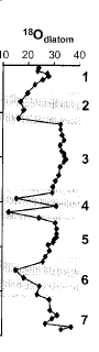
Precipitation in the summit zone of Mt. Kenya falls mainly from March to May and in October and November, although some occurs in every month. Total precipitation declines with altitude above the tree line (~3000 m asl) and is <900 mm -1 above 4500 m asl, where it mainly falls as snow (3). The main moisture source is the southwest Indian Ocean, because of southeasterly airflow in the lower troposphere during the rainy seasons (3, 8). Mean annual temperatures are close to freezing at both sites (1.3°C at SHT, -0.7°C at ST), with a monthly variability of 1-2°C but a large diurnal range (10° to 20°C) (3).The cores show contrasts in dO18. In periods of elevated dO18 (zones 1, 3, 5, 7) diatom-species richness and green algae levels were the highest. contrasting periods with negative dO18 excursions occur which are accompanied by high magnetic susceptibility values. The diatom assemblages are dominated by Fragliaria and the high magnetic contents evidence allochthonous sediment inflow.
The synchronous timing of the negative diatom dO18 excursions and the high magnetic susceptibility are shown below:
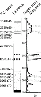 |
 |
Detail from Barker et al. Figure 1.
They focus on the negative excursions at several periods as shown in the graph below.
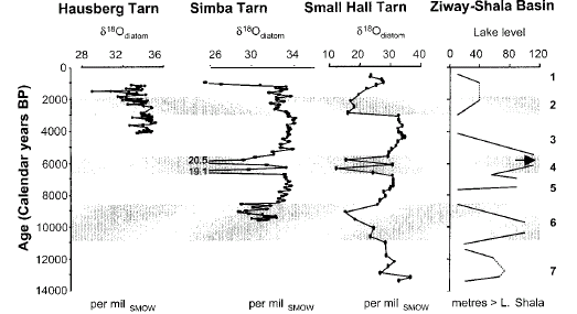
Barker et al. Fig. 3. Isotope data from Simba Tarn, Small Hall Tarn, and Hausberg Tarn (5). These data are compared to lake levels in the Ziway-Shala Basin, Ethiopia, derived from 14C-dated shorelines (32-Street-Perrott, Nature 1990).
They argue:
The similarity of the ST, SHT, and Hausberg Tarn isotope curves indicates underlying climate forcing modified by local hydrological factors. At tropical stations, the d18O values of monthly rainfall (d18Oprecip) exhibit a far stronger stronger correlation with total precipitation (the “amount effect”‘?) than with air temperature (14, 15).
They point out that at the LGM, the gradient between the ocean and the continent was reduced, leading to a weaker monsoon and reduced "amount effect", thus contributing to the "high values of dO18 (maximum +36.7 per mil) recorded on Mt Kenya in the late glacial period (14 to 11.2 ka).". (Note that high dO18 in glacial periods is opposite to a Thompson view of the world.) Barker et al.:
Unfortunately, the modern isotopic composition of precipitation on Mt. Kenya is unknown, apart from spot dry-season measurements measurements of ; 10 to 12 per mil at 4200 m asl (5). However, d18Oprecip values at Kericho (2130 m asl) and Muguga (2070 m asl) in the Kenya Highlands are ~ -4.4 and -3.8 per mil, respectively (14), the most negative isotopic values occurring during the wet seasons. The monthly d18Oprecip values for these stations (22) lie close to the global meteoric line, indicating that precipitation formation occurs under isotopic-equilibrium conditions, with minimal evaporation of rainfall (23). For d18O, the impact of orographic uplift is ~22.7 to 22.9 per mil km-1 in East Africa (24). This suggests that d18O precip at our two study sites averages around 210 to 211.5 per mil. These estimates are compatible with spot measurements of -9 per mil on river runoff from 4000 m asl (24), -8 per mil on surface snow from the Lewis Glacier (4), -6 to -7 per mil on Hausberg and Oblong Tarns (open lakes fed by glacial meltwater), and 11 per mil on Naro Moru Tarn (a closed lake) (5).
During wetter intervals in the past, the mean isotopic values of lake water would have been lowered by increases in precipitation (14, 16, 25) and cloud height [giving lower cloud-top temperatures (23, 26)], strongly reinforced by decreased evaporation and possibly by lake overflow (in the case of SHT).
A comparison of the Holocene variations in d18Odiatom (Fig. 3) with alkenone SST estimates for the southwest tropical Indian Ocean, the source of much of the precipitation on Mt. Kenya, shows that the isotopic minima around 9 ka and at 6.9 to 5.8 ka corresponded to high SSTs (27 – Sonzogni et al, QSR 1998 ).
At present, heavy seasonal rainfall totals over the eastern Kenya Highlands are strongly linked to positive SST anomalies over the tropical South Atlantic and Indian Oceans, as well as to El Nino-Southern Oscillation events (28). The heavy rains of 1961-1962 provide a modern analog for the abrupt, high-amplitude d18O diatom minima. In November 1961, for example, the precipitation on the footslopes of Mt. Kenya exceeded 275% of normal (28) as a result of onshore flow from a large area of anomalously warm SSTs in the western Indian Ocean. Evaporation was also greatly reduced by dense cloud (29).
Our data suggest that anomalously heavy snowfall on the peaks of Mt. Kenya may contribute to the neoglacial ice advances dated ~5.7 ka, 3.2 to 2.3 ka, and 1.3 to 1.2 ka (6).
What does this mean for Thompson’s interpretation of Mount Kilimanjaro? First, it seems to me that Thompson’s arm-waving identification of the negative dO18 excursions at Mount Kilimanjaro with solar minima and, in particular, his identification of the Wolf Minimum with excursion #2 are very speculative at best. On the other hand, the existence of these glacial tarns through the Holocene certainly suggests that glacier-fed tarns are a recurrent feature in the Holocene, arguing both for the existence of glaciers (either more or less continuously or at least periodically.) Thompson’s year 4200 event which he highlighted does not appear at Mount Kenya – why is that? It’s frustrating that Thompson, the later article, doesn’t bother reconciling to Mount Kenya.
The negative excursions are surprisingly episodic- why is that? Since the negative excursions are associated with high turbidity, it looks like they are associated with periods of glacial melt (as well as with high snowfall – the negative dO18). I can think of two contrasting opposite states: no glacier and no melt; and a frozen glacier and no melt. Would it be possible that there are episodic periods of very high snowfall creating transient glaciers – with the long periods of high dO18 in the tarns representing absent glaciers? What accounts for the two excursions around ~6000 BP?
Reference:
P. A. Barker, F. A. Street-Perrott, M. J. Leng, P. B. Greenwood, D. L. Swain, R. A. Perrott, R. J. Telford, K. J. Ficken, 2001, A 14,000-Year Oxygen Isotope Record from Diatom Silica in Two Alpine Lakes on Mt. Kenya, Science 292, 2307-2310


23 Comments
A. What is in the core ofdiatoms? Is it just diatom residue or other stuff? And what parts of the diatom are left? Does it ever vary because of biological (eating) processes, what the core looks like chemically? Is it Fe3O4? That would be magnetic.
B. I assume that the correlation of magnetism to O18 has to do with amounts? Not that the O18 is more magnetic?
C. Does the O18 represent what the water was? Or is there some concentration effect?
D. Have studies been done on current lakes to evaluate what goes on with O18 deposition? (recorded experiments to help validate assumptions on the cores)?
E. What is general feeling about this field in terms of dangers of confounding variables? Better, worse than other proxies?
F. “Unfortunately, the modern isotopic composition of precipitation on Mt. Kenya is unknown, apart from spot dry-season measurements…” (well they are upfront about the lack of foundational observed studies to help undergird the historical analyis, but it seems like in this field there is too much of a tendancy for people going after the big prize (historical core) and not doing the grunt work that would help it actually mean something.
G. “The negative excursions are surprisingly episodic- why is that? Since the negative excursions are associated with high turbidity, it looks like they are associated with periods of glacial melt (as well as with high snowfall – the negative dO18). I can think of two contrasting opposite states: no glacier and no melt; and a frozen glacier and no melt. Would it be possible that there are episodic periods of very high snowfall creating transient glaciers – with the long periods of high dO18 in the tarns representing absent glaciers? What accounts for the two excursions around ~6000 BP?”:
a. what do you mean “episodic”? (Brief?)
b. where did turbidity come into the story?
c. How can you have “no melt” and still even have a tarn at all or an )18 measurement at all? Shouldn’t tarn be dry then?
B. the correlation is because of associated minerals. The low dO18 periods have more sediments and it’s the sediments that cause the magnetic readings. I’m assuming that more sediments imply more runoff.
G a. Look at the spikes in the figure.
b. from B.
c. presumably there’s still precipitation. Maybe there’s been a glacier all along and runoff all the time.
I’m not trying to answer all the questions about these tarns and don’t know them anyway. The take-home point for me is the direct contradiction of Thompson’s assumption for Kilimanjaro that low dO18 meant cold temperatures. This is directly contradicted here and Thompson makes no attempt to reconcile this. This is an ongoing issue for Thompson – his whole schtick with tropical glaciers is based on the assumption that low dO18 is associated with cold temperatures, when the most obvious interpretation, based on observations, is that low dO18 is associated with heavy monsoons.
hmmm…and heavy monsoons are associated with low temp? Or is he just trying to say that same trend occurs as with polar cores? And what is supposed to effect the polar core O18 amounts?
NO, the monsoons occur in summer. So the relationship between temperature and dO18 is the REVERSE from the poles – summer has low dO18 and winter has high dO18 – also see posts on Thompson in right frame. Thompson argues that INCREASING dO18 levels at Dunde and Guliya in the 20th century “prove” global warming – no mention of this at Kilimanjaro.
(don’t get Snack on me). I know that summer is warmer than winter. The question is do colder summers mean more monsoon? I guess intutively, you would say no, since it means the summer is more winter like, but may not be that simple. Also if it is a tropical climate, summer is not so much colder than winter regardless.
The proximate effect is more precipitation. I haven’t looked at the relation, but my guess is that the variability in monsoon precipitation is hugely greater than the variability in summer temperature and any correlations are very slight. The proxy issue – if you’ve got an annual measurement only – is that you wouldn’t be able to distinguish between more summer precipitation and a change in temperature.
re 5
Mt Kenya is 20 km south of the equator, summer and winter are a bit academic here…..
I recall papers by people who have studied Kilimanjaro and Kenya over many years arguing that glaciation on these mountains is much more strongly affected by humidity and precipitation rather than local temperature.
Sorry for the lack of references – I lost all my climate stuff in a computer crash earlier this year. I’ll do some googling and will post again if i can find them.
Re: 8, glacial mass balance in all areas, not just the tropics, is the sum of the gains plus the losses. While the losses (melting) are temperature related, the gains (snowfall) follow a more complex pattern. Sometimes snow increases with increasing temperature, and sometimes it decreases.
Another factor is the interaction of wind and temperature. Most glaciers are at high elevation, and for the glacier to build up, the snow not only has to fall, it has to stick. Dry, powdery snow is easily blown off, making those lovely tails that we sometimes see blowing off of high mountains. Wet, damp snow, on the other hand, sticks well and tends not to blow off. Curiously, this means that when the temperature is a bit warmer, the snow will tend to stick more, and the glacier will grow more.
The variations in temperature and snowfall are also different. The variation in snowfall can go from zero snow one year to metres of snow the next. This is a much greater variation than we see with the average annual temperature, which changes much less from year to year, and thus will melt a little more one year and a little less the next.
For the last few years, snowfall has increased on both the Greenland Plateau and the Antarctic, and thus the ice fields in both places has been thickening.
Go figure … at the end of the day, though, one thing is clear.
Glaciers are not thermometers.
w.
Here we go:
International Journal of Climatology, 24, 329-339, doi: 10.1002/joc.1008, March 15, 2004
Click to access kaser_etal_2004ijc.pdf
Note this is about the 20th century decline in glaciation, not the paleo stuff that is the principal subject of the thread.
So who’s getting Snack with who TCO ? Just cos’ you got called on something…
… but wait, there’s more.
In the interests of balance, lead author Kayser doesn’t dismiss a link with global warming:
“There is a strong link between conditions on Kilimanjaro and global warming,” says Kaser. “But this does not necessarily affect in a simple way, such as rising air temperatures melt glaciers. Any interpretation of our findings toward ‘no climate change’ are entirely wrong.”
http://www.thepost.com.pk/apr_vis.aspx
Sorry Steve, I realise this is rather OT, but interesting nonetheless, in the sense that they reinforce the view that the ice cores on Kilimanjaro are poor temperature proxies.
Are there a couple of typos in the sentence “Mean annual temperatures are close to freezing at both sites (11.3 °C at SHT, -0.7 °C at ST), with a monthly variability of 62 °C but a large diurnal range (10 ° to 20 °C) (3).” ?
11.3 °C seems not near freezing, and 62 °C seems much too large for “monthly v
Ed, I meant Sid, not Snack. Sorry, got you guys confused.
Steve did not call me on anything. I’m aware of the monsoon effect (read other post). Just trying to think through. I think he’s clarified his point, now. It has nothing to do with “summer”, per se. It has to do with precip.
Some typos creep in when you use the text copy in pdf’s. I try to check it, but they creep in anyway. I’ve fixed the ones pointed out.
James Lane #12 sends us to an article entitled :: The United Nations and American dictates ::
No problem TCO, just wondering how I’d upset you lately…
Hans,
20 km south of the Equator?
Academic?
I suspect not.
I have enough practical experience from flying in helicopters and etc that increasing altitude results in extreme coldness.
Of course one must keep in mind that opponents of climate scepticism refuse to give up their, ass drawn, trailers despite that this ancient mode of transportation has little relevance to the concentration of biological oxidation of carbon,
Academic?
Yes
The northern hemisphere winter is in december
the southern hemisphere winter is in June
on the equator (and 20 km south of it), however, the sun is right above your head in march and september, so december and june are both cooler season.
winter does not exist in the tropics.
RE: This is an ongoing issue for Thompson – his whole schtick with tropical glaciers is based on the assumption that low dO18 is associated with cold temperatures, when the most obvious interpretation, based on observations, is that low dO18 is associated with heavy monsoons.
Indeed. In some tropical locations besides this part of Africa, essentially the ONLY source of precipitation is monsoons. Once again, the Hockey Team attempt to change a precipitation proxy into a temperature proxy. Even on Mann’s own homepage at Penn he’s got a link to an Article on the UVA website about the seeming correlation between tree ring widths and preciption at Monticello. Harumph!
I wanted to bump this post back into the queue because there are a couple of intresting features in light of information on Andes glaciers. Pollissar et al 2006, discussing the glaciers in the Venezuelan Andes, convincingly interpreted mag-intensity in sediments as evidence for the presence/absence of a glacier. When there is no glacial runoff, mag content of sediments tends to be low. Polissar et al concluded that the Venezuelan glaciers did not exist in the MWP.
In my closing comment on the above post, I mused about the possibility of a connection between mag levels and glacier existence, but did not have any information on the connection at that time.
If you look at the graphic posted up here (and a nearly identical one for another tarn in the original article) and applied the methodologies of Polissar et al, one would conclude that glaciers did not exist for most of the history of the tarn and were merely episodic.
The other thing that I wonder about here is the lack of any LIA radiocarbon-dated materials. We know that glaciers grew in the LIA. So there should be evidence of high-mag sediments near the top of the core or at the top of the core from the LIA? Where is it? I wonder whether there’s a reservoir effect in the radiocarbon and whether the high-mag sediments at the top of the core actually come from the LIA? If not, why aren’t there any LIA sediments here?
I want to clear up an error in this piece. The lakes studies by Barker et al 2001 are not glacially fed. This is explicit in the article: “Their catchments have not been glaciated during the last 14,000 years.”. The selection of non-glacially fed lakes was deliberate to simplify the isotopic budget.
Here is a piece about Kilimanjaro from about a year ago. Fog stripping collects lots o’ water, it seems.