The fraud trial of Conrad Black has been a very large story in Toronto. Black, a business tycoon, was recently sentenced to 78 months in Chicago; last week his appeal was rejected – news story here; blog account here; judgement here. Interestingly, the judge has his own blog.
Black and his co-defendants were executives of Hollinger Inc., a newspaper conglomerate (that, as a company has a long and interesting history, originating with the Hollinger gold mine in Timmins, historically the largest gold producer in North America.) As executives of Hollinger, they caused a subsidiary (APC) to pay non-compete fees of $5.5 million to themselves personally. APC had disposed of various newspapers leaving itself with cash and only one newspaper – in Mammoth Lakes, California, a town of 7903 people in the Sierra Nevadas, a town possibly familiar to Anthony Watts and some other CA readers in northern California, who will doubtless be surprised to learn of its prominence in such an important fraud trial.
From the judgment:
When it had only one left—a weekly community newspaper in Mammoth Lake, California (population 7,093 in 2000, the year before the fraud)—defendant Kipnis, Hollinger’s general counsel, prepared and signed on behalf of APC an agreement to pay the other defendants, plus David Radler, another Hollinger executive and a major shareholder in Ravelston, a total of $5.5 million in exchange for their promising not to compete with APC for three years after they stopped working for Hollinger. ….That Black and the others would start a newspaper in Mammoth Lake to compete with APC’s tiny newspaper there was ridiculous…. Although Hollinger is a large, sophisticated, public corporation, no document was found to indicate that the $5.5 million in payments was ever approved by the corporation or credited to the management-fees account on its books.
Black attempted to argue that the executives were entitled to the money as management fees, but the court made short shrift of these arguments, observing:
They are making a no harm-no foul argument, and such arguments usually fare badly in criminal cases. Suppose your employer owes you $100 but balks at paying, so you help yourself to the money from the cash register. That is theft, e.g., State v. Winston, 295 S.E.2d 46, 51 (W. Va. 1982); Edwards v. State, 181 N.W.2d 383, 387-88 (Wis. 1970); State v. Self, 713 P.2d 142, 144 (Wash. App. 1986), even though if the employer really owes you the money you have not harmed him. You are punishable because you are not entitled to take the law into your own hands. Harmlessness is rarely a defense to a criminal charge; if you embezzle money from your employer and replace it (with interest!) before the embezzlement is detected, you still are guilty of embezzlement.
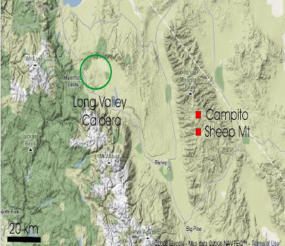
The name of the newspaper caught my eye. Look at the following location map from Eli Rabett: Conrad Black’s Mammoth Lake CA (population 7093) is none other than the Mammoth Lakes CA (Wikipedia population 7093) of the location map, described at Wikipedia as follows: “Mammoth Lakes is located at 37°38′13″N, 118°58′44″W (37.636893, -118.978915), at an elevation of approximately 7900 feet (2400 m). As of the census[2] of 2000, there were 7,093 people, 2,814 households, and 1,516 families residing in the town.”
Maybe they should have characterized the fees as being for not collecting bristlecone pine data. The mind boggles at the possibilities.
The case attracted a lot of attention here because of Black’s using company property as though it were “personal” property. Data, and even correspondence, are also “property”, an issue that I’ll return to on another occasion.
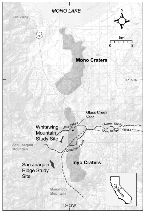
UPDATE: Mammoth Lakes CA is extremely close to the sites studied by Constance Millar in Millar et al 2006 (Whitewing Mt, San Joaquin Ridge) in a study discussed on several occasions e.g. here, here. Millar says:
Preserved vegetation in the Mammoth Lakes – Long Valley Caldera region provides a detailed record of late Holocene climatic, vegetation, and volcanic dynamics. Scattered across the otherwise barren summits of Whitewing Mtn and San Joaquin Ridge, adjacent to and along the Sierra Nevada crest (Fig. 1), are abundant well-preserved deadwood tree stems (Fig. 2).
As noted on prior occasions, they date the destruction of the trees on Whitewing Mtn to “late summer AD1350” and model climate in the MWP as significantly warmer than at present (notwithstanding the Mannian PC1 which records near glacial coldness during this period in California).
Deadwood tree stems scattered above treeline on tephra-covered slopes of Whitewing Mtn (3051 m) and San Joaquin Ridge (3122 m) show evidence of being killed in an eruption from adjacent Glass Creek Vent, Inyo Craters. Using tree-ring methods, we dated deadwood to AD 815–1350 and infer from death dates that the eruption occurred in late summer AD 1350. Based on wood anatomy, we identified deadwood species as Pinus albicaulis, P. monticola, P. lambertiana, P. contorta, P. jeffreyi, and Tsuga mertensiana. Only P. albicaulis grows at these elevations currently; P. lambertiana is not locally native. Using contemporary distributions of the species, we modeled paleoclimate during the time of sympatry to be significantly warmer (+3.2°C annual minimum temperature) and slightly drier (−24 mm annual precipitation) than present, resembling values projected for California in the next 70–100 yr.
Here are location maps synchronizing the location map in Millar et al 2006 with a Google Earth image locating Mammoth Lakes CA on a somewhat similar scale.
|

|


37 Comments
Perhaps APC intended to use its cash to acquire newspapers in other markets.
Mammoth Lakes would also be quite familiar to many from SoCal as well. Strange as it may seem, Mammoth Mountain is thought of as a “Southern California” ski area. That’s because, due to the seasonal pass closures in winter, it takes 8 hours to get there from SF (via Tahoe) whereas it’s only 4 hours from LA.
Long Valley Caldera is a supervolcano.
And you point is?
Do I smell a (Norway) rat?
John A:
Long Valley Caldera is a perhaps active volcano. It is certainly not a supervolcano, for that you need to check out Yellowstone. Right now it is mostly steam vents and mudpots, with an occasional earthquake storm. The earthquake storms are what worry the USGS.
Mammoth Lakes is really lower Central California, and despite its Sierra beauty participates in the culture to the south rather than to the north.
The caldera at least once qualified as a super volcano, as its primary eruption 760,000 years ago ejected something like 600 km^3 of magma. That’s pretty super. Here’s a USGS site that summarizes the geology.
Apparently since 1980, it’s become active again, producing an uplift dome and changes in thermal springs and geysers that imply an impending eruption. Of course, impending in a geological sense could mean any time between now and 1000 years on.
I had the pleasure of meeting the geologist who discovered the caldera. He was in his 80’s, and I met him in the waiting room of an optometrist. I asked him how it came to be, and he said he was on a field trip surveying the eastern Sierras and found that his instruments detected a gravitational anomaly as he traversed what’s now known as the caldera. When I asked him what he did after that, he said he went back to lab and re-calibrated his instruments. Now there’s a good scientist. 🙂
Then I asked him when it’s due to go off. “That’s what we all want to know,” he said.
So, Steve, interesting finale to your story. Do you suppose that the obstructive retention of climate data amounts to criminal theft? Just in theory, I mean. Only in theory. Money was, after all, paid out to acquire the data, but not by those who now keep it hidden away.
I wrote a post previously on the tort of conversion here http://www.climateaudit.org/?p=362 because it was a novel situation that would be an interesting question for a law school examination. See wikipedia as well.
I’ve just returned from an extended vacation out that way. It is truly beautiful country. Among other claims to fame, you have to pass through Mammoth Lakes to reach Devil’s Postpile National Monument (like Devil’s Tower in WY an interesting example of exposed magma columns).
Two thoughts:
The CA state hot creek geological site has been closed to swimming since 2006 because of “increased seismic activity”, but the USGS has stated that we should not take that as an indication that a further eruption is imminent.
Just to the north is North America’s newest mountain range, the Mono Craters. Panum Crater, the newest of those, last erupted about 600 years ago (and the craters on the islands in Mono Lake have had eruptions within the last 300 years).
On the way there, we passed through Tonapah, NV. There is a weather station there which is supposed to monitor radiation blowing from the atomic test sites nearby. It seems to be in a good location for that, but I found myself wondering whether it also is a temperature station as well. It is located in a gravel patch entirely surrounded by an asphalt parking lot.
Such thoughts are just part of the joy of lurking hereabouts. I would not have noticed the station at all before reading this site.
jeez spent most summers of his youth in that part of the Eastern Sierra (and for all you previous ignorant posters, the plural of Sierra is Sierra, not Sierras). I think it is some of my favorite scenery, although Steve, having just been to Banff last week, I have to admit I think you Canadians have the California Sierra beat for some of the most scenic country on the planet.
Steve, looking at your very funny post on the tort of conversion, the very last post says:
And append your post to the request, to stir things up? Should be interesting, and would get kicked straight to their legal department … only if you have time, of course.
My thanks as always to you for the blog, and to the other posters and lurkers as well, stay well,
w.
Stiff sentence! Isn’t six years in Quebec the Canadian equivalent to the death penalty?
I suspect that one the main reasons climate-related research data and analysis information isn’t being handed over is that it simply doesn’t exist anymore. Either it was discarded altogether, purposefully or by happenstance, or else it was modified over time and the chain of predecessor/successor data sets and information stores weren’t maintained.
My past experiences in dealing with research scientists concerning records management issues in government agencies is that many of them have never been exposed to the reality that inadequate record keeping practices have consequences which go far beyond the conduct of the science.
Also from past experience in auditing research scientists, one can deduce from various patterns of behavior that some research scientists abuse their position of public trust by operating under the assumption that no one will ever bother to take a close look at the details of how they produced their work, or will challenge the quality of their work solely on the basis that processes and procedures were blatantly and consciously ignored.
Dr. Rabett’s post at http://rabett.blogspot.com/2008/03/gassing-it-up-eli-has-had-idle-thought.html is in fact very interesting. It turns out that the Long Valley Caldera indicated has been exhaling huge quantities of CO2 — perhaps enough to cause an exceptional growth surge downwind at Sheep Mountain?
Someone should measure the current CO2 levels across the valley and at Sheep Mountain.
I don’t see how Conrad Black fits into this yet, but I look forward to learning. Judge Richard Posner, BTW, is highly regarded by many economists for his “Law and Economics” approach, whence his joint blog with Chicago economist Gary Becker.
(I’ve been on the road and teaching this summer, so I haven’t been as active here as I’d like.)
#14, Hu, I think that the possible CO2 fertilization issue at Sheep Mt is a bit of a red herring. The much more fundamental issue is the replicability of Graybill’s chronology at Sheep Mountain, where Linah Ababneh did not replicate Graybill’s results – there are a number of posts on this last fall.
Both Pete Holzmann and I think that the mechanical formation of strip bark can have a profound impact on a ring width chronology. A strip bark pulse looks like it can cause a 6-7 sigma excursion in ring widths as they appear in a core for over a century. If you have any ideas on how to implement an error model, I’m all ears. But the more practical conclusion is that strip bark trees should be avoided altogether – the recommendation made by the NAS panel, though their reasoning was not surgical.
Graybill said that he preferentially selected strip bark trees. In a small sample, such as Graybill, having even a few extra strip bark cores in their excursion phase, could cause a HS shape all by itself. Graybill’s archive is also incomplete – Pete H located tagged samples that never appeared in the final archive.
If one uses Ababneh’s chronology at Sheep Mt, the HS disappears without worrying. At Almagre and other sites, recent growth has not been exceptional. So CO2 fertilization is not something that I presently believe to be nearly as relevant as biased selection and the mechanical impact of strip bark formation.
I’ve made an addition to this post, showing that the study area in Millar et al 2006, discussed on a number of occasions on this site, is just to the north of Mammoth Lakes CA, which is mentioned in the article. They report that the subfossil trees high on Whitewing MT were killed in late summer AD1350 by volcanic activity. As noted on earlier occasions, their ecological model concluded that MWP California was substantially warmer than at present. The inconsistency between their ecological evidence and Mann’s PC1, interpreted as showing near glacial coldness in this period, is something that a professional organization would be required to reconcile, but continues to be ignored by IPCC and the Team.
As a reviewer of IPCC AR4, I asked that Millar et al 2006 be discussed. They refused.
Rabbett’s whole posting is just wrong in so many ways. I posted some questions on his site regarding mistatements (below) and never got a response or correction.
Me?? Why would you expect me to be able to clarify something from Rabett’s fevered imagination? I have no idea what the purpose of his posting was. However, the locale is one that interests us and I thought that it was amusing that Conrad Black’s Mammoth Lakes turns up on some of the location maps.
# 18 Sorry for any confusion. The last three paragraphs in # 17 were what I posted on Rabett’s site regarding his comments on Long Valley caldera.
re 18. rabbet… fever.. hehe. thas a good one
The point came from reading some papers on old trees in the Sierra. You have to wonder why trees survived for such a long time in what is not an ideal environment wrt precipitation and other things. It occurred to Eli that CO2 fertilization might account for some of this because of an intense nearby source. The papers assume that CO2 concentrations at Sheep Mountain, etc. follow the global trend. Lithophysa1 had some good points and I really did not follow up, but we do know that air packets high in CO2 can travel long distances, etc.
Eli is never, ever wrong. To simply say that “Lithophysa1 had some good points” hardly acknowledges Rabbett’s gross errors.
Eli @ #21
Do you have any references for your statement “we do know that air packets high in CO2 can travel long distances”? I couldn’t find any. Or were you just Joshing? 😉
oblate spheroid eli
Rattus:
No, I didn’t have a point other than to mention that Long Valley Caldera is a supervolcano. And it is, being a depression in the ground rather than the classic cylindrical cone of more modest volcanoes. It’s not as big as the Yellowstone supervolcano, but that’s what it is all the same.
By the way, if memory serves, the cones at Inyo last erupted around 600CE.
I doubt very much that carbon dioxide itself could have caused the sudden growth of the White MOuntain bristlecones, but my suspicion is that if the soils were enriched by a volcanic eruption or by a lake bed drying out and being blown over the White Mountain area, we might see some spectacular growth in the bristlecones which generally grow in very poor soils.
#25. As I’ve said on many occasions, the “spectacular growth” in Graybill’s chronologies was not replicated by Ababneh and may well be an artifact. So it’s completely premature to think of theories until the chronology can be replicated.
With Black off the Sun-Times board for 2 years now and safely in prison, Sun-Times shareholders must welcome the company’s turnaround under new management.
Uhm.
For a very different take on the Conrad Black case, readers will enjoy Conrad’s friend Mark Steyn’s contemporaneous coverage for Macleans of the original trial, from opening arguments through the final verdict. Features sharp portraits of the participants, and a spirited and entertaining defense of Conrad. Not to be missed, but you’ll have to start at the last page and work your way forward in time:
http://forums.macleans.ca/advansis/?mod=for&act=dis&eid=52
Steve, #26, writes
You’re undoubtedly right that the Sheep Mtn. HS is just a stripbark growth surge effect, as evidenced by Ababneh’s suppressed replication effort.
However, the burden of proof is on Mann et al to demonstrate that all their ceterises were really paribus, including local CO2 and volcanic ash fertilization, if potentially relevant. Halpern (aka “Eli”) therefore is to be thanked for calling attention to yet another crack in the stick.
I frequently backpack in this area and the only CO2/Tree related episode in the last 20 years was a pulse of CO2 that killed several thousand trees:
http://lvo.wr.usgs.gov/CO2.html
Here is a map of the CO2 emission sites around Mammoth.
Watch where you go snow mobiling around there!
As I remember it a graph of the temp reconstruction derived from Millar et al was itself a hockeystick ending in 1350. Is it an intrinsic property of tree ring cores, that as they approach the outer bark, the rings are fatter and are then interpreted as higher temps in the present?
I will bet you that stripping is synchronized among stems, does not occur randomly through time.
No. Typically, it’s the opposite. (Hence the common use of the negative exponential detrending spline.) However, in the special case of stripbark bcps, well, read my previous comment. Whether you get a fattened outer set of rings depends on (1) when you sample relative to the time of stripping and (2) whether or not you get your corer into the fattest part of the growth rebound. Recall not all cross-sections have the same degree of rebound.
That was our impression tho it would take more info to establish this. The “loudest” event in the Almagre chronology was the extreme low growth in the 1840s and impressionistically some strip bark pulses seem to originate around that period, Pete thought that extreme snow could led to strip formation by breaking off branches – he noticed some wounds in progress as some branches were tearing bark off as they fell down. Ironically, the growth pulse would be a reaction to the 1840s. Recall that Mann’s bizarre “CO2” adjustment was mainly to late 19th century growth. On this scenario, the extreme 1840s caused a non-random time distribution of strip barking.
Dessication, winter or summer, could lead to partial cambium dieback. Is stripping more common on the windward, southern-exposed side?
We have metadata for each observed Almagre tree showing which side(s) is/are stripped, and the ground slope for each. Presumably that could be parsed to determine any correlation with prevailing winds.
The hard part in the mountains is that it may be less clear what is the windward side of a tree. You may have to further analyze neighboring slopes, nearby tree cover, etc.
In addition to wind & sun exposure, I wonder about snow albedo and abrasion (loose pumice soils in summer and/or ice crystals in winter). Any thoughts there? Also: is the “strippiest” side of the tree not obvious from external inspection? And if so, does this vary among trees within a locale?