CRU Reveals Station Identities

Willis Eschenbach received a message today that the CRU list of stations used is online at http://www.cru.uea.ac.uk/cru/data/landstations/ . The webpage says:

The file gives the locations and names of the 4138 stations used at some time (i.e. in the gridding that is used to produce CRUTEM3) during the period from 1851 to 2006. All these stations have adequate 30 year averages for 1961-90 as defined in Brohan et al. (2006). The 4138 total is lower than the 4349 value given as the starting point for Brohan et al. (2006) and used in the latest IPCC Report. A small number of stations have been removed during Brohan et al. (2006) because of the presence of duplicate data and insufficient coverage for the period 1961-90.

They say:

The numbers we use are listed in numerical order up to station number 988360. Up to this point, the numbers ending in zeroes are generally the WMO number (*10) in use for that station in the mid-1980s. Numbers not ending in a zero have generally been assigned by CRU or may have originated from other sources. Stations that are listed after number 988360 are stations for which CRU has assigned numbers, mostly beginning with 72 (so using spare country numbers not officially used by WMO) to 75 (corresponding to stations in the United States). Some WMO IDs have been updated in the 2000s.

It looks like the sixth digit is the GHCN identification. This seems to be the case with Marysville which I checked. They note:

The station temperature data are updated each month, together with some back data for the last couple of years. As the WMO IDs have not all been updated, we have a look-up Table which associates some current WMO station numbers with the earlier values we are using. Updates come from two principal sources [CLIMAT messages exchanged between National Meteorological Services (NMSs) and from the publication Monthly Climatic Data for the World]. Additional updates in near-real time (either monthly or annually) come directly from Australia, Canada, New Zealand, Austria, the Nordic countries and a few others.

The look-up table doesn’t seem to be online.

Some aspects of HadCRU3 are easier to implement than GISS – earlier this year, I was able to track a gridcell series to the Barabinsk station data. With Hansen, you can never track anything. There’s a case for putting some of the Hansen mysteries on hiatus for a while and digging into CRU. The effort in understanding the individual stations is not lost since we’re mostly dealing with GHCN and MCDW data.

Dongge Cave

Dongge Cave is a very long speleothem in southeast China, which is held to provide evidence on changes in the Asian monsoon.

It was most recently considered in Bao Yang et al (QSR 2007) in juxtaposition with the Dasuopu ice core, Oman speleothem S3 and the RC2730 Arabian Sea core showing G bulloides percentage. (This latter core was an important contributor to the Moberg reconstruction and has been discussed on several occasions – G bulloides are evidence for cold water and are interpreted as evidence of increased upwelling of cold water, which in turn is considered to be evidence of wind speed, and thus monsoon activity.)

Kim Cobb has also just reported a new speleothem in Borneo, somewhat the same part of the world, which I’ll try to look at soon. I’ve not previously looked at the Dongge Cave speleothem. Its results have been properly archived at WDCP, much facilitating examination. Continue reading

A Second Look at USHCN Classification #2

Continuation

Unthreaded #21

No discussion of CO2 measurements, thermodynamics, theory of radiation, etc. please – other than to identify interesting references – and something more than the title is usually helpful. How hard can that be? If anyone can identify a clear exposition of how 2xCO2 leads to 2.5 deg C, please do so. (I’m not taking any position on the matter, I’m just trying to identify the best possible exposition. )

Russian Bias

There has been much discussion on this site regarding the methodology employed by Dr. Hansen’s “Step 1”, also known as the “bias method” in HL87. Readers unfamiliar with the topic may want to read through the material here, here, and here to gain a better understanding of the method and issues raised with employing it.

What was clear since we first unraveled the process was that it was destined to corrupt the combined station data and, as it’s name implies, add a bias to that combined data. What was not clear was what the net effect would be to the regional and worldwide temperature record.

Thanks to Steve’s help, I recently completed an initial look into the effect the bias method has on the temperature record.

Continue reading

YTD Hurricane Activity

Some of you have been noticing a tendency for almost any gust of wind in the Atlantic to now become a named storm. Given this tendency, more relevant metrics are obviously the number of hurricane-days (and the closely related ACE index) and the number of storm-days.

I’ve scraped the data and done the YTD calculations, comparing these to the corresponding values to the end of September in previous years (I’ll replace this graphic in a few days when Sept 2007 is completed, but I don’t expect much change.) Continue reading

Houston, We've Found Wellington NZ

As noted before, climateaudit readers have helped UCAR find the lost civilization of Chile and today, we are happy to report that we have helped NASA find the lost city of Wellington NZ.

NASA’s records for Wellington NZ were mysteriously interrupted in 1988 – an interruption so severe that we assumed that Wellington NZ must have been destroyed by Scythians. We are happy to report that Wellington NZ is still in existence.

This is not the only good news. We are also happy to announce that there is still a functioning meteorological service. Not only that, but can announce contact with the indigenous representatives.

Although NASA (and NOAA) appear to have lost contact, an indigenous NZ climate scientist familiar with the lost records has contacted climateaudit. I have passed this exciting news on to NASA and urged them to restore contact with their lost cousins in NZ. Continue reading

TOBS

It’s true that TOB is pretty far from the topic of this thread, so perhaps our host could start a new one just on TOB, ideally copying into it the pertinent posts from this thread? I may have missed a few, but a good start would be #305, 376, 400, 402, 403, 413, 418, 419, 420, 424, 455, 458, 460, 462, 464, 468, 484, 488, and 493. )

Hugues Goosse and the Unresponsiveness of Juckes

On Sep 21, 2007, Hugues Goosse, the Climate of the Past editor responsible for the Juckes article, published a statement saying that a revised version of the Juckes et al article had been submitted to “conventional” refereeing and accepted on Sept 21, 2007. He said:

On the other hand, the authors disagree with one reviewer on some points for which no clear consensus could be gained from published literature. The arguments of the authors appear reasonable from our present knowledge of the field and are presented in a balanced way. As a consequence, I decided to accept the paper for publication in Climate of the Past.

I presume that I was the “one reviewer”, although Willis Eschenbach and Mark Rostron also submitted critical reviews. Under CP policies, authors are supposed to respond to review comments. I’ve collated my review comments together with Juckes’ replies. It is remarkable how insolent and unresponsive Juckes’ comments are.

In virtually every case, I’ve provided a detailed and analytical comment and Juckes virtually never makes a direct and straightforward reply, rebutting the comment in straightforward terms. See what you think. Continue reading

Hansen Step 2 – First Thoughts

The source code for Hansen’s Step 2- the “urban adjustment” step is online. If anyone’s been able to operate the program through to Step 2, I’d be interested in some stage results for the stations discussed here. The verbal description is not clear and the code is a blizzard of old-fashioned Fortran subscripts, so it will take a little while to translate the procedure into modern languages and see what he’s doing.

Hansen et al 1999 says:

An adjusted urban record is defined only if there are at least three rural neighbors for at least two thirds of the period being adjusted. All rural stations within 1000 km are used to calculate the adjustment, with a weight that decreases linearly to zero at distance 1000 km.

In the stations that I’ve looked at, I’ve seen adjusted stations being calculated when the above condition doesn’t seem to hold. So any light that can be shed on the procedures would be appreciated.

Stations within 1000 km
The first step in Hansen’s Step 2 is the calculation of rural stations within 1000 km of an urban station to be adjusted. The archived script shows that this calculation is done from scratch in each run. No particular harm in that although the information presumably remains the same in every run. I’ve compiled the list of “Hansen-rural” stations for each of the 7364 stations, including in each list the id, name, lat, long, start_raw, end_raw, start_adj, end_adj, distance (from target), GISS-population, GISS-urban and GISS-lights. I archived the result at http://data.climateaudit.org/data/giss/stat_dist.tab . The information is a bit redundant to the station information lists but it was handy having some of the information directly accessible to aid analysis. The object is 33MB . The script to do this is at http://data.climateaudit.org/scripts/station/hansen/step2A.txt

In order to analyze Hansen’s actual urban adjustment mechanism, it’s nice to identify the stations with only a few contributing rural stations. There’s a very pretty R function that can do this in one line. The object containing the information stat_dist.tab is structured as a list in R with 7364 items, one for each GISS station. Each item is an R data-frame – which is structured as a matrix but the columns can be of different types. A very handy thing to be able to use. To obtain the number of rows for the 1000th station in the list, you can use the command

nrow(stat_dist[[1000]]) #86

To obtain the number of rows for all 7364 stations, all you need to do to get a vector is:

stat.length=sapply(stat_dist,nrow)

Just like magic. No blizzard of Fortran subscripts and 5 pages and programming.

Now to locate stations with only a few contributing rural stations for analysis purposes, you can do the following (I’ve already got my GISS information http://data.climateaudit.org/data/station/giss/giss.info.dat loaded as stations.tab

temp=(stat.length<3) ; index=(1:7364)[temp]
temp_urban=(stations$urban==”U”)
stations[temp&temp_urban,1:10]

This yields the following list of sites, all in India:

country id name lat long altitude alt.interp urban pop topo
1180 207 20742867000 NAGPUR SONEGA 21.1 79.05 310 302 U 930 HI
1188 207 20743128000 BEGAMPET 17.5 78.50 545 550 U 1796 HI
1190 207 20743185000 MACHILIPATNAM 16.2 81.15 3 30 U 113 FL

In these three cases, I checked and there was no “adjusted” series for any of the 3 sites, which, in this case, complies with the Hansen et al 1999 3-rural station criterion. I then checked “U” sites with 3 neighbors, all in India, Brazil and New Zealand and again didn’t obtain any adjusted series.

index=(1:7364)[temp_urban& (stat.length==3)];stations[index,1:10]

country id name lat long altitude alt.interp urban pop
1189 207 20743149000 CWC VISHAKHAP 17.70 83.30 66 142 U 353
2054 303 30382599000 NATAL AEROPOR -5.92 -35.25 52 12 U 377
2062 303 30382900000 RECIFE -8.05 -34.92 7 18 U 1184
2088 303 30383781000 SAO PAULO -23.50 -46.62 792 883 U 7034
6011 507 50793116001 AUCKLAND -36.90 174.80 5 9 U 145
6012 507 50793116002 ALBERT PARK -36.85 174.77 49 4 U 145
6013 507 50793116003 AUCKLAND, ALBERT PARK -36.85 174.77 49 4 U 145
6014 507 50793119000 AUCKLAND AIRP -37.02 174.80 6 17 U 145
6024 507 50793890001 DUNEDIN AERODROME -45.93 170.20 1 151 U 77
6025 507 50793893001 DUNEDIN MUSSELBURGH NEW ZE -45.90 170.50 2 190 U 77

I then experimented with sites classified as “small” and got some puzzles as shown below.

index=(1:7364)[temp_small& (stat.length==3)];stations[index,1:10]

country id name lat long altitude alt.interp urban pop topo
312 125 12567197000 FORT-DAUPHIN -25.03 46.95 9 100 S 14 HI
1185 207 20743041000 JAGDALPUR 19.08 82.03 553 512 S 47 HI
1855 224 22443436000 BATTICALOA 7.72 81.70 12 8 S 42 FL
1861 224 22443497000 HAMBANTOTA 6.12 81.13 20 42 S 11 FL
6023 507 50793844000 INVERCARGILL -46.70 168.55 4 28 S 49 FL

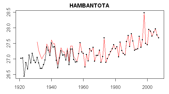
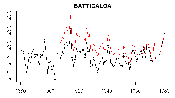
For the first two sites, there was no adjusted series, but for the 3-5 series there were adjusted series. Batticaloa and Hambantota are very close and it turns out that their 3 R neighbors are identical. So based on the apparent Hansen adjustment process in which the urban station trends are supposedly coerced to the rural reference stations, one would expect similar adjusted trends. This proves not to be the case. Why – I’m not sure right now and would welcome any thoughts.

The three rural stations for Batticaloa and Hambantota are shown below – note that the distances from the two urban sites to the three rural comparanda are similar and in the same order.

id name long lat start_raw end_raw start_adj end_adj dist pop urban lights
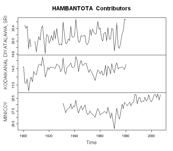
1859 22443476001 DIYATALAWA, SRI 81.00 6.80 1901 1980.917 1901 1980.917 128.2031 NA R A
1200 20743339000 KODAIKANAL 77.47 10.23 1900 1980.917 1900 1980.917 542.0993 NA R A
1203 20743369000 MINICOY 73.15 8.30 1931 2007.917 1931 2007.917 943.8923 NA R A

id name long lat start_raw end_raw start_adj end_adj dist pop urban lights
1859 22443476001 DIYATALAWA, SRI 81.00 6.80 1901 1980.917 1901 1980.917 76.9864 NA R A
1200 20743339000 KODAIKANAL 77.47 10.23 1900 1980.917 1900 1980.917 609.3207 NA R A
1203 20743369000 MINICOY 73.15 8.30 1931 2007.917 1931 2007.917 913.2765 NA R A

The figure below shows the annual temperature values of the three rural stations. Two of them end in 1980 and only one (Minicoy) continues to the present). I test the proportion of years with at least 3 stations to the number of years of adjusted record and found that 2 of the 3 series failed the test. So it would be interesting to locate exactly where Hansen implements the 2/3 criterion in his code. I haven’t been able to do so yet. One also sees that, in this case, much depends on the Minicoy station as the only one continuing to the present.

wellin59.gif

Now for today’s puzzle – showing the dset=1 and adjusted versions of Hambantota and Batticola. How does Hansen get such different looking adjustments from identical rural comparanda? If anyone can do runs of the actual code for these stations and save any intermediate work, it would help. (Also Wellington NZ).

wellin58.gif

wellin60.gif