Eli Rabett's Bait and Switch

Eli Rabett, a pseudonymous professor and blogger, fresh from simply inventing tittle-tattle about me (his fabricated story that my downloading of GISS data had “resulted in denial of service to everyone else”), has continued his descent with a bait-and-switch illustration of the supposed “Boulder station” in an effort to discredit the collection of microsite data by Anthony Watts and others. Rabett shows a picture of a site that seemingly meets all sensible standards of what a site should be. The trouble is that this site is neither the USHCN Boulder site, nor does it belong to the USHCN system. Indeed, it’s only been in operation since 2003. Continue reading

surfacestations.org

Anthony Watts announces the start-up of surfacestations.org, an effort to catalogue microsite information for weather stations used in the construction of surface temperature histories, an effort that is obviously highly worthwhile. Anthony:

As many of you know from watching blog postings here, I have made it my mission to photograph, survey, and catalog every USHCN station for the purposes of doing a qualitative analysis on the near surface temperature data produced by the USHCN dataset.

To that end, I have created http://www.surfacestations.org which links to a separate photographic database server that I have set up. It was designed from the start to be collaborative.

Therefore I’m writing today to ask your assistance in this project.

What are the goals?

To provide a standardized method for site survey and reporting so that interested individuals can gather site survey data, pictures, and anecdotal history of climate recording sites worldwide, and upload to a publicly searchable photographic database
To provide a repository for screened and approved qualitative and quantitative site survey data, pictures, and anecdotal history
To provide a publicly searchable database of such information for USHCN and GHCN climate station sites
To photographically document sites that have been well preserved and maintained through their history
To photographically demonstrate examples of sites that may introduce biases and errors through faulty siting, encroachments, or maintenance issues, and to identify specific issues when possible

The photographic database server has been setup and running successfully for about 10 days now, and between myself and my associate Russ Steele, we have managed to survey, photograph, and upload a number of USHCN stations in California. Feel free to visit and browse the online database to locate those California stations to see what we’ve found so far.

I have plans also to include the GHCN dataset and various GISS stations that are not part of the USHCN set. But given the sheer volume of that task, I’m deferring that until I can complete a database import mechanism. For now lets concentrate on USHCN.

Its easy to assist in this project – it also makes great adventure detour for summer vacations

If you’d like to survey photograph and photograph a USHCN station near you its just a few simple steps.

Locate the USHCN stations near you, a list is posted by state on http://www.surfacestations.org on the online photographic database server. You can also visit http://www.surfacestations.org/USHCN_stationlist.htm and select from the list there.

Download the “how to guide” and the blank “station survey” form from http://www.surfacestations.org
Follow the instructions in the “how to guide”, some sluething may be required to locate the USHCN station, your local state climatologist may be able to help
Photograph and survey the station, including getting a GPS fix.
Fill in the blanks in the site survey form, and prepare your pictures for upload.
Register your email account at http://www.surfacestations.org, then locate the station placeholder. If the station placeholder does not yet exist contact my assistant Jenni, jenni@itworks.com and she’ll setup a blank placeholder album for you.
Upload your pictures and site survey to the USHCN album with the name of the station you surveyed.
We will be actively creating new station placeholders for you to upload your results to this week. For now, there’s plenty of time to go have a fun an informative adventure in tracking down all the 1221 USHCN weather stations and getting them surveyed.

Happy hunting!

Anthony Watts
awatts at itworks.com

Unthreaded #12

Continuation of Unthreaded #11

Why does CRU have a confidentiality agreement with Germany?

Today we ponder why many National Meteorological Services (NMSs), including the NMS of Germany, have provided data to CRU under confidentiality agreements which supposedly prevent Phil Jones from disclosing the identity of these stations. Continue reading

Tom Karl’s Station Adjustments

The USHCN Station History Adjustment procedure is credited to Tom Karl in Karl and Williams 1987. Karl has been very prominent in the IPCC movement. That’s not to say that the potential adjustment is wrong or unjustified, but that the adjustment needs to be scrutinized with the same care as one would scrutinize an adjustment by, say, Briffa, Jones or Mann.

Towards the end of Karl and Williams 1987, he says:

“Stations with nonclimatic progressive changes due to urbanization may lead to inappropriate adjustments at nearby stations… This latter problem is mitigated to some extent in the HCN since 70% of the stations have populations less than 10,000 in the 1980 census and 90% have populations less than 50,000.”

Here’s the full excerpt together with a discussion of IPCC AR4 consideration of the topic, Continue reading

Some Northern California Station Plots

I’ve plotted up some USHCN station information for the 18 sites closest to Susanville (why Susanville – it’s one of the Anthony Watts- Russ Steele sites that they happened to post on lately.) I’ve been reading Karl and Williams 1987 which sort of describes the USHCN Station History Adjustment method. I’ll talk about Karl and Williams 1987 on another occasion – it deserves a very close reading as its adjustments are embedded in all the present gridcell calculations. Karl and Williams say that they consider the 20 nearest stations in their Station History Adjustment. I plotted 18 to fit in 3 columns and the graphics are already very cramped. I’ll show 3 of the 7 versions below:
1) the USHCN “raw” (Areal) version
2) the GISS adjusted version
3) the USHCN time-of-observation adjusted version. This is the most lightly adjusted method and there is a valid argument for a time-of-observation adjustment. But the Team tends to show this relatively well-argued and documented adjustment and then lever a lot of other adjustments on the back of this. Continue reading

Mann's New Divergence "Theory": A Smoothing Artifact

Over at realclimate, Mann has advocated a new “explanation” of the Divergence Problem raised by one of their readers in connection with IPCC AR4 Figure 6.10. Mann says that there is no Divergence Problem; he blames the reader for failing understand boundary constraints in smoothed series. Raising the Divergence Problem at realclimate was so blasphemous that either Mann or his website hosts, Environmental Media Services, investigated the IP address of the person who dared to ask about the Divergence Problem. The Divergence Problem is however a real issue and not simply an artifact of IPCC smoothing.
Continue reading

Server upgrade is coming soon

Due to the loading on the current dedicated server causing regular server crashes, I have decided to move CA and other hosted blogs to a new server with twice as much memory (2GB) and utilizing a proper server-oriented Linux rather than using a general purpose Linux. It demonstrates that if you’re going to do serious hosting, then you need to plan ahead rather than hope that your current benchtest system will do the job – it will, but not reliably long term.

At the moment, I am trying to decide between CentOS5 or SuSE Linux Enterprise Server.

What this will mean is that sometime in the next 2 weeks, CA will go offline for a few hours while the DNS updates around the world. I will let everyone know closer to the time when this is likely to occur.

Adjusting for the "Rural Cooling Effect"

I spent quite a bit of time today ploughing through USHCN station data, doing a lot of grunt work. For example, I spent time aking a concordance of 1221 USHCN identification numbers with GHCN id numbers (they aren’t the same) and I haven’t seen a concordance anywhere. Most of it could be done through matching lat-long neighborhoods and common name starts. I got all but 3 matched through 3 fairly ad hoc rules. It was actually easier than the smaller Jones China concordance because the latitudes and longitudes were all correct or correct within a very close rounding error. One of the reasons for doing this is that Hansen et al have arrchived their lights value for GHCN id #, but not for USHCN id #. I’ve collated a data file for all USHCN stations which also looks up the GHCN metadata: lights, vegetation, topography. They have a lot of codes and metadata, but they don’t appear to have a code for parking lot or for whether an electric light is in the box with the thermometer. The data file is here.

In the Hansen temperature calculation, he says that the long-term trends are defined by “rural” stations, defined in Hansen et al as having lights=0 according to their brightness index. Having collated the lights information with USHCN identifications, I then extracted the California stations with lights=0.. Details (excerpted from the larger file above) are here. There were 17 such stations, a couple of which we’ve discussed over the past few days, courtesy of Anthony Watts: BRAWLEY 2SW, CEDARVILLE, CUYAMACA , DEATH VALLEY, ELECTRA PH, FAIRMONT, FORT BRAGG 5N, HAPPY CAMP RS, INDEPENDENCE, LAKE SPAULDING, LEMON COVE, NEEDLES FAA AP, ORLEANS, SUSANVILLE AP, TEJON RANCHO, WILLOWS 6W, YOSEMITE PARK HEADQUARTERS.

Lake Spaulding is one of the 17. It’s the one with the weather station attached to the boat in the parking lot. It turns out that until recently there was a much better location for the station, but it was recently changed to a site that is worthless. One wonders why IPCC has never stated that sites like the old Lake Spaulding are valuable for long-term weather keeping and at the total mismangement of the system in which Jones and Hansen have failed to oppose such changes.

I’ve collated 7 different versions for each site: the three USHCN versions (areal, time-of-obs adjusted, filnet (Which is mainly Karl’s Station History Adjustment), 2 GISS versions: raw and adjusted and two GHCN versions: raw and adjusted. By and large the threefold adjusted USHCN version is approximately the GISS raw version. In each case, I plotted out the impact of the various adjustments from USHCN raw to GISS “raw” to GISS adjusted.

A few patterns seem to emerge. First, in the majority of these “best” sites, there is a warm 1930s. The net impact of the several adjustment stages is to reduce the 1930s relative to the end of the 20th century. Probably the largest contributor to this was the USHCN Station History Adjustment, which is done according to a procedure of Karl and Williams 1987. (Karl, T. R., and C. N. Williams, Jr. 1987. An approach to adjusting climatological time series for discontinuous inhomogeneities. Journal of Climate and Applied Meteorology 26:1744-1763. http://ams.allenpress.com/archive/1520-0450/26/12/pdf/i1520-0450-26-12-1744.pdf) Whatever the “good” reason for this adjustment, the main practical effect seems to be the lowering of past high temperatures. It also seemed that GISS was very likely to exclude past high temperatures from their collation, but were like a dog on a bone for past low temperatures. I’ll show one station to give a flavor of what I was doing.

Cedarville
The first plot is a simple spaghetti graph of the 7 different annualized versions as shown below, showing warm 1930s in this case.

cedara49.gif
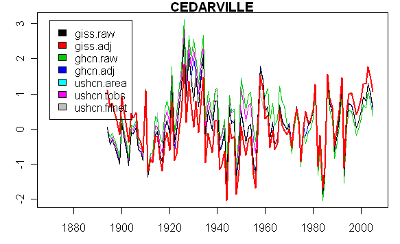
Figure 1. Spaghetti graph of 7 versions of station history (1961-1990 anomaly basis)

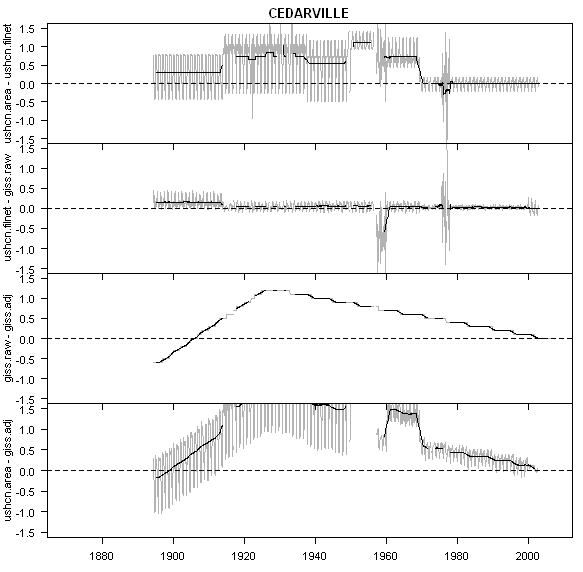
The next is a plot showing 3 stages from USHCN raw to GISS adjusted: from USHCN raw t0 USHCN filnet (adjusted); from USHCN filnet to GISS raw (these tend to be very close) and from GISS raw to GISS adjusted. In this case, the USHCN adjustments collectively increased the trend by about 1 deg C and the GISS adjustments another 1 deg C.

cedara50.gif

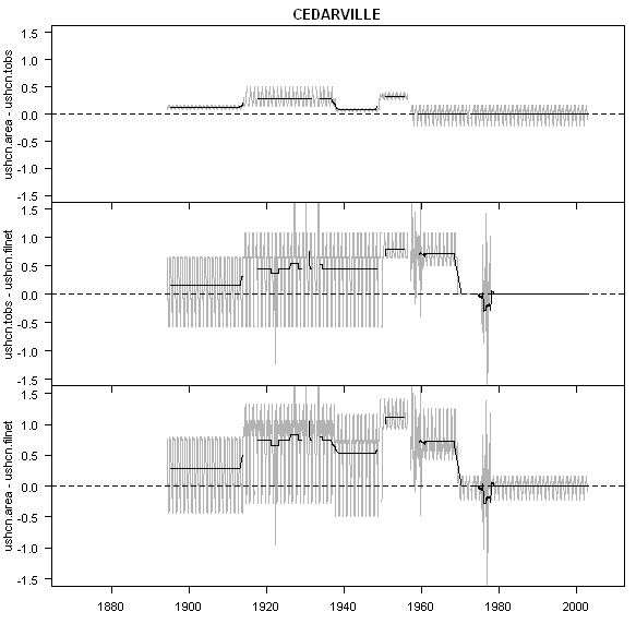
The next figure disentangles the USHCN adjustments by type. The time-of-observation adjustment makes little difference, but the Station History Adjustment makes a large difference.

cedara51.gif

USHCN station history information is described here , while the station histories are at http://cdiac.ornl.gov/ftp/ushcn_monthly/station_history . This file is extremely hard to read as it uses lots of indicators in Fortran punch card format.

begin_date dist_prev_loc conf_dist_move dir_move elev_chg hgt_chg CRS DT MN MX MMTS
05 01 1894 NA 0 999 NA NA 1 0 1 1 0
02 01 1914 0 0 0 0 0 1 0 1 1 0
10 01 1937 0 0 0 0 0 1 0 1 1 0
04 28 1938 0 0 0 0 0 1 0 1 1 0
03 01 1949 0 0 0 0 0 1 0 1 1 0
04 01 1950 0 0 NNE 0 -2 1 0 1 1 0
04 20 1957 0.1 0 S -3 2 1 0 1 1 0
02 12 1959 0.2 0 N 0 0 1 0 1 1 0
03 20 1960 0 0 NW -2 0 1 0 1 1 0
07 24 1969 0.2 0 NNW 0 0 1 0 1 1 0
08 16 1974 0 0 0 0 0 1 0 1 1 0
09 12 1975 0 0 E 0 0 1 0 1 1 0
11 02 1977 0 0 W 0 0 1 0 1 1 0

More ISO-2000 Weather Stations from Jones and Hansen

Anthony Watts writes:

I decided I’d drop some more fun with entropy your way. Here is the USHCN station in Redding, CA # 425725920010 now operated by the US Forest Service at their HQ located at the Redding Airport it used to be operated by the NWS, but that WSFO closed in the mid 90’s.

Like Marysville, the site is surrounded by asphalt, and the surface is unnatural – its wood chips over weedmat, and I’ll have to say it was hot as hot to walk on.

But the kicker is the “accessories” they’ve added for convenience of running the hygrometer and for night observations. Yes is another fine high-quality USHCN site. I winder how many times they forgot to turn off the light? Its a 65 watt bulb by the way.

Continue reading