Hansen and Schmidt: Predicting the Past?

I meant to write about this particular smoking gun some time ago, but I didn’t want to take away attention from Steve’s travails with the NAS Panel and with Geophysical Research Letters. Willis Eschenbach did the actual replication so really it’s his story.

If you cast your minds back to last year, a modelling study[1] by James Hansen and Gavin Schmidt was touted as yet another "smoking gun" proving that the dire warnings of future warming were justified as they could now model the past – or at least a few years of it.
Continue reading

Daily Telegraph

A nice favorable mention today in an article by Bob Carter in the Daily Telegraph today.

Bob Carter is an Australian geologist, who has carried out extremely interesting analyses of clnmate variability over the past 3.6 million years. I showed one of his graphs here -scroll to the bottom.

This is not an entirely unbiased article, as Bob was the first person to encourage me to pursue research in this area back in mid-2003 when no one had ever heard of me, I’d never written an accademic article and was just musing on the internet. He emailed me to say that I was looking at proxy issues in a different way than anyone else and that what I was doing was worthwhile. We’re about the same age, I’ve met him in San Francisco at both AGU conferences that I’ve been at and we get along famously.

A Weird Jacoby-D'Arrigo Series

I mentioned a couple of days ago that Schweingruber et al [1993] seems to arrive at opposite conclusions to Jacoby and D’Arrigo [1989] as to whether anomalous post-1950 ring widths occur (let alone whether that is due to CO2 fertilization or temperature.) It was interesting to compare Schweingruber-Kienast results at Niwot Ridge. It turns out that Schweingruber has published results (cana060) for Churchill, Manitoba, an important site (cana158) in Jacoby and D’Arrigo [1989] (and several other Jacoby-D’Arrigo publications.) Here’s what it looks like – a typical Jacoby elevated 20th century, but inconsistent with Kienast and Luxmoore or Schweingruber et al 1993.


Figure 1. Jacoby-D’Arrigo chronology for Churchill MB (cana158)

Before showing the results, I’ll mention that I corresponded in early 2004 with D’Arrigo about this data set. MBH98 said that they had carried out certain quality control procedures for tree ring data sets to verify minimum correlations between the measurement data and WDCP crn series. I checked this for over 300 sites and one site that really stuck out as having a low correlation between the measurement and crn series was cana158 (it was about 0.05 by memory, as compared to a MBH minimum of 0.5, again by memory). In addition, the crn series went to 1982, while the measurement data only went to 1978, so there was some inconsistency between the data (as well as evidence that MBH had not carried out the quality control that they said that they had carried out.)

I wrote to D’Arrigo about this inconsistency and she said that the series should be withdrawn (although it’s used over and over). I re-checked a few days ago and the crn series is still at WDCP unamended. Anyway, after noticing the remarkable differences between Keinast and Luxmoore [1988] and Schweingruber et al [1993] on the one hand and Jacoby and D’Arrigo [1989] on the other, I’m now intriguing by any chances for detailed cross-checking. Figure 2 below shows two comparisons of the Jacoby-D’Arrigo chronology for Churchill MB – on the top against my emulation of the chronology calculation using STD methods and archived measurement data; on the bottom against the Schweingruber chronology for a sample in the same area (indeed Jacoby and D’Arrigo use Schweingruber’s MXD results from this sample). Both are materially different from the Jacoby-D’Arrigo chronology, especially in the 20th century.


Figure 1. Jacoby-D’Arrigo chronology for Churchill MB (cana158) Top: black – Jacoby chronology (cana158); blue – std emulation; Bottom – black – Jacoby chronology cana 158; red – Schweingruber chronology cana060.

I’m becoming pretty baffled by what’s going in tree ring world. I checked the identification numbers for the two different data sets. Schweingruber had identification numbers up to 19, but reported only 12 trees (missing 5,12-14, 16-18). He reported 24 cores – 2 consistently for each tree. Jacoby and D’Arrigo had identification numbers up 15, but reported only 9 trees (missing 2, 5-6, 8,11-12). They reported 4 cores for one tree (#7), 3 cores for one tree (#1); showed core id numbers reaching 3 for 2 trees where only 2 cores were reported (#9, #10); reported 2 cores for 3 trees with 2 being the highest core id# (#3, 14, 15) and only one core for 2 trees ( #4, 13). On a previous occasion, I mentioned a remarkable quote from Esper about dendro methodologies:

However as we mentioned earlier on the subject of biological growth populations, this does not mean that one could not improve a chronology by reducing the number of series used if the purpose of removing samples is to enhance a desired signal. The ability to pick and choose which samples to use is an advantage unique to dendroclimatology.

But there must be more going on here – the crn series as archived simply doesn’t match the measurement data. Maybe they’ve got some other measurement data squirreled away somewhere. It would be nice if something in dendro world tied together.

Woodhouse versus Graybill

Reviewing the bidding: at Niwot Ridge, a short drive from UCAR world headquarters, we have disparate chronologies from Graybill and Woodhouse for limber pine at similar elevations (with Graybill’s chronology also discrepant from nearby chronologies from Kienast and Schweingruber for very close PCEN series). Despite the disparate appearances, the correlation between the Graybill and Woodhouse chronologies was a surprisingly high 0.46.

To shed a little more light on this, I’ve plotted up spaghetti graphs and grassplots for the measurements by individual trees. On the left is Woodhouse (co511) and on the right is Graybill (co545). As you can see, the Woodhouse sample has a lot of trees which started growing in the 15th century, while the Graybill sample has trees starting later. The majority of the Woodhouse trees have a fast start; the Graybill sample has quite a few cores with elevated 20th century ring widths – which are not present in the Woodhouse sample.

Both samples appear to have 2 cores per tree. The Woodhouse sample has trees numbered up to 21, lists 21 unique trees and shows 40 cores. The Graybill sample has trees numbered up to 18, but only lists 15 unique trees and only shows 27 cores. Auditors never like missing invoice numbers.

Pat Frank wondered whether the differences might result from the construction of the ecological station – who knows? However, the 20th century ramp is typical of Graybill series and I’d be more inclined to think that it results from something in Graybill’s methodology, as opposed to the sewage. Remember that Graybill was seeking out strip-bark trees: I’d be more inclined to think that the answer lies there. For example, Graybill and Idso [1993] showed a difference between strip-bark and whole-bark trees in the 20th century at Sheep Mountain. I’ll check, but I’ll bet that the difference is comparable to the difference between Woodhouse and Graybill here.

But something is sure different between these series. You’d think that someone from UCAR world headquarters in Boulder would put down their latte and find out.

5 Niwot Ridge Chronologies

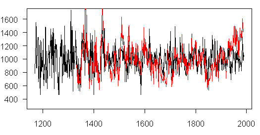
As I mentioned earlier today, Niwot Ridge is about 45 minutes drive from UCAR headquarters in Boulder (which hosts the IPCC WG1 TSU). I’ve identified 5 archived chronologies from Niwot Ridge, including two chronologies discussed in Kienast and Luxmoore 1988 as contradicting Graybill’s claims of enhanded post-1950 growth. Graumlich 1991 distinguished the two studies on the basis of altitude, but I pointed out that, at Niwot Ridge, the Graybill PIFL site was actually lower in altitude than the Kienast and Luxmoore sites (both PCEN). I also pointed out that Woodhouse did a PIFL study at the same altitude as Graybill, a few miles away. Anyway, here are the 5 tree ring width chronologies (there’s also an MXD chronology not shown so far.)


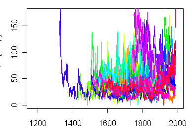
Niwot Ridge chronologies. Red- Graybill PIFL ‘ blue Woodhouse PIFL. 1) Hansen-Bristow PCEN; 2) Woodhouse PIFL; 3) Graybill PIFL; 4) Kienast PCEN; 5) Schweingruber PCEN (used in Kienast and Luxmoore).

The differences between the site chronologies are obviously quite remarkable. The Kienast and Schweingruber site chronologies do not appear to have been taken more than a few hundred yards from the Graybill chronology, although the species PCEN- Engelman spruce) differs from Graybill’s IFL (limber pine). However, Woodhouse is exactly the same species at the same altitude from a few miles away.

Here’s something amusing re MBH. The Woodhouse and Graybill site chronologies (both PIFL, both at the same altitude) are both used in MBH (for some reason, the Schweingruber and Kienast chronologies are not used, although many Schweingruber chronologies are). What are the weights of the two sites in the MBH98 PC1?

Site EOF1 Weight
Graybill co545 0.2299
Woodhouse co511 0.0025

So the HS-shaped series has a weight nearly 100 times larger than the non-HS shaped series, even though these are series of the same species within a couple of miles of one another. TCO has been grinding about why I regard this weighting as erroneous and what the correct weights should be? Or whether the "real " problem is the principal components methodology or the proxies?

I find it very difficult to be a judge at that particular beauty contest. How can one look at such disparate chronologies and come away with any view as to what the "correct" weighting is? How can both the Graybill chronology on the one hand and the Woodhouse/Kienast/Schweingruber chronologies on the other hand both be meaningful "proxies"? Yes, the HS shaped series is given 100 times the weight of the other series, but this is not just an error in geographical weighting. There’s something wrong with the method, as we’ve said from the beginning, with its biased picking; it’s not just that the geographic weights are wrong, but that it’s severely biased.

There’s also something fundamentally wrong with the confidence intervals claimed for tree ring chronologies. You see a statistic called the Subsample Signal Strength or Expressed Population Signal, where under the circumstances of any of these sites, the dendro people would claim that their signal is accurate to within very small percentages – but such claims are clearly unreconciliable with the big divergences between nearby series – a completely different Divergence Problem than the NAS Panel has in mind, but a big one nevertheless.

Another issue that I’m beginning to wonder about: how solid is the Graybill data anyway? The discrepancy between the HS-shaped Graybill series and the very different appearing Woodhouse, Kienast and Schweingruber series is worrying, although the Hansen-Bristow series has points in common with Graybill. There’s a lot of weight being placed on Graybill’s data – don’t you think that someone within the past 20 years should have replicated his results? (Oh, wait a minute, Hughes did resample Sheep Mountain in 2002 – it’s just that he hasn’t reported the results.) Tomorrow or the next day, I’m going to post up some worrying aspects to the Jacoby-D’Arrigo series at Churchill, Manitoba.

Update (Saturday):
Here is a figure showing the Graybill and Woodhouse PIFL chronologies on the same scale. Their correlation is 0.46. Graybill said that he was particularly looking for strip bark trees. Maybe that accounts for the difference. But the difference in 20th century HS-ness between samples taken by two different researchers on the same trees at the same elevation within a couple of miles of one another is pretty amazing and needs to be reconciled.

Rocky Mountain High #2

Pat Frank thought that I was being a little sarcastic of the rigors of updating tree ring collections at Niwot Ridge. However, I’d like now to give what is perhaps a better example of what Mann had in mind when he explained the inability of paleoclimatologists to update tree ring collections. Just to review, here’s Mann’s explanation of why they use proxies from the 1970s:

Most reconstructions only extend through about 1980 because the vast majority of tree-ring, coral, and ice core records currently available in the public domain do not extend into the most recent decades. While paleoclimatologists are attempting to update many important proxy records to the present, this is a costly, and labor-intensive activity, often requiring expensive field campaigns that involve traveling with heavy equipment to difficult-to-reach locations (such as high-elevation or remote polar sites). For historical reasons, many of the important records were obtained in the 1970s and 1980s and have yet to be updated.

Continue reading

Niwot Ridge, Colorado

Graumlich [1991] argued that it was “difficult” to compare the results of Lamarche et al [1984] and Graybill [1987] to Kienast and Luxmoore [1988] results, because 15 of 16 Lamarche-Graybill sites came from above 2800 m, while 30 of 34 Kienast and Luxmoore sites came from below 2000 m. While this is true, the two high-altitude Kienast and Luxmoore sites (Niwot Ridge and Arapahoe PCEN) come from a location that is very close to one of Graybill’s sites (Niwot Ridge PIFL). In fact, in this one overlapping case, the Kienast-Luxmoore sites actually come from slightly higher altitudes than the Graybill site and appear to be very close. Before doing the comprison, I thought that it would be interesting first to check out information on the site, check any other collections in the area.

In addition to these three collections, I was able to identify 2 other collections from the area, one a bristlecone sample taken in 1980 and one a PIFL site at a very similar altitude to the Graybill PIFL site taken a couple of years later up to 1989. No results have been archived from Niwot Ridge in the last 16 years. (For high-altitude sites i.e. above 3000 m in Colorado, no measurements have been archived for the last 12 years; 4 sites were archived in the early 1990s: two PCEN, one PIFL and one bristlecone – I’ll discuss these on another occasion).

Site/Species Lat (o ‘) Long Alt (m) End Author
Niwot Ridge PCEN co083 40 04 105 35 3700 1979 Hansen-Bristow
Niwot Ridge PCEN co574 40 03 105 34 3400 1983 Schweingruber
Arapahoe PCEN co517 40 03 105 35 3320 1983 Kienast
Niwot Ridge PIFL co545 40 03 105 33 3169 1987 Graybill
Island Lake PIFL co511 40 02 105 35 3200 1989 Woodhouse

One of the reasons for the lack of any updates since the 1980s is undoubtedly the rigors of getting to the site and bringing the samples back to civilization, in line with Mann’s comments at realclimate about the need to rely on samples taken from the 1970s and 1980s because of the expense and time needed to collect new samples.

Niwot Ridge is no less than 35 miles west of UCAR/NCAR headquarters in Boulder, Colorado and the drive is reported to take no less than 45 minutes. Intrepid explorers must plan an expedition for days in advance and are advised to pack a lunch. In this forbidding wilderness, explorers will be relieved by the vista of the Niwot Ridge Long-Term Ecological Research Station, established by NSF in 1980, continuing previous installations of the University of Colorado. Explorers unprepared for the rigors of this expedition can take a virtual field trip and even view live-cam images here and here . There are not one, but six meteorological stations, at varying altitudes up to 3743 m.

Here is a map of the Niwot Ridge area (from 40 00 45N to 40 04 15N; from 105 32 to 105 29W):

It looks to me like the Schweingruber, Kienast and Graybill samples are all taken just to the east of the “Subalpine Subniveau Lab”. Taking these samples might well have required a hike of 1-1.5 miles off the road to the laboratory. One can well understand why no explorer has re-sampled in such a dangerous location for nearly 20 years. Island Lake – the location of the Woodhouse samples – is the lake just to the west of Silver Lake, a couple of miles south of the lab. I can’t quite figure out where the Hansen-Bristow samples were taken from from the location map and the sketchy information on lat-long-altitude (which may not be consistent). I’ll post up the site chronologies tomorrow.

Other background information: it seems to me that many of the roads into the mountains were originally due to 19th century mining camps (which were typically very small vein mines that would be hard to locate today without a detailed location map) and I like to check out mining information related to these sites. There was a Niwot mine in the area mentioned here

The Ward district is 9-13 miles northwest of Boulder. It covered 12 square miles in headwaters of Lefthand and Fourmile Creeks. The old camps of Sunset and Copper Rock, more than 50 lode mines in area, had a total production of 172,000 ounces of lode gold. The Niwot and Columbia mines were the largest producers of lode gold. In east part of district, many mines produced gold in tellurides.

The Niwot Ridge meteorological station has operated since 1951. Here’s some information on this:

A continuous climate record since 1951 at Niwot Ridge in the Colorado Front Range shows a decline in mean annual temperature, an increase in annual precipitation amount, and a decrease in mean daily solar radiation for the summer months. The increase in precipitation amount explains about half of the 200% increase in annual wet deposition of NO3- to Niwot Ridge over the last decade. Differences in climate parameters between 1994 and 1995 (increased snow depth and decreased net energy flux to the snowpack) resulted in a 4 to 5-fold increase in the magnitude of solute release from the snowpack in the form of an ionic pulse. In turn, the high chemical loading of strong acid anions in the seasonal snowpack and release of these solutes from the seasonal snowpack in the form of an ionic pulse is causing episodic acidification (ANC < 0 meq/L) in headwater catchments at present deposition levels. Small changes in climate parameters may cause large changes in the hydrochemistry of alpine streams. The changes in climate at Niwot Ridge are not in synchrony with lowland warming in the Great Plains to the east of Niwot Ridge and serve as a reminder that climate in alpine areas is driven by local conditions and may be asynchronous with regional and global climate trends.

Nitrogen Saturation in the Rocky Mountains: Nitrogen (N) saturation is occurring throughout high-elevation catchments of the Colorado Front Range. Annual inorganic N loading in wet deposition to the Front Range of about 4 kg/ha/yr is about twice that of Pacific States and similar to many sites in the northeastern US. In the last ten years at Niwot Ridge/Green Lakes Valley and Glacier Lakes, annual minimum concentrations of NO3- in surface waters during the growing season have increased from below detection limits to about 10 meq/L, indicating that these two catchments are at the threshold of N saturation. The Loch Vale watershed is N saturated, with annual minimum concentrations of NO3- in surface waters generally above 10 meq/L; annual volume-weighted mean (VWM) concentrations of 16 meq/L NO3- in surface waters are greater than that of about 11 meq/L NO3- in wet deposition. At these high-elevation catchments there has been a shift in ecosystem dynamics from an N-limited system to an N-saturated system as a result of anthropogenically-fixed N in wetfall and dryfall. Results from the Western Lakes Survey component of the National Surface Water Survey show that N saturation is a regional problem in the Colorado Front Range, with many lakes having (NO3-) concentrations greater than 10 meq/L. Foliar N to P ratios in Bristlecone Pine increase with elevation in the Colorado Front Range, indicating that at higher elevations P is translocated from foliar tissue more efficiently than N and that increasing atmospheric deposition of N with elevation is causing a change from N limitation to P limitation in the highest-elevation Bristlecone Pines. Current concepts of critical loads need to be reconsidered since only modest atmospheric loadings of N are sufficient to induce N leaching to surface waters in high-elevation catchments of the western United States.

Ring Widths and Temperature #1

A common theme to recent questions has been the relationship of ring width chronologies to temperatures, and, in particular, the relationship of bristlecone chronologies to temperature. Rob Wilson has recently weighed in on this.

While it was nice of Rob to present some new material, people should not lose sight of the fact that the North American reconstruction presented by Rob is unpublished and it is based on unarchived material; his other comparandum, Salzer and Kipfmueller, is a very recent publication, again based on unarchived material.

So yes, the material is interesting and deserves consideration, but don’t you think that the matter should have been dealt with somewhere in the literature prior to the last few minutes? Continue reading

Server Problems

Apologies for the downtime. It was nothing to do with us; there were problems with the server. I probably should switch to another vendor.

Supplementary Comments to NAS Panel

We sent in the following two supplementary comments to the NAS Panel, one commenting on answers provided by Mann subsequent to our presentation and noting up points related to the revisions of Wahl and Ammann [2006] and rejection of the Ammann and Wahl submission to GRL here and the other responding to a question from one panellist on our suggestions on how to do a reconstruction better here.